 Mon GéoSource
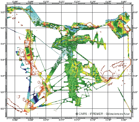
North Fiji Basin (Southwest Pacific) - 1000m
Bathymétrie du bassin Nord Fidjien produite à partir de plusieurs campagnes réalisées en 1985 et 1997
Simple
- Date ( Creation )
- 2001-03-20
- Identifier
- IFR_MBAN_DORSALES_PACIF_NORD_FIDJI_BATHY_1000_R
- Identifier
- DOI:10.12770/f651de98-9478-4d42-9dc9-c0ec7a43ae87
- Credit
- The project is part of the national program Dorsales and represents the French contribution to the InterRidge Data Banks project (see InterRidge News 1997, vol. 6/1 and 1999, vol. 8/1).
Publisher
Ifremer
+33 (0)2 98.22.46.44
http://www.ifremer.fr/sismer/
Centre IFREMER de Brest BP 70
,
PLOUZANE
,
29280
,
France
+33 (0)2 98.22.49.16
+33 (0)2 98.22.46.44
http://www.ifremer.fr/sismer/
- Thèmes Sextant Thèmes Sextant ( Theme )
-
- /Physical Environment/Bathymetry/Digital Terrain Model
- GEMET - INSPIRE themes, version 1.0 GEMET - INSPIRE themes, version 1.0 ( Theme )
-
- Elevation
- Type de jeux de donnée ODATIS Type de jeux de donnée ODATIS ( Theme )
-
- /Processed data/Model outputs
- Thématiques - SIMM Thématiques - SIMM ( Theme )
-
- /Etat du Milieu/Bathymétrie
- Use limitation
- CC-BY (Creative Commons - Attribution)
- Access constraints
- Other restrictions
- Use constraints
- License
- Other constraints
- Ruellan, E., Auzende, J.M. and Lagabrielle, Y., (in prep). Extension, sea-floor spreading and propagating rift in the North Fiji Basin (SW Pacific). G3
- Spatial representation type
- Grid
- Denominator
- 25000
- Metadata language
- fr
- Character set
- UTF8
- Topic category
-
- Elevation
N
S
E
W
))
- Begin date
- 1985-01-01T00:00:00
- End date
- 1997-12-31T00:00:00
- Reference system identifier
- EPSG / WGS 84 (EPSG:4326) / 8.6
- Number of dimensions
- 2
- Dimension name
- Column
- Resolution
- 1000 mètres
- Dimension name
- Row
- Resolution
- 1000 mètres
- Cell geometry
- Area
- Distribution format
-
-
(
)
-
(
)
- OnLine resource
-
MOHNS_BATHY
(
OGC:WMS
)
Bathymetry (WMS)
- Protocol
- FILE
- Name
- MOHNS_BATHY
- Description
- Bathymétrie - format .tif and .grd
- OnLine resource
-
DOI du jeu de données
(
WWW:LINK-1.0-http--metadata-URL
)
DOI du jeu de données
- Protocol
- COPYFILE
- Name
- IFR_MBAN_DORSALES_PACIF_NORD_FIDJI_BATHY_1000_R_GRD
- Description
- Bathymétrie 1000m - format .mnt
- OnLine resource
- DOI de la campagne - KAIYO ( WWW:LINK )
- OnLine resource
- DOI de la campagne - MULTIPSO ( WWW:LINK )
- OnLine resource
- DOI de la campagne - NOFI ( WWW:LINK )
- OnLine resource
- DOI de la campagne - SEAPSO 1 ( WWW:LINK )
- OnLine resource
- DOI de la campagne - SEAPSO 2 ( WWW:LINK )
- OnLine resource
- DOI de la campagne - SEAPSO 3 ( WWW:LINK )
- OnLine resource
- DOI de la campagne - SEAPSO 4 ( WWW:LINK )
- OnLine resource
- DOI de la campagne - SOPACMAPS ( WWW:LINK )
- Hierarchy level
- Dataset
- Statement
- Sources : Données de la campagne J. Charcot 1988, données Seabeam
- Description
- 0 spline en tension (surface)
- Rationale
- Interpolation
Content Information
No information provided.
- File identifier
- f651de98-9478-4d42-9dc9-c0ec7a43ae87 XML
- Metadata language
- fr
- Character set
- UTF8
- Hierarchy level
- Dataset
- Date stamp
- 2020-08-31T10:59:54
- Metadata standard name
- ISO 19115:2003/19139 - SEXTANT
- Metadata standard version
- 1.0
Overviews
Capture.PNG
Spatial extent
N
S
E
W
Provided by

Associated resources
Not available