 Mon GéoSource
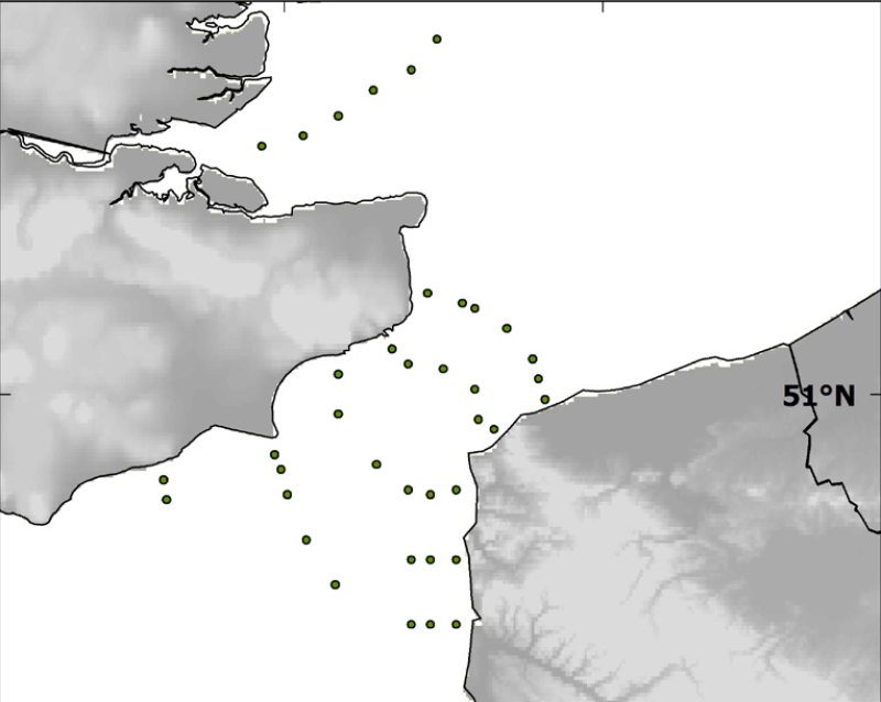
Species and habitats - Location of survey sampling stations of the BCD survey (april 1999)
Localisation of the 39 sampled sites done during the BCD survey in April 1999.
Simple
- Autres appellations ou acronymes
- BCD_general_ponctuel
- Autres appellations ou acronymes
- CHARM_STATION_BCD_PT
- Date ( Publication )
- 2009-12-31T00:00:00
- Identificateur
- CHARM_STATION_BCD_PT
- Forme de la présentation
- Carte numérique
- Autres informations de référence
- Source CHARM Consortium
- Reconnaissance
- Université du Littoral Côte d'Opale
- Reconnaissance
- CHARM Consortium
- Etat
- Finalisé
A l’origine de
Ifremer
-
Philippe Koubbi
UPMC Univ Paris 06, UMR 7093, Laboratoire d'Océanographie de Villefranche
,
Villefranche-sur-Mer
,
06230
,
France
- Fréquence de mise à jour
- Lorsque nécessaire
- Thèmes Sextant ( Thème )
-
- /Biological Environment/Species/Fish Species of Commercial Interest
- Mots clés ( Thème )
-
- Geographic localisation
- CHARM
- external.theme.gemet ( Thème )
-
- échantillonnage
- GEMET - INSPIRE themes, version 1.0 ( Thème )
-
- Habitats et biotopes
- Limitation d'utilisation
- research-only
- Contraintes d'accès
- Licence
- Autres contraintes
- Has to be cited this way in maps : "Source CHARM Consortium"
- Autres contraintes
- Has to be cited this way in bibliography : "Carpentier A, Martin CS, Vaz S (Eds.), 2009. Channel Habitat Atlas for marine Resource Management, final report / Atlas des habitats des ressources marines de la Manche orientale, rapport final (CHARM phase II). INTERREG 3a Programme, IFREMER, Boulogne-sur-mer, France. 626 pp. & CD-rom"
- Type de représentation spatiale
- Vecteur
- Dénominateur de l'échelle
- 10000
- Langue
- fr
- Langue
- en
- Jeu de caractères
- Utf8
- Catégorie ISO
-
- Imagerie/Cartes de base/Occupation des terres
- Limites
- Description de l'environnement de travail
- Microsoft Windows XP ; ESRI ArcGIS 9.x
- Identifiant géographique
- Dover Strait and river Thames mouth
N
S
E
W
))
- Date de début
- 1999-04-01
- Date de fin
- 1999-04-30
- Nom du système de référence
- 4326
- Niveau topologie
- Géométrie seulement
- Type de géométries des objets
- Point
- Nombre d'objets géométriques
- 39
Distributeur
- Ressource en ligne
- CHARM_STATION_BCD_PT ( OGC:WMS )
- Protocole
- FILE
- Nom
- CHARM_STATION_BCD_PT
- Ressource en ligne
-
CHARM web site
(
WWW:LINK
)
CHARM web site
- Niveau
- Jeu de données
- Généralités sur la provenance
- The BCD survey (¿Biodiversity and cartography throughout the Dover Straits¿) was held at the end of April 1999, with sampling from 39 stations. The BCD survey was financed by the European INTERREG II programme (1995-2001) and produced maps of larvae stages and plankton. The aims of the BCD survey was to compare planktonic assemblages on the French and English coasts. Ichthyoplankton was collected with a double-framed bongo net (plankton nets with 500 ¿m mesh). Oblique tows were carried out at 2 knots from the surface to the proximity of the seabed.
- Description
- BCD survey, scientific survey of ULCO
- Identifiant de la fiche
- 00319470-01e6-11e0-9e8f-005056987263 XML
- Langue
- en
- Jeu de caractères
- Utf8
- Type de ressource
- Jeu de données
- Date des métadonnées
- 2020-06-04T00:29:56
- Nom du standard de métadonnées
- ISO 19115:2003/19139 - SEXTANT
- Version du standard de métadonnées
- 1.0
Aperçus
Étendue spatiale
N
S
E
W
Fourni par

Ressources associées
Not available