 Mon GéoSource
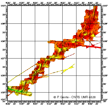
Dorsale médio-Atlantique entre 34 et 40°N - 500m
Identification d'une manière géophysique (magnétisme, gravimétrie et bathymétrie), les segments de la dorsale Atlantique entre 30 et 35N, actuels et passés (jusqu'à 10 millions d'années), en précisant leur géométrie et leurs frontières.
Simple
- Date ( Création )
- 1998-01-01
- Identificateur
- IFR_MBAN_DORSALES_ATLAN_34_40_BATHY_500_R
- Identificateur
- DOI:10.12770/707fcef3-7ad6-49a8-b615-6138b1904995
- Reconnaissance
- Le projet s'inscrit dans le cadre du programme national Dorsales et représente la contribution française au projet Banques de données du programme InterRidge (cf. InterRidge News 1997,vol. 6/1 et 1999, vol. 8/1).
Editeur (publication)
Ifremer
+33 (0)2 98.22.46.44
http://www.ifremer.fr/sismer/
Centre IFREMER de Brest BP 70
,
PLOUZANE
,
29280
,
France
+33 (0)2 98.22.49.16
+33 (0)2 98.22.46.44
http://www.ifremer.fr/sismer/
- Thèmes Sextant Thèmes Sextant ( Thème )
-
- /Milieu physique/Bathymétrie/MNT
- GEMET - INSPIRE themes, version 1.0 GEMET - INSPIRE themes, version 1.0 ( Thème )
-
- Altitude
- Type de jeux de donnée ODATIS Type de jeux de donnée ODATIS ( Thème )
-
- /Données dérivées/Données de type modèle
- Thématiques - SIMM Thématiques - SIMM ( Thème )
-
- /Etat du Milieu/Géologie
- /Etat du Milieu/Bathymétrie
- Thématiques - SIMM Thématiques - SIMM ( Thème )
-
- Recherche
- Limitation d'utilisation
- CC-BY (Creative Commons - Attribution)
- Contraintes d'accès
- Autres restrictions
- Contraintes d'utilisation
- Licence
- Autres contraintes
- THIBAUD R., GENTE P. and MAIA M., 1998. A systematic analysis of the Mid-Atlantic Ridge morphology and gravity between 15°N and 40°N : constraints of the thermal structure. J. Geophys. Res., 103, 24223-24243
- Type de représentation spatiale
- Raster
- Dénominateur de l'échelle
- 25000
- Langue
- fr
- Jeu de caractères
- Utf8
- Catégorie ISO
-
- Altitude
N
S
E
W
))
- Nom du système de référence
- EPSG / WGS 84 (EPSG:4326) / 8.6
- Dimensions
- 2
- Noms des axes
- Axe - X
- Résolution
- 0.00449113 degres
- Noms des axes
- Axe - Y
- Résolution
- 0.0045214 degres
- Type de raster
- Surface
- Format (encodage)
-
-
(
)
-
(
)
- Ressource en ligne
-
IFR_MBAN_DORSALES_ATLAN_34_40_BATHY_500_R
(
OGC:WMS
)
Bathymétrie à 500m de résolution
- Protocole
- FILE
- Nom
- IFR_MBAN_DORSALES_ATLAN_34_40_BATHY_500_R
- Description
- Bathymétrie 500m - format .tif
- Ressource en ligne
-
DOI du jeu de données
(
WWW:LINK-1.0-http--metadata-URL
)
DOI du jeu de données
- Protocole
- COPYFILE
- Nom
- IFR_MBAN_DORSALES_ATLAN_34_40_BATHY_500_R_GRD
- Description
- Bathymétrie 500m - format .grd
- Ressource en ligne
- DOI de la campagne - FARA - SEADMA I ( WWW:LINK )
- Niveau
- Jeu de données
- Généralités sur la provenance
- Non renseignée
Information sur le contenu
No information provided.
- Identifiant de la fiche
- 707fcef3-7ad6-49a8-b615-6138b1904995 XML
- Langue
- fr
- Jeu de caractères
- Utf8
- Type de ressource
- Jeu de données
- Date des métadonnées
- 2020-08-31T11:21:40
- Nom du standard de métadonnées
- ISO 19115:2003/19139 - SEXTANT
- Version du standard de métadonnées
- 1.0
Aperçus
Capture.PNG
Étendue spatiale
N
S
E
W
Fourni par

Ressources associées
Not available