 Mon GéoSource
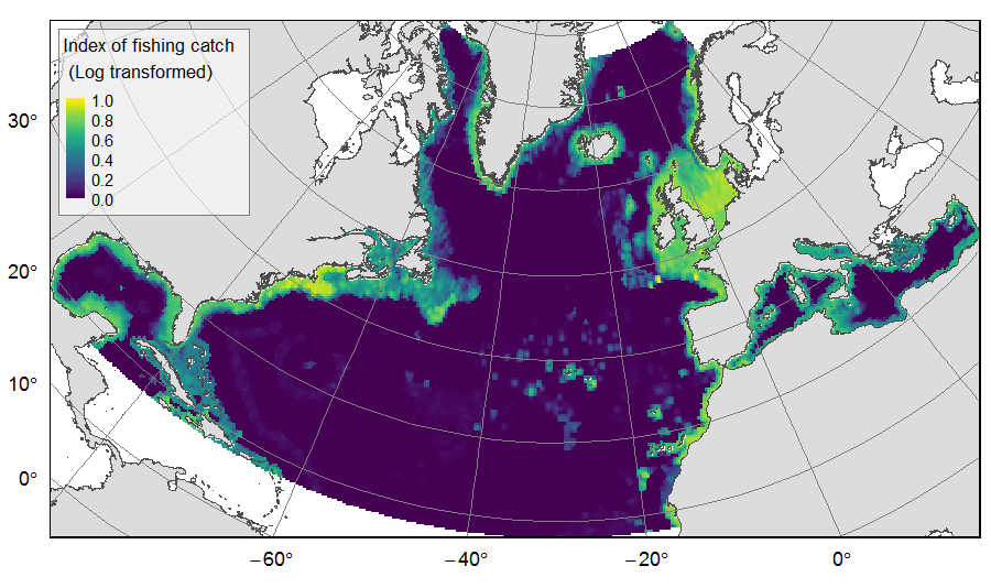
index of fishing catch from deep-sea impacting gears on the North Atlantic
Distribution of catch from deep-sea impacting fishing on the North Atlantic (18°N to 76°N and 36°E to 98°W), for the period 2010-2015. The average of yearly fishing catch for the period 2010-2015 is displayed as an index on the ATLAS grid of 25km * 25km resolution. Source data originated from the Global Fisheries Landings V4.0 database. The dataset was filtered to select only the fishing gears that have an impact on large areas of the seafloor (dredges, bottom trawls, and Danish seines). Within each cell, all remaining catch records were summed to get the total catch rate of the considered year.
This dataset was built to feed a basin-wide spatial conservation planning exercise, targeting the deep sea of the North Atlantic. The goal of this approach was to identify conservation priority areas for Vulnerable Marine Ecosystems (VMEs) and deep fish species, based on the distribution of species and habitats, human activities and current spatial management.
Simple
- Date ( Publication )
- 2019-08-14
- Identificateur
- FR-330-715-368-00032-IFR_MARBEC_ATLAS_Fishing_Catch
- Identificateur
- DOI:10.12770/79f078bf-7f80-4efc-a5b4-9e01609b6a51
- Reconnaissance
- Horizon 2020 ATLAS project (EU)
- Thèmes Sextant ( Thème )
-
- /Human Activities/Industrial Fishing
- GEMET - INSPIRE themes, version 1.0 ( Thème )
-
- Habitats and biotopes
- Limitation d'utilisation
- CC-BY-NC-SA (Creative Commons - Attribution, Pas d’utilisation commerciale, Partage dans les mêmes conditions)
- Contraintes d'accès
- Licence
- Contraintes d'utilisation
- Licence
- Type de représentation spatiale
- Raster
- Distance de résolution
- 25 km
- Langue
- en
- Jeu de caractères
- Utf8
- Catégorie ISO
-
- Océans
))
- Nom du système de référence
- +proj=aea +lat_1=43 +lat_2=62 +lat_0=30 +lon_0=-30 +x_0=0 +y_0=0 +datum=WGS84 +units=m +no_defs +ellps=WGS84 +towgs84=0,0,0
- Dimensions
- 2
- Noms des axes
- Axe - Y
- Nombre de pixel
- 273
- Résolution
- 25 km
- Noms des axes
- Axe - X
- Nombre de pixel
- 491
- Résolution
- 25 km
- Type de raster
- surface
- Disponibilité des paramètres de transformation
- Non
- Ressource en ligne
-
IFR_MARBEC_ATLAS_FISHING_LOG_INDEX
(
OGC:WMS
)
Fishing catch - log index 2010-2015 - North Atlantic
- Protocole
- COPYFILE
- Nom
- IFR_MARBEC_ATLAS_FISHING_LOG_INDEX
- Description
- Fishing catch - log index 2010-2015 - North Atlantic
- Ressource en ligne
- Watson, R. A., & Tidd, A. (2018). Mapping nearly a century and a half of global marine fishing: 1869–2015. Marine Policy, 93, 171–177. https://doi.org/10/gdsjxh ( WWW:LINK )
- Ressource en ligne
- Watson, R. A. (2017). A database of global marine commercial, small-scale, illegal and unreported fisheries catch 1950–2014. Nature Scientific Data, 4, 170039. https://doi.org/10/f92s7q ( WWW:LINK )
- Ressource en ligne
- Watson, R.A. (2019). Global Fisheries Landings V4.0. Institute for Marine and Antarctic Studies (IMAS), University of Tasmania (UTAS). doi:10.25959/5c522cadbea37 ( WWW:LINK )
- Ressource en ligne
-
DOI of the dataset
(
WWW:LINK-1.0-http--metadata-URL
)
DOI of the dataset
- Niveau
- Jeu de données
Résultat de conformité
- Date ( Publication )
- 2010-12-08
- Explication
- See the referenced specification
- Généralités sur la provenance
- The fishing catch for industrial and non-industrial fishing (Watson, 2019) on the 2010-2015 period was used. The yearly catch values were calculated in 25km * 25 km gridsquares of the raster grid used for the ATLAS spatial prioritization, and then averaged to get the mean yearly catch for the 6 years. This yearly catch was log transformed and expressed as an index varying from 0 to 1. Source data reference: Watson, R.A. (2019). Global Fisheries Landings V4.0. Institute for Marine and Antarctic Studies (IMAS), University of Tasmania (UTAS). doi:10.25959/5c522cadbea37
- Description
- The Global Fisheries Landings database displays annual catch rates (tonnes per square km of ocean) in each 30-min spatial cell of a global grid, for each fishing nation and fished taxa. Catch rate records are further disaggregated, assessing the contribution of the different fishing gears used, the different types of catch (illegal, unregulated and unreported, discards), and the scale of the fishing operations (industrial vs non-industrial) (Watson, 2017 ; Watson & Tidd, 2018).
- But du processus
- Global fishing catch
- Description
- Using the R environment, the fishing catch dataset for the 2010-2015 period was filtered to select only the fishing gears impacting the seafloor: dredges, bottom trawls, and Danish seines. For each record, the three catch values “Reported”, “IUU” and “Discards” were summed to get the total catch rate. All taxa and all nations total catch rates, for industrial and non-industrial fishing, were summed to get the yearly value of each spatial cell. The six yearly values by cell were then averaged to result in the final layer, on which one outlier point was deleted because of its high value compared to all others. The yearly average catch rate (annual tonnage per square km), displayed at a 30-min spatial resolution, was finally reprojected on the grid of 25km resolution using bilinear interpolation. Cells with NA values within the study area (no catch records attributed) were set to 0 while cells with values but out of the study zone were set to NA. For the purpose of spatial prioritization, the yearly catch was log transformed (log of catch value +1) and then rescaled in a continuous index from 0 to 1.
- But du processus
- filtering and extraction of catch on the ATLAS grid
- Identifiant de la fiche
- 79f078bf-7f80-4efc-a5b4-9e01609b6a51 XML
- Langue
- en
- Jeu de caractères
- Utf8
- Type de ressource
- Jeu de données
- Date des métadonnées
- 2019-11-04T21:13:19
- Nom du standard de métadonnées
- ISO 19115:2003/19139 - SEXTANT
- Version du standard de métadonnées
- 1.0
Aperçus
Étendue spatiale
Fourni par
