 Mon GéoSource
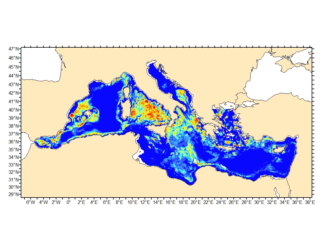
Mediterranean process-driven seafloor habitat sensitivity
Process-driven seafloor habitat sensitivity (PDS) has been defined from the method developed by Kostylev and Hannah (2007), which takes into account physical disturbances and food availability as structuring factors for benthic communities. It is a conceptual model, relating species’ life history traits to environmental properties. Physical environment maps have been converted into a map of benthic habitat types, each supporting species communities with specific sensitivity to human pressures. It is based on two axes of selected environmental forces.
The "Disturbance" (Dist) axis reflects the magnitude of change (destruction) of habitats (i.e. the stability through time of habitats), only due to natural processes influencing the seabed and which are responsible for the selection of life history traits. The "Scope for Growth" (SfG) axis takes into account environmental stresses inducing a physiological cost to organisms and limiting their growth and reproduction potential. This axis estimates the remaining energy available for growth and reproduction of a species (the energy spent on adapting itself to the environment being already taken into account). It can be related to the metabolic theory of the ecology.
The process-driven sensitivity (PDS) can be seen as a risk map that combines the two previous axes and reflects the main ecological characteristics of the benthic habitats regarding natural processes. Areas with low disturbance are areas with a naturally low reworking of the sediment, allowing the establishment of a rich sessile epifauna community, with K-strategy species. Areas with low SfG means that the environmental factors, even though there are not limiting, are in lower values, i.e. that it imposes a cost for species to live. In areas combining low disturbance and low SfG, big suspension-feeder species with long life and slow growth can often be found: these species are more vulnerable in case of added disturbance.
Simple
- Date ( Publication )
- 2016-09-20T00:00:00
- Identificateur
- DOI:10.12770/9228291d-fd7b-4a16-a7c3-b6b80d341257
- Reconnaissance
- IFREMER
- Thèmes Sextant Thèmes Sextant ( Thème )
-
- /Milieu biologique/Habitats
- GEMET - INSPIRE themes, version 1.0 GEMET - INSPIRE themes, version 1.0 ( Thème )
-
- Habitats et biotopes
- Sous-regions marines Sous-regions marines ( Localisation )
-
- /Métropole/Méditerranée occidentale
- Thématiques - SIMM Thématiques - SIMM ( Thème )
-
- /Etat du Milieu/Géologie
- /Etat du Milieu/Hydrodynamique
- Recherche
- /Etat du Milieu/Habitats
- Type de jeux de donnée ODATIS Type de jeux de donnée ODATIS ( Thème )
-
- /Données dérivées/Produits composites
- Limitation d'utilisation
- CC-BY-NC-SA (Creative Commons - Attribution, Pas d’utilisation commerciale, Partage dans les mêmes conditions)
- Contraintes d'accès
- Autres restrictions
- Contraintes d'utilisation
- Autres restrictions
- Type de représentation spatiale
- Raster
- Langue
- en
- Jeu de caractères
- Utf8
- Catégorie ISO
-
- Environnement
))
- Date de début
- 1998-01-01T00:00:00
- Date de fin
- 2014-12-31T00:00:00
- Nom du système de référence
- EPSG / WGS 84 (EPSG:4326) / 8.6
- Type de géométries des objets
- Composite
- Format (encodage)
-
-
(
)
-
(
)
- Ressource en ligne
- MyOcean ( WWW:LINK )
- Ressource en ligne
- EMODnet Bathymetry Consortium (2018): EMODnet Digital Bathymetry (DTM). ( WWW:LINK )
- Ressource en ligne
- Density of sea water at high pressure from temperature and salinity ( WWW:LINK )
- Ressource en ligne
- The equation of dissolved oxygen concentration in the water ( WWW:LINK )
- Ressource en ligne
- R.F. Weiss, 1970. The solubility of nitrogen, oxygen and argon in water and seawater, Deep Sea Research and Oceanographic Abstracts, Volume 17, Issue 4, 1970, Pages 721-735, ISSN 0011-7471, ( WWW:LINK )
- Ressource en ligne
-
Habitat_sensitivity_sfg
(
OGC:WMS
)
Scope for Growth
- Ressource en ligne
-
Habitat_sensitivity_risk
(
OGC:WMS
)
Risk
- Ressource en ligne
-
Habitat_sensitivity_dist
(
OGC:WMS
)
Disturbance
- Protocole
- COPYFILE
- Nom
- Scope for Growth
- Protocole
- COPYFILE
- Nom
- Risk
- Protocole
- COPYFILE
- Nom
- Disturbance
- Ressource en ligne
- DOI of the dataset ( WWW:LINK )
- Niveau
- Jeu de données
- Généralités sur la provenance
-
Disturbance was computed by combining:
- Seabed shear stress (in N.m-2) based on Mediterranean modelled seabed shear stress (90th percentile)
- Sediment average grain size based on Modelled seabed sediment average grain size in the Mediterranean
Scope for Growth factors involved are:
- Surface Chlorophyll a (Chl.a ; mg.m-3)
Computed as maximum concentration of surface chlorophyll obtained from monthly satellite observations from 1998 to 2014 (MyOcean (http://marine.copernicus.eu/): "OCEANCOLOUR_MED_CHL_L4_REP_OBSERVATIONS_009_078").
- Bathymetry
EMODnet Bathymetry Consortium (2018): EMODnet Digital Bathymetry (DTM). http://doi.org/10.12770/18ff0d48-b203-4a65-94a9-5fd8b0ec35f6
- Stratification
Here, stratification was considered as the average absolute difference between surface and 30 (± 5) m depth density over 20 years. Salinity and temperature data used to compute density cover the 1994-2014 period and were from monthly model predictions (MyOcean (http://marine.copernicus.eu/): "MEDSEA_REANA-LYSIS_PHYS_006_004"). High Pressure International Equation of State of Seawater (1980) was used to compute Sea water Density. The description of the computation of density of sea water at high pressure from temperature and salinity is available at https://www.niot.res.in/COAT/coat_pdf/CHAP%20III%20-%20Equation%20of%20State.pdf.
- Bottom temperatures from 1994 à 2014 from monthly model predictions (MyOcean (http://marine.copernicus.eu/): "MEDSEA_REANA-LYSIS_PHYS_006_004") were used to compute average bottom temperature (BT), inter- and intra-annual bottom temperature standard deviations (Ti and Ta respectively). Ti, is the standard deviation between yearly averages and Ta, is the standard deviation between months averages.
- Average bottom disolved oxygen concentration (O ; mmol.m-3) from1999 to 2014, from monthly model predictions (MyOcean (http://marine.copernicus.eu/): "MEDSEA_REANALYSIS_BIO_006_008"). This was further transformed in % disolved oxygen using the equation of dissolved oxygen concentration in the water (after Weiss, 1970) found in JFE Advantech Co.,Ltd., Ocean and River Instruments Division, 2015 (http://ocean.jfe-advantech.co.jp/english/sensor/img/do.pdf)
R.F. Weiss, 1970. The solubility of nitrogen, oxygen and argon in water and seawater, Deep Sea Research and Oceanographic Abstracts, Volume 17, Issue 4, 1970, Pages 721-735, ISSN 0011-7471, https://doi.org/10.1016/0011-7471(70)90037-9.
- Description
-
The critical shear stress is the the minimal critical current needed to initiate sedimentary movement and was computed as a function of the log grain size (X, gain size in mm) and derived from the Hjulström diagram empirically approximated by the equation: Y= -0.0272 × X^4- 0.0905 ×X^3+ 0.2411 × X^2+ 0.4691×X+1.8761 and critical shear stress = (10^y)/100
Seabed shear stress (in N.m-2) was used to describe friction intensity.
All layers were limited to the same extent and rasterised at the same resolution (by bilinear interpolation).
The disturbance was then defined as
Dist = log(friction intensity/ critical shear stress)
followed by centering, standardisation and rescaling between 0-1.
- But du processus
- Disturbance (Dist) computation
- Description
-
Before compiling the different environmental layers to define the scope for growth, data were recoded between 0 and 1. Since this reclassification is sensible to the geographical extent of the studied area, all layers were limited to the same extent and rasterised at the same resolution (by bilinear interpolation).
The equation to calculate scope for growth is defined as:
SfG= (Fa+Temp+O)/3
with Fa, food availability, Temp, temperature impact, O, %dissolved oxygen. SfG was then centered, standardised and rescaled between 0-1
Food availability was computed as:
Fa = F - stratification
F=log(Chl.a/bathymetry), followed by centering, standardisation and rescaling between 0-1 and stratification was also centered, standardised and rescaled between 0-1 before computing Fa. Once computed Fa was also centered, standardised and rescaled between 0-1.
Temperature impact was computed as
Temp= BT-Ta-Ti, followed by centering, standardisation and rescaling between 0-1
%dissolved oxygen was expressed as ratio instead of %.
- But du processus
- Scope for Growth (SfG) computation
- Description
-
The process-driven sensitivity (PDS) can be seen as a risk map that combines the two previous axes, according the formula :
risk =sqrt[(1-SfG)²+(1-Dist)²]
followed by centering, standardisation and rescaling between 0-1
- But du processus
- Process-driven sensitivity (PDS) computation
- Identifiant de la fiche
- 9228291d-fd7b-4a16-a7c3-b6b80d341257 XML
- Langue
- en
- Jeu de caractères
- Utf8
- Type de ressource
- Jeu de données
- Date des métadonnées
- 2021-02-05T09:56:00
- Nom du standard de métadonnées
- ISO 19115:2003/19139 - SEXTANT
- Version du standard de métadonnées
- 1.0
Aperçus
Étendue spatiale
Fourni par
