 Mon GéoSource
ARCWIND - Satellite Ocean Data - 0.125deg
Simple
- Date ( Création )
- 2018-10-11
- Identificateur
- FR-330-715-368-00032-DATARMOR_ARCWIND_0125
- Identificateur
- DOI:10.12770/9d716911-0886-486e-9da5-976c31038609
- Reconnaissance
- Ifremer - Laboratoire d'Océanographie Physique et Spatiale
02 98 22 45 33
02 98 22 45 33
02 98 22 45 33
02 98 22 45 33
- GEMET - INSPIRE themes, version 1.0 ( Thème )
-
- Meteorological geographical features
- Thèmes Sextant ( Thème )
-
- /Physical Environment/Climatology
- Sous-regions marines ( Localisation )
-
- /France
- Thématiques - SIMM ( Thème )
-
- /Environmental Status/Hydrodynamics
- Research
- Type de jeux de donnée ODATIS ( Thème )
-
- /Processed data/Model outputs
- Limitation d'utilisation
- CC-BY (Creative Commons - Attribution)
- Contraintes d'accès
- Licence
- Contraintes d'utilisation
- Licence
- Type de représentation spatiale
- Raster
- Langue
- en
- Jeu de caractères
- Utf8
- Catégorie ISO
-
- Océans
))
- Date de début
- 2004-01-01
- Date de fin
- 2013-12-31
- Nom du système de référence
- EPSG / WGS 84 (EPSG:4326) / 8.6
- Niveau topologie
- Géométrie seulement
- Dimensions
- 2
- Noms des axes
- Axe - X
- Nombre de pixel
- 88
- Résolution
- 0.125 degres
- Noms des axes
- Axe - Y
- Nombre de pixel
- 97
- Résolution
- 0.125 degres
- Type de raster
- Surface
- Format (encodage)
-
-
(
)
-
(
)
- Ressource en ligne
-
DOI of the dataset
(
WWW:LINK-1.0-http--metadata-URL
)
DOI of the dataset
- Ressource en ligne
-
Publication
(
WWW:LINK-1.0-http--publication-URL
)
Abderrahim Bentamy, Alexis Mouche, Antoine Grouazel, Abderrahim Moujane & Aït Ahmed Mohamed (2019) Using sentinel-1A SAR wind retrievals for enhancing scatterometer and radiometer regional wind analyses, International Journal of Remote Sensing, 40:3, 1120-1147, DOI: 10.1080/01431161.2018.1524174
- Ressource en ligne
- /home/ref-sat-arcwind/12km6h ( NETWORK:LINK )
- Ressource en ligne
- wind_speed ( OGC:WMS )
- Ressource en ligne
- Download link ( WWW:DOWNLOAD-1.0-link--download )
- Ressource en ligne
-
script:arcwind_12km_maps
(
OGC:WPS
)
Arcwind 12km Maps
- Ressource en ligne
-
script:arcwind_12km_ts
(
OGC:WPS
)
Arcwind 12km Timeseries
- Ressource en ligne
-
script:arcwind_12km_wind_stats
(
OGC:WPS
)
Arcwind 12km Stats
- Ressource en ligne
- Opendap ( WWW:DOWNLOAD-1.0-link--download )
- Niveau
- Jeu de données
- Généralités sur la provenance
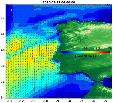
- One the main of objective of ARCWIND project is to better improve the surface wind space and time characteristics relied on the main weather conditions occurring over the ARCWIND oceanic zones (North Atlantic ocean basins). They are required for the characterization the wind energy simulation and production, site selection, and machine maintenance. Radars and radiometers onboard polar satellites provide valuable information on surface winds, with high spatial resolution, and global coverage. The satellite observation allow access to synoptic and global estimates of geophysical parameters with high spatial resolution ranging between 1km and 50km with an accuracy equivalent to that estimated from the buoy measurements. The characteristics of the satellite surface wind speeds and directions useful for ARCWIND achievements are summarized in Table 1. It provides satellite mission, onboard instrument of interest for the project, period of data availability at IFREMER archiving center, repeat orbit (i.e. requiring time between two successive observations at same location) for polar sun-synchronous satellites, space grid resolution (i.e. also called Wind Vector Cell (WVC)), centers producing and distributing data, and center where data are available for the project. For ARCWIND project purposes more than 25 independent wind sources will be used including 10 scatterometers, 2 SAR, 9 radiometers, and 6 altimeters. More specifically, the European Space Agency (ESA) operated two scatterometers onboard the European Remote Sensing Satellites ERS-1 (1991 – 1996) and ERS-2 (1995 – 2011). Three scatterometers have been operated by the National Aeronautic Space Administration (NASA): NASA scatterometer (NSCAT) (1996 – 1997) onboard the Japanese Advanced Earth Observing Satellite (ADEOS-1), SeaWinds onboard QuikSCAT satellite (1999 - 2009), and SeaWinds onboard (ADEOS-2/Midori) (2002 – 2003). The latest European scatterometers are the Advanced SCATterometer ASCAT-A (2006 – present) and ASCAT-B (2013 – present) onboard METOP-A and –B satellites, Ocean SCATterometer (OSCAT) onboard OCEANSAT2 satellite (2009 – present), and HY-2A scatterometer (2011 – present). ASCAT-A/B, OSCAT, and HY-2A are operated by European Meteorological Satellite organization (EUMETSAT), and the Indian Space Research Organization (ISRO), respectively. Higher wind speed and direction retrievals would be derived from two SAR onboard ENVISAT and SENTINEL 1A ESA satellites, respectively. To enhance surface wind sampling in space and time over ARCWIND oceanic areas, winds from radiometers such as the Special Sensor Microwave Imager (SSM/I) on board Defense Meteorological Satellite Program (DMSP) F10, F11, F13, F14, and F15, F16, F17, and F18 satellites, the polarimetric radiometer WindSat onboard CORIOLIS satellites, are also used. All wind speeds and directions available for the project are related to level 2 product (data over instrument swath or along tracks) associated with each satellite mission and provided by the producer agencies (CNES, ESA,EUMETSAT OSI SAF, IFREMER, KNMI, NASA, RSS). Scatterometers, SAR, and WindSat provide valuable information on both wind speed and direction, whereas passive microwave imagers (e.g. SSM/I) and altimeters provide information on wind speed (only). Radars and radiometers provide accurate retrievals in almost all atmospheric and oceanic conditions. In general, they are available with a spatial resolution lower than 1km for SAR, 7km along altimeter tracks, and varying between 25 and 12.5 km² for scatterometers and radiometers. . To overcome near coast winds, not available from scatterometers and radiometers, the project uses use SAR data.
- Identifiant de la fiche
- 9d716911-0886-486e-9da5-976c31038609 XML
- Langue
- en
- Jeu de caractères
- Utf8
- Type de ressource
- Jeu de données
- Date des métadonnées
- 2021-08-11T16:59:12
- Nom du standard de métadonnées
- ISO 19115:2003/19139 - SEXTANT
- Version du standard de métadonnées
- 1.0
02 98 22 45 33
Aperçus
Étendue spatiale
Fourni par
