 Mon GéoSource
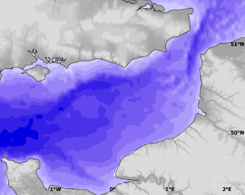
Physical environment - Modelled depth data (bathymetry plus sea level)
Depth is here bathymetry plus mean sea level. It adds the bathymetry raster to that of mean sea level. Depth is more relevant than bathymetry alone for ecological point of view. Used as layer for habitat
Simple
- Autres appellations ou acronymes
- SHOM-IFR_environment_model
- Date ( Publication )
- 2009-12-31T00:00:00
- Identificateur
- CHARM_SHOMIFR_BATHY_R
- Forme de la présentation
- Carte numérique
- Autres informations de référence
- Source CHARM Consortium
- Reconnaissance
- SHOM / IFREMER
- Reconnaissance
- CHARM consortium
- Etat
- Finalisé
- Fréquence de mise à jour
- Lorsque nécessaire
- Thèmes Sextant ( Thème )
-
- /Physical Environment/Physical Habitats
- Mots clés ( Discipline )
-
- Oceanography
- CHARM
- GEMET - INSPIRE themes, version 1.0 ( Thème )
-
- Altitude
- external.theme.gemet ( Thème )
-
- modèle terrestre numérique
- océanographie
- Limitation d'utilisation
- research-only
- Contraintes d'accès
- Licence
- Autres contraintes
- Has to be cited this way in maps : "Source CHARM Consortium"
- Autres contraintes
- Has to be cited this way in bibliography : "Carpentier A, Martin CS, Vaz S (Eds.), 2009. Channel Habitat Atlas for marine Resource Management, final report / Atlas des habitats des ressources marines de la Manche orientale, rapport final (CHARM phase II). INTERREG 3a Programme, IFREMER, Boulogne-sur-mer, France. 626 pp. & CD-rom"
- Type de représentation spatiale
- Raster
- Dénominateur de l'échelle
- 1000
- Langue
- fr
- Langue
- en
- Jeu de caractères
- Utf8
- Catégorie ISO
-
- Océans
- Description de l'environnement de travail
- Microsoft Windows XP ; ESRI ArcGIS 9.x
- Identifiant géographique
- Eastern English Channel
N
S
E
W
))
- Nom du système de référence
- 4326
Distributeur
- Ressource en ligne
-
CHARM web site
(
WWW:LINK
)
CHARM web site
- Protocole
- COPYFILE
- Nom
- Depth
- Description
- Depth
- Ressource en ligne
- CHARM_SHOMIFR_BATHY_R ( OGC:WMS )
- Niveau
- Jeu de données
- Généralités sur la provenance
- Bathymetric data (or zero level, or low tide, corresponding to a tidal coefficient of 120) were derived from SHOM navigation charts. A regular square grid of 1.8 km² resolution, approximately corresponding to the English Channel, was obtained. Mean sea level (or mid-tide, corresponding to a tidal coefficient of 70) was estimated with the MARS 3D hydrodynamic model (Le Roy & Simon, 2003). This model solves equations of Saint-Venant type, to estimate mean current and the position of the free surface of the sea. This model is built on the basis of a regular square grid using sigma coordinates (with the same number of layers across the study area) and is applicable to an area extending from the Lizard Point to the north of the Rhine river on the continent.
- Description
- The regular grids obtained for bathymetric data and mean sea level were interpolated using ArcMap to create continuous raster layers of 1 km² resolution. The bathymetric and mean sea level raster layers were then summed by using ArcMap's Raster Calculator extension to create the depth layer, that is to say the layer of bathymetry plus mean sea level. Finally, the resulting layer was cut to the size of CHARM's study area using ArcMap's Raster Calculator extension.
- Description
- SHOM (Service Hydrographique et Océanographique de la Marine) and IFREMER (Institut Français de Recherche pour l'Exploitation de la MER).
- Identifiant de la fiche
- b8863996-5b80-4357-97e2-5638364d2a23 XML
- Langue
- en
- Jeu de caractères
- Utf8
- Type de ressource
- Jeu de données
- Date des métadonnées
- 2020-06-04T00:43:35
- Nom du standard de métadonnées
- ISO 19115:2003/19139 - SEXTANT
- Version du standard de métadonnées
- 1.0
Aperçus
Étendue spatiale
N
S
E
W
Fourni par

Ressources associées
Not available