 Mon GéoSource
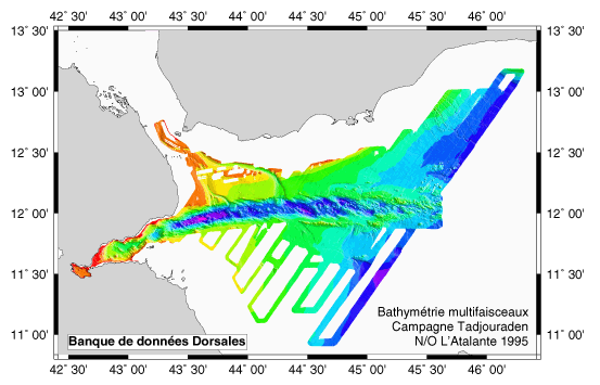
Bathymétrie multifaisceaux – Campagne Tadjouraden – N/O L’Atalante 1995 - 250m
Levés EM12 et EM 950 + gravimétrie, magnétisme et sismique rapide pour étude du mécanisme de propagation de la dorsale océanique du golfe d'Aden vers l'ouest (golfe de Tadjoura et Ghoubbet).
Simple
- Date ( Création )
- 2002-01-31
- Identificateur
- IFR_MBAN_DORSALES_INDIEN_TADJOURADEN_BATHY_250_R
- Identificateur
- DOI:10.12770/c23d1636-a3cd-4cc9-b141-360277ec0e01
- Reconnaissance
- Le projet s'inscrit dans le cadre du programme national Dorsales et représente la contribution française au projet Banques de données du programme InterRidge (cf. InterRidge News 1997,vol. 6/1 et 1999, vol. 8/1).
Editeur (publication)
Ifremer
+33 (0)2 98.22.46.44
http://www.ifremer.fr/sismer/
Centre IFREMER de Brest BP 70
,
PLOUZANE
,
29280
,
France
+33 (0)2 98.22.49.16
+33 (0)2 98.22.46.44
http://www.ifremer.fr/sismer/
- Thèmes Sextant Thèmes Sextant ( Thème )
-
- /Milieu physique/Bathymétrie/MNT
- GEMET - INSPIRE themes, version 1.0 GEMET - INSPIRE themes, version 1.0 ( Thème )
-
- Altitude
- Type de jeux de donnée ODATIS Type de jeux de donnée ODATIS ( Thème )
-
- /Données dérivées/Produits composites
- Thématiques - SIMM Thématiques - SIMM ( Thème )
-
- Recherche
- Thématiques - SIMM Thématiques - SIMM ( Thème )
-
- /Etat du Milieu/Bathymétrie
- Sous-regions marines Sous-regions marines ( Localisation )
-
- /Outre-mer/Océan Indien
- Limitation d'utilisation
- CC-BY (Creative Commons - Attribution)
- Contraintes d'accès
- Autres restrictions
- Contraintes d'utilisation
- Licence
- Autres contraintes
- Hébert H., Deplus C., Huchon P., Khanbari K. et Audin L., 2001 - Lithospheric structure of a nascent spreading ridge inferred from gravity data: the western Gulf of Aden - J. Geophys. Res., 106 (B11), 26,345-26,363.
- Type de représentation spatiale
- Raster
- Dénominateur de l'échelle
- 25000
- Langue
- fr
- Jeu de caractères
- Utf8
- Catégorie ISO
-
- Altitude
N
S
E
W
))
- Date de début
- 1995-08-21
- Date de fin
- 1995-09-08
- Nom du système de référence
- EPSG / WGS 84 (EPSG:4326) / 8.6
- Dimensions
- 2
- Noms des axes
- Axe - X
- Résolution
- 0.25 kilomètres
- Noms des axes
- Axe - Y
- Résolution
- 0.25 kilomètres
- Type de raster
- Surface
- Format (encodage)
-
-
(
)
-
(
)
- Ressource en ligne
-
IFR_MBAN_DORSALES_INDIEN_TADJOURADEN_BATHY_250_R
(
OGC:WMS
)
Bathymétrie à 250m de résolution
- Protocole
- COPYFILE
- Nom
- IFR_MBAN_DORSALES_INDIEN_TADJOURADEN_BATHY_250_R
- Description
- Bathymétrie 250m - format .tif
- Ressource en ligne
-
DOI du jeu de données
(
WWW:LINK-1.0-http--metadata-URL
)
DOI du jeu de données
- Protocole
- COPYFILE
- Nom
- IFR_MBAN_DORSALES_INDIEN_TADJOURADEN_BATHY_250_R_GRD
- Description
- Bathymétrie 250m - format .grd
- Ressource en ligne
- DOI de la campagne - TADJOURADEN ( WWW:LINK )
- Niveau
- Jeu de données
- Généralités sur la provenance
- Sources : Données de la campagne Tadjouraden du N/O L’Atalante en 1995 - SIMRAD EM12 Dual + EM 950
- Description
- Maillage réalisé à bord par l’opérateur rejeu à l’ai de du logiciel Trismus
- But du processus
- Interpolation
- Description
- Passage du format Trismus au format binaire GMT sans remaillage
- But du processus
- Masquage
Information sur le contenu
No information provided.
- Identifiant de la fiche
- c23d1636-a3cd-4cc9-b141-360277ec0e01 XML
- Langue
- fr
- Jeu de caractères
- Utf8
- Type de ressource
- Jeu de données
- Date des métadonnées
- 2021-09-09T15:33:21
- Nom du standard de métadonnées
- ISO 19115:2003/19139 - SEXTANT
- Version du standard de métadonnées
- 1.0
Aperçus
tadji.png
Étendue spatiale
N
S
E
W
Fourni par

Ressources associées
Not available