 Mon GéoSource
Mer d'Iroise
Type of resources
Available actions
INSPIRE themes
Provided by
Years
Formats
Representation types
Update frequencies
status
Scale
-
The term "boulder fields" covers areas of boulders of the lowest levels of the foreshore which are uncovered during low tides. They are not really part of the mediolittoral (intertidal zone) but what is now defined as the fringe tip (or emerging or upper part) of the infralittoral. More generally, boulder fields, formed by the fragmentation of the rocks in place, are located at the foot of rocky cliffs or between rocky headlands and flats. They are only accessible on foot during tidal coefficients greater than or equal to 95. Boulder fields naturally harbor a high biodiversity due to their position at the bottom of the foreshore, but the wealth of fauna and flora also depends greatly on the type of architectural habitat. Three broad categories of boulder fields are distinguished: Sediment blocks, blocks of bedrock and blocks on blocks.
-
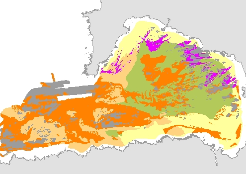
La carte numérique des peuplements benthiques de la zone subtidale du secteur Douarnenez a été publiée en 2005 dans l'Atlas thématique de l'environnement marin de la baie de Douarnenez (Partenariat Ifremer et ville de Douarnenez, Ed. Ifremer, Coordination Augris C.). Différentes méthodes ont été employées : méthodes acoustiques (sonar à balayage latéral, sondeur multifaisceaux), prélèvements d'échantillons (benne Hamon), observations sous-marines (vidéo). La typologie des habitats a été élaborée par les auteurs suivants : D. Hamon, A. Blanchet, C. Chevalier (Ifremer/Dyneco/Benthos).