 Mon GéoSource
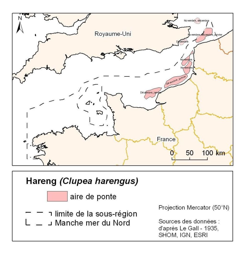
Downs herring spawning grounds
Distribution of spawning herring in the North Atlantic (Clupea harengus) in the Eastern Channel (Downs herring) between November and January. Eggs are laid on the gravel bottom between 20 and 40 m deep.
Simple
- Date ( Creation )
- 2011-05-01
- Identifier
- FR-330-715-368-00024_ifr_frayeresHareng_wgs84_P
- Credit
- Ifremer - Laboratoire Ressources Halieutiques de Boulogne-sur-Mer
Point of contact
IFREMER
-
Verin Yves
03 21 99 56 01
Centre Manche Mer du Nord - 150, Quai Gambetta - 62200 Boulogne-sur-Mer
,
Boulogne
,
France
03 21 99 56 08
03 21 99 56 01
- Thèmes Sextant Thèmes Sextant ( Theme )
-
- /Biological Environment/Species/Fish Species of Commercial Interest
- GEMET - INSPIRE themes, version 1.0 GEMET - INSPIRE themes, version 1.0 ( Theme )
-
- Species distribution
- external.theme.gemet external.theme.gemet ( Theme )
-
- Spawn
- Keywords ( Theme )
-
- Herring
- Keywords ( Place )
-
- Eastern Channel
- Sous-regions marines Sous-regions marines ( Place )
-
- Channel-North Sea
- Access constraints
- Copyright
- Use constraints
- Copyright
- Classification
- Unclassified
- Spatial representation type
- Vector
- Metadata language
- fr
- Character set
- UTF8
- Topic category
-
- Biota
- Oceans
N
S
E
W
))
- Reference system identifier
- EPSG / WGS 84 (EPSG:4326) / 7.4
- Distribution format
-
-
Shape ESRI
(
ArcGIS 9.3.1
)
-
Shape ESRI
(
ArcGIS 9.3.1
)
- OnLine resource
- site internet Ifremer dédié à la Directive Cadre Stratégie pour le Milieu Marin ( WWW:LINK )
- OnLine resource
-
carthothèque DCSMM
(
WWW:LINK
)
Pelagic fish populations (small pelagics)
- OnLine resource
-
ifr_frayeresHareng_wgs84_p
(
OGC:WMS
)
Spawn
- Hierarchy level
- Dataset
- Statement
- This map is a modified digital version of Le Gall J., Herring, Clupea harengus, 1935. Annales de l’institut océanographique. Tome XV – Fac. 1. Spawning grounds were transcribed by hand on GIS maps from this book.
- File identifier
- 7e11d141-7763-4567-ac66-d86909bdae2c XML
- Metadata language
- fr
- Character set
- UTF8
- Hierarchy level
- Dataset
- Hierarchy level name
- Jeu de données
- Date stamp
- 2020-06-04T01:01:06
- Metadata standard name
- ISO 19115:2003/19139 - SEXTANT
- Metadata standard version
- 1.0
Point of contact
IFREMER
-
Vaz Sandrine
Station de Sète - Avenue Jean Monnet - CS 30171 - 34203 Sète Cedex
,
Sete
,
France
Overviews
Spatial extent
N
S
E
W
Provided by

Associated resources
Not available