 Mon GéoSource
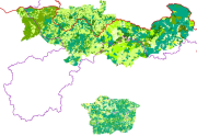
Carte vectorielle de la végétation du Projet AGIR, 2002-2005
Carte vectorielle de la végétation et des zonages administratifs, projet AGIR (Guinée, Mali, Sénégal). La végétation comporte 20 classes, essentiellement forestières
Simple
- Date ( Creation )
- 2003-03-06
- GEMET - INSPIRE themes, version 1.0 ( Theme )
-
- Occupation des terres
- Keywords ( Theme )
-
- Végétation
- Projet AGIR
- Sénégal
- Guinée
- Mali
- Access constraints
- Other restrictions
- Other constraints
- Pas de restriction d’accès public selon INSPIRE
- Use limitation
- Utilisation libre sous réserve de mentionner la source (a minima le nom du producteur) et la date de sa dernière mise à jour
- Metadata language
- fre
- Character set
- UTF8
- Topic category
-
- Imagery base maps earth cover
N
S
E
W
))
- Reference system identifier
- GCS_WGS_1984
- Distribution format
-
-
SHP
(
)
-
SHP
(
)
- Hierarchy level
- Dataset
Conformance result
- Date ( Publication )
- 2000-01-01
- Explanation
- cf. la spécification citée
- Pass
- No
- Name of measure
- -- Exactitude des caractéristiques topologiques explicitement encodées de la série de données, telles que décrites dans le champ d’application (obligatoire pour les données des thèmes Hydrographie et Réseaux de transport) --
- Statement
- Inconnue
- File identifier
- 00094578-e5ea-41cf-8164-f846be91dac9 XML
- Metadata language
- fr
- Character set
- UTF8
- Hierarchy level
- Dataset
- Hierarchy level name
- Série de données
- Date stamp
- 2018-06-22T12:23:14
- Metadata standard name
- ISO 19115:2003/19139
- Metadata standard version
- 1.0
Overviews
thumbnail

large_thumbnail
Spatial extent
N
S
E
W
Provided by

Associated resources
Not available