 Mon GéoSource
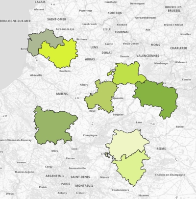
Pôles d'Équilibre Territorial et Rural (PETR) en Hauts-de-France
Périmètre des 8 Pôles d'Équilibre Territorial et Rural (PETR) dans la Région des Hauts-de-France.
Un pôle d’équilibre territorial et rural (PETR) est un établissement public regroupant plusieurs EPCI à fiscalité propre associés dans un périmètre territorial non enclavé sous la forme d’un syndicat mixte. Créés depuis 2014 ces structures permettent la coopération entre des territoires ruraux et des petites et moyennes villes.
Plus d'informations : https://www.vie-publique.fr/fiches/20134-les-poles-dequilibre-territoriaux-et-ruraux
Simple
- Date ( Creation )
- 2020-06-23
- Date ( Revision )
- 2020-12-01
- Identifier
- https://www.geo2france.fr/petr
- Maintenance and update frequency
- As needed
- Keywords ( Theme )
-
- POLE D'EQUILIBRE TERRITORIAL ET RURAL
- PETR
- EPCI
- POLITIQUE REGIONALE
- AMENAGEMENT DU TERRITOIRE
- COOPERATION
- ECONOMIE
- DEVELOPPEMENT ECONOMIQUE
- DONNEE OUVERTE
- Thèmes - SIG - HdF ( Theme )
-
- AMENAGEMENT
- GEMET - INSPIRE themes, version 1.0 ( Theme )
-
- Unités administratives
- Région ( Place )
-
- HAUTS-DE-FRANCE
- Départements ( Place )
-
- PAS-DE-CALAIS
- SOMME
- NORD
- OISE
- AISNE
- Use limitation
- Utilisation libre sous réserve de mentionner la source (a minima le nom du producteur) et la date de sa dernière mise à jour
- Use limitation
- Données ouvertes
- Use constraints
- Other restrictions
Spatial resolution
- Denominator
- 5000
- Metadata language
- fre
- Character set
- UTF8
- Topic category
-
- Boundaries
))
- Distribution format
-
-
(
)
-
(
)
- OnLine resource
-
Tableau de données PETR
(
WWW:LINK-1.0-http--link
)
Données brutes PETR (format xlsx)
- OnLine resource
-
Tableau de données PETR
(
WWW:LINK-1.0-http--link
)
Données brutes PETR (au format Csv) et encodage UTF-8
- OnLine resource
-
petr
(
OGC:WMS
)
Pôles d'Équilibre Territorial et Rural (PETR)
- OnLine resource
-
spld:petr
(
OGC:WFS
)
Pôles d'Équilibre Territorial et Rural (PETR)
- OnLine resource
-
Shapefile PETR
(
WWW:LINK-1.0-http--link
)
Shapefile PETR
- Hierarchy level
- Dataset
Conformance result
- Date ( Publication )
- 2020-06-20
- Explanation
- -- Information sur l'évaluation de la conformité (non INSPIRE) --
- Pass
- Statement
-
Périmètres des pôles d'équilibre territorial et rural (PETR) au 01/09/2019 avec contours simplifiés - GEOFLA® 2016
source : banatic https://www.banatic.interieur.gouv.fr/V5/accueil/index.php
- File identifier
- dc720470-bf16-4740-b665-6b1a7fbb4a33 XML
- Metadata language
- fr
- Character set
- UTF8
- Hierarchy level
- Dataset
- Hierarchy level name
- Précision sur le niveau de hiérarchie (non INSPIRE)
- Date stamp
- 2021-01-22T08:27:42
- Metadata standard name
- ISO 19115:2003/19139
- Metadata standard version
- 1.0
Overviews
Spatial extent
Provided by
