 Mon GéoSource
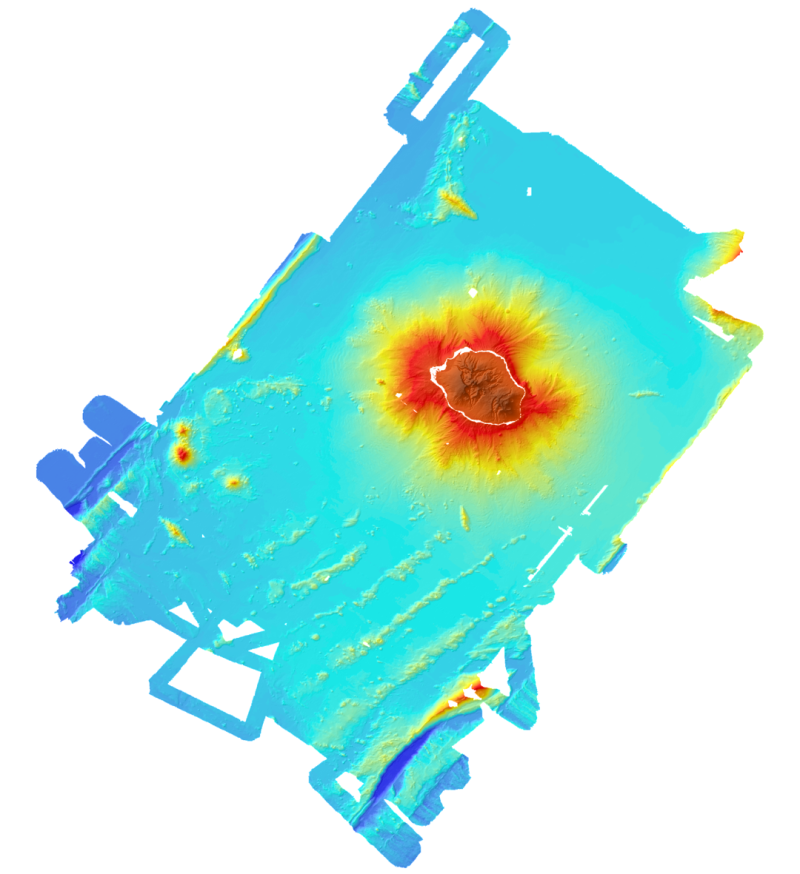
Bathy-morphology of the island of La Réunion - Campaigns Forever, Eroder 1 and 2 (DTM created in 2008; 300m resolution)
Bathymetric and topographic model of the island of La Réunion.
Topography is from IGN data.
Bathymetry is derived from the multibeam data acquired during the campaigns Forever (2006, EM12D sounder) Eroder1 (2006, EM120 sounder) and Eroder2 (2007, EM120 sounder).
The grid spacing is 300m.
Simple
- Alternate title
- IFR_MBAN_LAREUNION_300_01_R
- Alternate title
- fore_erod1et2 = IFR_MBAN_LAREUNION_300_01_R
- Date ( Creation )
- 2008-07-01T00:00:00
- Identifier
- FR-330-715-368-00032-IFR_MBAN_LAREUNION_300_01_R
- Presentation form
- Digital map
- Credit
- Ifremer, Geosciences Marines, 2008
- Status
- On going
- Maintenance and update frequency
- Not planned
- Thèmes Sextant Thèmes Sextant ( Theme )
-
- /Physical Environment/Bathymetry/Digital Terrain Model
- Keywords ( Theme )
-
- bathymetry
- Digital Terrain Model
- Keywords ( Place )
-
- La Réunion
- Indian Ocean
- Keywords ( Discipline )
-
- geophysics
- GEMET - INSPIRE themes, version 1.0 GEMET - INSPIRE themes, version 1.0 ( Theme )
-
- Elevation
- external.theme.gemet external.theme.gemet ( Theme )
-
- seabed
- underwater morphology
- Type de jeux de donnée ODATIS Type de jeux de donnée ODATIS ( Theme )
-
- /Processed data/Composite products
- Thématiques - SIMM Thématiques - SIMM ( Theme )
-
- /Etat du Milieu/Bathymétrie
- Sous-regions marines Sous-regions marines ( Place )
-
- /Outre-mer/Océan Indien
- Thématiques - SIMM Thématiques - SIMM ( Theme )
-
- Recherche
- Use limitation
- Commercial use is prohibited.
- Access constraints
- Other restrictions
- Use constraints
- License
- Other constraints
- Required citation : SAVOYE B., Ifremer, Eroder2 campaign, La Réunion, 2008
- Spatial representation type
- Grid
- Denominator
- 1000000
- Metadata language
- fr
- Character set
- UTF8
- Topic category
-
- Elevation
))
- Description
- period of data acquisition
- Begin date
- 2006-03-28T10:13:00
- End date
- 2008-01-16T10:14:00
- Reference system identifier
- EPSG / WGS 84 / World Mercator (EPSG:3395) / 7.4
- Number of dimensions
- 2
- Dimension name
- Column
- Dimension size
- 1849
- Resolution
- 300 m
- Dimension name
- Row
- Dimension size
- 2347
- Resolution
- 300 m
- Cell geometry
- Area
- Transformation parameter availability
- No
Distributor
- OnLine resource
- IFR_MBAN_LAREUNION_300_01_R ( OGC:WMS )
- Protocol
- COPYFILE
- OnLine resource
-
Campagne à la mer : FOREVER
(
WWW:LINK
)
Campagne à la mer : FOREVER
- OnLine resource
-
Campagne à la mer : ERODER 1
(
WWW:LINK
)
Campagne à la mer : ERODER 1
- OnLine resource
-
Campagne à la mer : ERODER 2 (METEOR 75-1A)
(
WWW:LINK
)
Campagne à la mer : ERODER 2
- Hierarchy level
- Dataset
- Description
- Vertical extent of the DTM
Vertical extent
- Minimum value
- -5709
- Maximum value
- 3019
Conformance result
- Date ( Creation )
- 2012-01-16
- Explanation
- not evaluated
- Pass
- No
- Statement
-
Bathymetry data acquired during campaigns Forever (2006 multibeam EM12D) Eroder1 (2006, EM120 multibeam) and Eroder2 (2007 EM120 multibeam sounder).
Topography data from IGN.
- Description
- Multibeam data processed by the software Caraïbes (Ifremer).
- Description
- Geodesy: WGS84 Mercator Projection at S21°
- File identifier
- 033cf816-eaf9-4eb5-a2fd-ade5b741564f XML
- Metadata language
- fr
- Character set
- UTF8
- Hierarchy level
- Dataset
- Date stamp
- 2021-05-25T10:57:37
- Metadata standard name
- ISO 19115:2003/19139 - SEXTANT
- Metadata standard version
- 1.0
Overviews
Spatial extent
Provided by
