 Mon GéoSource
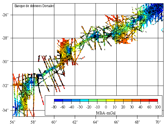
Grille d’anomalie de Bouguer réduite au manteau - dorsale Sud-Ouest Indienne 57°-70°E - 1600m
Simple
- Date ( Création )
- 2000-07-28
- Identificateur
- IFR_MBAN_DORSALES_INDIEN_SWIR57_70_GRAVI_MBA_1600_R
- Identificateur
- DOI:10.12770/05c72638-b555-47b7-ab0c-12e988968d51
- Reconnaissance
- Le projet s'inscrit dans le cadre du programme national Dorsales et représente la contribution française au projet Banques de données du programme InterRidge (cf. InterRidge News 1997,vol. 6/1 et 1999, vol. 8/1).
+33 (0)2 98.22.46.44
http://www.ifremer.fr/sismer/
- Thèmes Sextant Thèmes Sextant ( Thème )
-
- /Milieu physique/Géologie sédimentologie/Géomorphologie
- GEMET - INSPIRE themes, version 1.0 GEMET - INSPIRE themes, version 1.0 ( Thème )
-
- Caractéristiques géographiques océanographiques
- Type de jeux de donnée ODATIS Type de jeux de donnée ODATIS ( Thème )
-
- /Données dérivées/Produits composites
- Thématiques - SIMM Thématiques - SIMM ( Thème )
-
- /Etat du Milieu/Bathymétrie
- /Etat du Milieu/Géologie
- Sous-regions marines Sous-regions marines ( Localisation )
-
- /Outre-mer/Océan Indien
- Thématiques - SIMM Thématiques - SIMM ( Thème )
-
- Recherche
- Limitation d'utilisation
- CC-BY (Creative Commons - Attribution)
- Contraintes d'accès
- Autres restrictions
- Contraintes d'utilisation
- Licence
- Autres contraintes
- Rommevaux-Jestin C., Deplus C. and Patriat Ph., 1997 - Mantle Bouguer anomaly along a super-slow spreading ridge : comparison with Mid-Atlantic Ridge and implications on the accretionary processes - Mar. Geophys. Res., 19/5, 481-503.
- Type de représentation spatiale
- Raster
- Dénominateur de l'échelle
- 25000
- Langue
- fr
- Jeu de caractères
- Utf8
- Catégorie ISO
-
- Océans
))
- Date de début
- 1972-01-01
- Date de fin
- 1994-12-30
- Nom du système de référence
- EPSG / WGS 84 (EPSG:4326) / 8.6
- Dimensions
- 2
- Noms des axes
- Axe - X
- Résolution
- 1 minute
- Noms des axes
- Axe - Y
- Résolution
- 1 minute
- Type de raster
- Surface
- Ressource en ligne
-
IFR_MBAN_DORSALES_INDIEN_SWIR57_70_GRAVI_MBA_1600_R
(
OGC:WMS
)
Gravimétrie à 1600m de résolution
- Protocole
- FILE
- Nom
- IFR_MBAN_DORSALES_INDIEN_SWIR57_70_GRAVI_MBA_1600_R
- Description
- Gravimétrie 1600m - format .tif
- Ressource en ligne
-
DOI du jeu de données
(
WWW:LINK-1.0-http--metadata-URL
)
DOI du jeu de données
- Protocole
- COPYFILE
- Nom
- IFR_MBAN_DORSALES_INDIEN_SWIR57_70_GRAVI_MBA_1600_R
- Description
- Gravimétrie 1600m - format .grd
- Niveau
- Jeu de données
- Généralités sur la provenance
-
Source(s) des données : Compilations de données entre 1973-1994 et données du fichier mondial de Sandwell
Contrôle(s) qualité effectués : méthode de Chapman (1979) par calcul direct sur les points d’observation de la FAA, épaisseur de croûte 5 km, contraste de densité eau-croûte 1700 km/m3, croûte/manteau 600 kg/m3.
Logiciel de maillage utilisé : Surface de GMT
- Description
- Spline en tension (surface)
- But du processus
- Interpolation
- Description
- Précision de 3-5 mGal
- But du processus
- Masquage des données inexistantes avec grdmask
Information sur le contenu
- Identifiant de la fiche
- 05c72638-b555-47b7-ab0c-12e988968d51 XML
- Langue
- fr
- Jeu de caractères
- Utf8
- Type de ressource
- Jeu de données
- Date des métadonnées
- 2020-08-31T11:24:59
- Nom du standard de métadonnées
- ISO 19115:2003/19139 - SEXTANT
- Version du standard de métadonnées
- 1.0
Aperçus
Étendue spatiale
Fourni par
