 Mon GéoSource
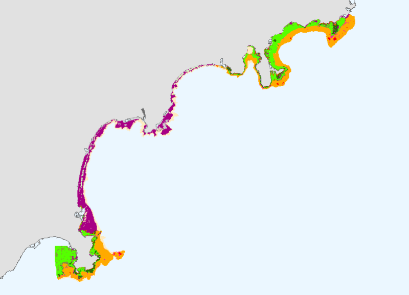
Cartographie des biocénoses marines entre Antibes et Cap d'Ail
Simple
- Autres appellations ou acronymes
- BIOMED_BIOC_ANTIBE_P
- Date ( Publication )
- 2007-07-01T00:00:00
- Identificateur
- BIOMED_BIOC_ANTIBE_P
- Forme de la présentation
- Carte numérique
- But
-
La cartographie des biocénoses marines entre Antibes et Cap d'Ail s'inscrit dans la démarche du contrat de baie. Commanditée par la CANCA, elle a été réalisée par L'Oeil d'Andromède d'Avril 2006 à mai 2007, avec la participation financière de l'Agence de l'Eau RM&C, la région PACA et le Conseil Général des Alpes Maritimes.
Cette cartographie a permis l'analyse de la vulnérabilité des biocénoses et propose, in fine, une série d'actions nécessaires à leur protection, leur valorisation et le cas échéant leur restauration.
- Reconnaissance
- Medbenth
- Etat
- Mise à jour continue
- Fréquence de mise à jour
- Lorsque nécessaire
- Thèmes Sextant Thèmes Sextant ( Thème )
-
- /Milieu biologique/Habitats
- Mots clés ( Thème )
-
- biocénoses
- habitat
- posidonie
- carte
- Mots clés ( Localisation )
-
- Méditerranée
- Antibes
- Cap d'Ail
- GEMET - INSPIRE themes, version 1.0 GEMET - INSPIRE themes, version 1.0 ( Thème )
-
- Habitats et biotopes
- Cadre Réglementaire - SIMM Cadre Réglementaire - SIMM ( Thème )
-
- Directive Cadre pour la Planification de l'Espace Maritime (DCPEM)
- Directive Cadre Stratégie pour le Milieu Marin (DCSMM)
- Type de jeux de donnée ODATIS Type de jeux de donnée ODATIS ( Thème )
-
- /Données dérivées/Produits composites
- Thématiques - SIMM Thématiques - SIMM ( Thème )
-
- /Etat du Milieu/Habitats
- Sous-regions marines Sous-regions marines ( Localisation )
-
- /Métropole/Méditerranée occidentale
- Limitation d'utilisation
- Ce produit numérique a été élaboré dans le cadre de la réalisation d'une synthèse des travaux cartographiques traitant des biocénoses benthiques et disponibles en Méditerranée. Ce travail a été réalisé en partenariat par l'Agence de l'eau Rhône Méditerranée & Corse et l'Ifremer. Les fichiers sont à usage personnel. Toute utilisation commerciale est strictement interdite.
- Contraintes d'accès
- Droit d’auteur / Droit moral (copyright)
- Contraintes d'utilisation
- Licence
- Autres contraintes
- Obligation de citation sur la carte: Communauté d'Agglomération Nice Côte d'Azur, Conseil Général des Alpes-Maritimes, Région PACA, Agence de l'Eau Rhône Méditerranée & Corse, Andromède Environnement
- Autres contraintes
- Obligation decitation dans la bibliographie: HOLON F., DESCAMP P., 2007. CARTOGRAPHIE ET ANALYSE DES BIOCENOSES MARINES ENTRE ANTIBES ET CAP D'AIL. Contrat Communauté d'Agglomération Nice-Côte d'Azur.
- Type de représentation spatiale
- Vecteur
- Dénominateur de l'échelle
- 5000
- Langue
- fr
- Jeu de caractères
- Utf8
- Catégorie ISO
-
- Océans
- Environnement
))
- Informations supplémentaires
-
L'atlas cartographique fait apparaître un littoral marqué par la proximité du massif alpin et présentant un profil varié de côtes basses, ainsi que de côtes rocheuses qui plongent directement dans la mer. En mer on retrouve cette géomorphologie complexe qui se traduit par une grande diversité biocénotique concentrée sur une surface restreinte du fait d'un plateau étroit. 7 fleuves, dont le Var, débouchent dans la zone et influent fortement sur les équilibres écologiques marins, du fait par exemple d'apports sédimentaires importants par temps de pluie.
Différentes méthodes d'acquisition de données ont été employées : une synthèse bibliographique des données existantes, des levers au sondeur multifaisceaux et sonar latéral, une cartographie des algues du médiolittoral, l'étude des photographies aériennes (IGN 1999 et 2004), des vérités terrain par transects plongeur audio et plongées ponctuelles, des prises de vue vidéo et photo.
Le référentiel utilisé comme trait de côte est celui des photographies aériennes de l'IGN.
HOLON F., DESCAMP P., 2007. CARTOGRAPHIE ET ANALYSE DES BIOCENOSES MARINES ENTRE ANTIBES ET CAP D'AIL. Contrat Communauté d'Agglomération Nice-Côte d'Azur.
- Nom du système de référence
- 4326
- Niveau topologie
- Géométrie seulement
- Type de géométries des objets
- Polygone
Distributeur
- Ressource en ligne
- BIOMED_BIOC_ANTIBE_P ( OGC:WMS )
- Niveau
- Jeu de données
- Généralités sur la provenance
- HOLON F., DESCAMP P., 2007. CARTOGRAPHIE ET ANALYSE DES BIOCENOSES MARINES ENTRE ANTIBES ET CAP D'AIL. Contrat Communauté d'Agglomération Nice-Côte d'Azur.
- Identifiant de la fiche
- 0e7a5090-57bf-11dd-a60f-000086f6a603 XML
- Langue
- fr
- Jeu de caractères
- Utf8
- Type de ressource
- Jeu de données
- Date des métadonnées
- 2020-06-04T00:46:25
- Nom du standard de métadonnées
- ISO 19115:2003/19139 - SEXTANT
- Version du standard de métadonnées
- 1.0
Aperçus
Étendue spatiale
Fourni par
