 Mon GéoSource
Données bathymétriques pour étude de dérisquage dans le Golfe du Lion
Ce lot de données bathymétriques est mis à disposition dans le cadre de l'étude de dérisquage à réaliser dans le Golfe du Lion pour l'attribution d'un Appel d'Offre "éolien flottant commercial" d'ici 2022.
Il regroupe des modèles numériques de bathymétrie couvrant uniquement les eaux territoriales françaises, et dont les données ont été acquises pendant les campagnes océanographiques : AM-MED-1, BASAR2, BASAR3, RHOSOS et STRATAFORM 1.
Simple
- Date ( Publication )
- 2020-12-10
- Identificateur
- FR-330715-368-00032-GDL_Package_AO_EOFCommercial_bathy
- Reconnaissance
- Ifremer
+33 (0)2 98.22.46.44
http://www.ifremer.fr/sismer/
+33 (0)2 98.22.46.44
http://www.ifremer.fr/sismer/
+33(0)2 98.22.45.70
http://www.ifremer.fr/drogm/
- Thèmes Sextant Thèmes Sextant ( Thème )
-
- /Milieu physique/Bathymétrie/MNT
- GEMET - INSPIRE themes, version 1.0 GEMET - INSPIRE themes, version 1.0 ( Thème )
-
- Altitude
- Ocean Hackathon - Ville Ocean Hackathon - Ville ( Localisation )
-
- Sète
- Limitation d'utilisation
- Licence Ouverte
- Contraintes d'accès
- Droit d’auteur / Droit moral (copyright)
- Contraintes d'utilisation
- Licence
- Autres contraintes
-
L'utilisateur s'engage à respecter les termes de la licence Etalab: https://www.etalab.gouv.fr/licence-ouverte-open-licence
et à citer les DOI suivants:
RABINEAU Marina, DROZ Laurence, ASLANIAN Daniel (2013) AM-MED-1 cruise, RV Le Suroît, https://doi.org/10.17600/18000821
BERNE Serge (1995) BASAR 2 cruise, RV L'Europe, https://doi.org/10.17600/95060080
MARSSET Tania (1998) BASAR 3 cruise, RV L'Europe, https://doi.org/10.17600/98060090
BERNE Serge, DENNIELOU Bernard (2008) RHOSOS cruise, RV Le Suroît, https://doi.org/10.17600/8020040
BERNE Serge (2002) STRATAFORM 1 cruise, RV Le Suroît, https://doi.org/10.17600/2020030
- Type de représentation spatiale
- Raster
- Langue
- fr
- Jeu de caractères
- Utf8
- Catégorie ISO
-
- Océans
))
- Date de début
- 1995-11-16
- Date de fin
- 2013-09-25
- Dimensions
- 2
- Noms des axes
- Axe - Z
- Noms des axes
- Temps
- Type de raster
- surface
- Disponibilité des paramètres de transformation
- Non
- Format (encodage)
-
-
Raster
(
)
-
Raster
(
)
- Ressource en ligne
- DOI campagne AM-MED 1 ( WWW:LINK )
- Ressource en ligne
- DOI campagne BASAR 2 ( WWW:LINK )
- Ressource en ligne
- DOI campagne BASAR 3 ( WWW:LINK )
- Ressource en ligne
- DOI campagne RHOSOS ( WWW:LINK )
- Ressource en ligne
- DOI campagne STRATAFORM 1 ( WWW:LINK )
- Protocole
- COPYFILE
- Nom
- Lien de téléchargement
- Fonction
- Téléchargement
- Niveau
- Jeu de données
Résultat de conformité
- Date ( Publication )
- 2010-12-08
- Explication
- See the referenced specification
- Généralités sur la provenance
- Les données fournies sont des modèles numériques de bathymétrie, au format GeoTIFF. Un fichier de métadonnée est disponible pour chaque bathymétrie.
- Identifiant de la fiche
- 1fa1c920-fef9-429d-91be-5680fe085f4d XML
- Langue
- fr
- Jeu de caractères
- Utf8
- Type de ressource
- Jeu de données
- Date des métadonnées
- 2021-06-14T14:38:51
- Nom du standard de métadonnées
- ISO 19115:2003/19139 - SEXTANT
- Version du standard de métadonnées
- 1.0
Aperçus
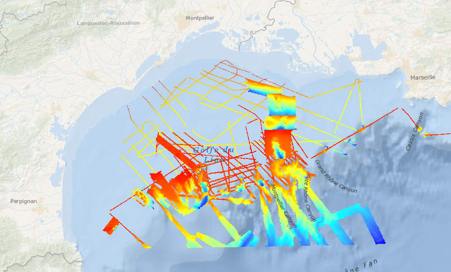
Étendue spatiale
Fourni par
