 Mon GéoSource
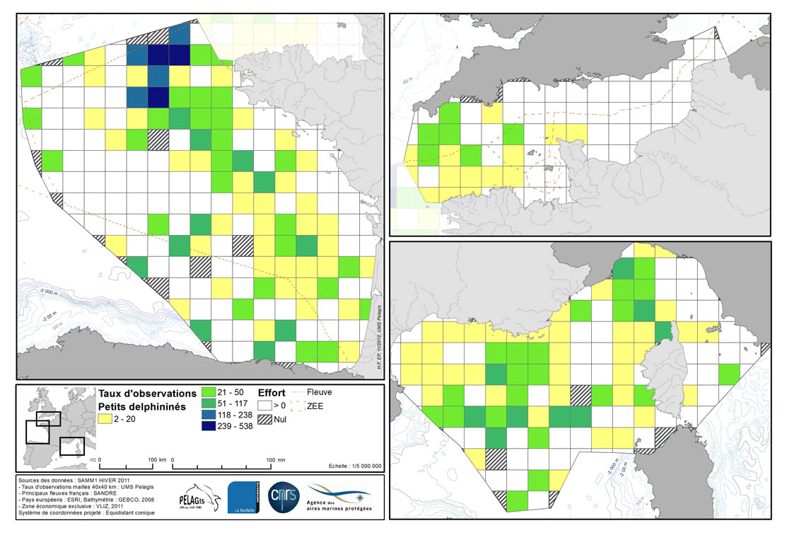
Observations visuelles sur plateforme aérienne dédiée - 4. Analyses, taux de rencontre (observation), maille 40km - Mammifère marin - PACOMM/SAMM1
Taux de rencontre en nombre d’observation pour 1000 km d’effort dans chaque maille de 40 km de la ZEE française métropolitaine en hiver 2011/2012 et été 2012.
Description de la table attributaire :
survey : campagne
type : type d'observation
maille : taillle de la maille en kilomètre
_no_maille : numéro de la maille
Les champs suivant correspondent au calcul de taux de rencontre du nombre d'observation pour 1000km d'effort pour chaque espèce ou groupe d'espèce :
- [marsouin] Marsouin commun
- [grdDauph] Grand dauphin
- [lagenor] Lagénorhynque à bec blanc
- [pttDelph] : dauphin commun + dauphin bleu et blanc
- [globiceph] : Globicephale noir + dauphin de Risso
- [cakobab] : cachalot macrocéphale + kogias + baleines à bec
- [balenopt] : rorqual commun + petit rorqual + baleine bleue
- [phoque] Phoques (gris + veau-marin)
Simple
- Autres appellations ou acronymes
- PELAGIS_2014_4_ANA_TXOBS_40_MM_OVIPA_SAMM1
- Date ( Création )
- 2014-12-04
- Identificateur
- FR_19170032700015_2670_PELAGIS_2014_4_ANA_TXOBS_40_MM_OVIPA_SAMM1
05 46 44 99 45
www.observatoire-pelagis.cnrs.fr
- Forme de la présentation
- Carte numérique
- But
- Produire un état des lieux de la distribution spatiale et de l'abondance de ces espèces et d’en évaluer la variabilité spatiale et temporelle afin d'alimenter une réflexion commune pour la désignation et gestion d’aires marines protégées.
- Reconnaissance
- Observatoire PELAGIS - UMS 3462, Agence des Aires Marines Protégées
- Etat
- En cours de création
- Fréquence de mise à jour
- Lorsque nécessaire
- Nom
- ESRI Shapefile
- Version
- 0.1
- Mots clés ( Thème )
-
- Observation
- Visuelle
- Aérien
- SAMM
- SAMM1
- Taux de rencontre
- Leg
- Mammifère marin
- Mots clés ( Localisation )
-
- France
- Métropole
- Manche
- Atlantique
- Golf de gascogne
- Méditerranée
- Mots clés ( Discipline )
-
- Natura 2000 en mer
- DCSMM
- Pelagos
- Directive habitat
- Directive oiseau
- GEMET - INSPIRE themes, version 1.0 GEMET - INSPIRE themes, version 1.0 ( Thème )
-
- Répartition des espèces
- Thèmes Sextant Thèmes Sextant ( Thème )
-
- /Milieu biologique/Espèces/Faune
- Thématiques - SIMM Thématiques - SIMM ( Thème )
-
- /Etat du Milieu/Espèces
- Type de jeux de donnée ODATIS Type de jeux de donnée ODATIS ( Thème )
-
- /Observations in-situ/Campagnes
- Cadre Réglementaire - SIMM Cadre Réglementaire - SIMM ( Thème )
-
- Directive Habitat, Faune et Flore
- Directive Cadre Stratégie pour le Milieu Marin (DCSMM)
- Sous-regions marines Sous-regions marines ( Localisation )
-
- /Métropole
- /Métropole/Golfe de Gascogne
- /Métropole/Manche mer du Nord
- /Métropole/Méditerranée occidentale
- /Métropole/Mers Celtiques
- DCSMM : Descripteurs DCSMM : Descripteurs ( Thème )
-
- D10: Déchets marins
- D1: Biodiversité
- D1: Biodiversité - Mammifères
- Utilisation
-
Présence en mer
Distribution en mer
Définition de l'abondance et distribution des mammifères marins,
Modélisation géostatistique
Modélisation d'habitats préférentiels
Natura 2000 en mer
Directive Cadre Stratégie Milieu Marin
Interaction avec les activités humaines
- Limitation des applications
- Toutes les observations n'ont de valeur quantitative que lorsqu'elles sont associées à l'effort d'observation exercé (nb d'observation/ temps d'observation)
05 46 44 99 45
05 46 44 99 45
- Limitation d'utilisation
- Utilisation à usage non commercial et sous réserve de mentionner la source (a minima le nom du producteur) et la date de sa dernière mise à jour
- Limitation d'utilisation
-
Les données d'occurrences témoignent de la présence des espèces (et non pas de leur distribution vraie) et non de leur absence car elles ne sont pas corrigées par l'effort d'observation. Toute interprétation sans analyse préalable et au delà des limites citées est donc sujette à caution.
Les données élémentaires d’échanges sont publiques (espèce, position, date, nom de campagne) et libres d’accès. Elles seront accessibles depuis le site de l’UMS 3462 en cours de réalisation ou directement sur le catalogue PELAGIS (Sextant).
L’utilisation de l'ensemble du jeu de données (paramètres d’observations et d’effort associé) devra faire l’objet d’une demande à l’Observatoire Pelagis et passe par le respect d'une charte d'utilisation des données produites par l'Observatoire.
Avertissement ! Toutes les observations relevées n’ont de valeur quantitative que lorsqu’elles sont associées à l’effort d’observation exercé sur un transect (n observations/n temps d’observation).
Il n'y a pas de données 'brutes' dans la mesure où elles ont été validées, corrigées d’un point de vue technique et scientifique.
- Contraintes d'accès
- Droit de propriété intellectuelle / Droit patrimonial
- Contraintes d'utilisation
- Droit d’auteur / Droit moral (copyright)
- Contraintes d'utilisation
- Autres restrictions
- Autres contraintes
-
Obligation de citation "UMS 3462, Observatoire PELAGIS - AAMP, 'Nom de jeu de données'"
Obligation de prise de contact pour tout usage, toute publication scientifique et/ou "coauthorship" si jugé nécessaire par les propriétaires
- Type de représentation spatiale
- Vecteur
- Dénominateur de l'échelle
- 1000000
- Distance de résolution
- 100 mètre
- Langue
- fr
- Jeu de caractères
- Utf8
- Catégorie ISO
-
- Biote
- Description de l'environnement de travail
- FME 2013+, Arcgis 10+, Access 2003, VOR, Windows 7
))
- Date de début
- 2011-12-01T00:00:00
- Date de fin
- 2012-01-29T00:00:00
- Informations supplémentaires
- - Métadonnée en cours de rédaction -
- Nom du système de référence
- 4326
- Niveau topologie
- Géométrie seulement
- Type de géométries des objets
- Complexe
- Nombre d'objets géométriques
- 6
- Ressource en ligne
-
PELAGIS_OBS_MARSOUIN_PACOMM_SAMM1_P
(
OGC:WMS
)
Marsouins
- Ressource en ligne
-
PELAGIS_OBS_GRAND_DAUPHIN_PACOMM_SAMM1_P
(
OGC:WMS
)
Grands dauphins
- Ressource en ligne
-
PELAGIS_OBS_PETIT_DELPHINE_PACOMM_SAMM1_P
(
OGC:WMS
)
Petits delphinés
- Ressource en ligne
-
PELAGIS_OBS_GLOBICEPHALINES_PACOMM_SAMM1_P
(
OGC:WMS
)
Globicephalinés
- Protocole
- FILE
- Nom
- PELAGIS_OBS_ALL_SPECIES_PACOMM_SAMM1_P
- Niveau
- Jeu de données
- Généralités sur la provenance
-
- Données issues d'un protocole de collecte et de validation : Guide méthodologique des campagnes aériennes d’observation des oiseaux et mammifères marins sur l’espace maritime métropolitain et zones limitrophes – Programme PACOMM - SAMM. G.Dorémus et al. 2011.
- Le protocole d’acquisition de ces données sur ces campagnes a été mis en place grâce à l’expérience de l’équipe de l’Observatoire PELAGIS acquise depuis plus de 10 ans dans ce domaine notamment à travers les campagnes d’observations aériennes ROMER( 2000-2002), ATLANCET (2003) et SCANS (2005)
Les observations sont faites depuis un avion survolant des transects prédéfinis, à une hauteur constante de 600 pieds et à une vitesse de 90 nœuds. Deux observateurs relèvent les conditions environnementales et les observations suivantes (en surface ou sous la surface):
- selon la méthode de strip transect (bande de 200m): les observations d'oiseaux
- selon la méthode du line transect (jusqu'à 500m): les observations de mammifères marins, de requins, raies, poissons osseux (grands poissons ou bancs de poisson) et tortues marines.
- selon la méthode de strip transect : les macro-déchets (bande de 200 m) et les bateaux (bande de 500m)
Les données sont collectées sous la coordination de l'Observatoire PELAGIS par des équipes de scientifiques et des observateurs, tous formés spécifiquement au protocole d’observation aérienne mis en place dans le cadre de ces programmes (protocole identique sur REMMOA et SAMM).
Bilan : Les campagnes SAMM ont permis de collecter plus de 80 000 données de même nature dans les eaux métropolitaines le long de plus de 100 000 km de transects.
Les campagnes REMMOA ont permis de collecter plus de 55 000 observations sur la mégafaune marine et les activités humaines (déchets, navires et engins de pêche) sur près de 205 000 km de transects parcourus en avion au-dessus de la mer.
- Les survols réalisés en métropole - campagne SAMM (Suivi de la Mégafaune Marine) - s'inscrivent dans le programme PACOMM répondant aux objectifs communautaires de conservation et de valorisation des espaces maritimes (Natura 2000, DCSMM, conventions de mer régionales…).
Le jeu de données est composé de deux jeux de données samm1 pour l'hiver 2011 et samm2 pour l'été 2012.
- Description
-
Pour chaque région d'étude est associée au moins une campagne. Les observateurs sont liés à la campagne ainsi que les secteurs géographiques d'étude. Pour chaque secteur sont associées des strates bathymétriques et des transects liés à chacune de ces strates (à quelques exceptions près pour la région Océan Indien).
- Définition des secteurs : zones correspondant aux domaines maritimes distincts (façade, archipel, etc.)
- Définition des strates bathymétriques : zones au sein de chaque secteur, délimitées en fonction des caractéristiques bathymétriques telles que la profondeur, le relief et le gradient de pente
- Définition des transects : la ventilation de l’effort d’observation entre les strates bathymétriques a été définie en tenant compte des taux d’observations attendus (disponibles dans la littérature ou issus de campagnes précédentes non publiées) afin d’obtenir un nombre significatif d’observations pour les cétacés et de permettre une modification de l’effort au cours de la campagne en fonction des taux réellement observés (augmentation ou diminution de l’effort). Les transects suivent une disposition systématique au sein d’une strate.
- But du processus
- PLAN D'ECHANTILLONNAGE
- Description
-
Les données sont acquises pendant les vols et sont également enregistrées numériquement.
A terre, les données sont nettoyées des oublis et erreurs de saisie.
La correspondance code espèce, nom, famille, genre a été vérifiée avec le référentiel TAXREFv5.0. L'identification des espèces est affinée par les photos prises le cas échéant.
Les données sont restées dans leur système de coordonnées initial.
Les données sont acquises dans le cadre d'un protocole défini depuis l'acquisition (formation des observateurs) à la validation technique et scientifique et supervisées par les scientifiques de l'Observatoire PELAGIS.
- But du processus
- ACQUISITION
- Description
-
Au retour de campagne, les données subissent un contrôle et une revalidation technique et scientifique par les experts de l'Observatoire Pelagis.
L'effort est ensuite linéarisé et comptabilisé afin de déterminer les taux de rencontre (nombre d'observation/km d'effort parcourus)
Les données d'occurrences sont générées et mises à disposition sur le portail du GBIF et à disposition sur bancarisées dans le système d'information de l'Observatoire PELAGIS
Les données sont à l'heure actuelle stockées dans leur format natif (VOR - Access) et en Géodatabase fichier (ESRI 2012).
Il s'agit du niveau 0 des données, c'est à dire, du niveau de base.
- But du processus
- POST-TRAITEMENT
- Description
-
Les données subissent un contrôle qualité automatisé sous FME 2013+.
Il s'agit du niveau 1 des données, c'est à dire du niveau validé où l'effort est linéarisé et relié aux observations.
- But du processus
- CONTROLE QUALITE
- Description
-
Les données sont préparées pour les analyses (ajout d'identifiants, découpage de l'effort en segments homogènes, etc.)
Les analyses sont réalisées conjointement sous R et sous Distance.
Il s'agit du niveau 2 des données, c'est à dire du niveau élaboré, ce format des données n'est pas public.
- But du processus
- ANALYSES
- Description
-
Les taux de rencontre sont calculés pour chaque espèce ou regroupement d'espèces (tels que définis dans les rapports de campagne SAMM 1 et SAMM 2) et pour chaque campagne. Il s'agit des taux de rencontre en nombre d’observation dans chaque maille de la zone d'étude.
Pour calculer ces taux, la première étape consiste à calculer l'effort d'observation réalisé dans chaque maille. La seconde étape est de calculer le nombre d'observations en effort (hors observation en transit, etc.) obtenues dans chaque maille. Le taux de rencontre est le rapport du nombre d'observations réalisées sur le nombre de kilomètres d'effort d'observation, ramené à 1000 km d'effort par une simple règle de trois.
On ne tient pas compte du nombre d'individus observés, mais uniquement du nombre de « contacts » avec une espèce ou un groupe d’espèce (c’est-à-dire que l’on considère l’observation comme unité de comptage, qu’il y ait un seul ou des centaines d’individus dans le groupe observé).
Les taux sont calculés selon les taxons pour deux niveaux de résolution différents: un maillage 40 x 40 km sur l'ensemble des quatre strates (côtier C, néritique N, pente P et océanique O), un maillage 15 x 15 km sur l'emprise de la strate côtière (on prend alors en compte les observations et l'effort de la strate côtière et de la portion des transects néritique qui se trouvent dans cette emprise). Ce second maillage a pour objectif de présenter les données avec plus de détail dans les eaux territoriales où se situent la majorité des aires protégées existantes.
- But du processus
- TAUX DE RENCONTRE
- Inclus dans le jeu de données
- Non
- Référence du catalogue d'objet
- Identifiant de la fiche
- 35372abf-db1b-42ac-be3e-48febec97b85 XML
- Langue
- fr
- Jeu de caractères
- Utf8
- Identifiant de la fiche de métadonnées parent
- 50e5008f-063b-4310-ab32-fd9c7228b42c 50e5008f-063b-4310-ab32-fd9c7228b42c
- Type de ressource
- Collection de données
- Date des métadonnées
- 2021-02-08T14:50:04
- Nom du standard de métadonnées
- ISO 19115:2003/19139 - SEXTANT
- Version du standard de métadonnées
- 1.0
05 46 44 99 45
Aperçus
Étendue spatiale
Fourni par
