 Mon GéoSource
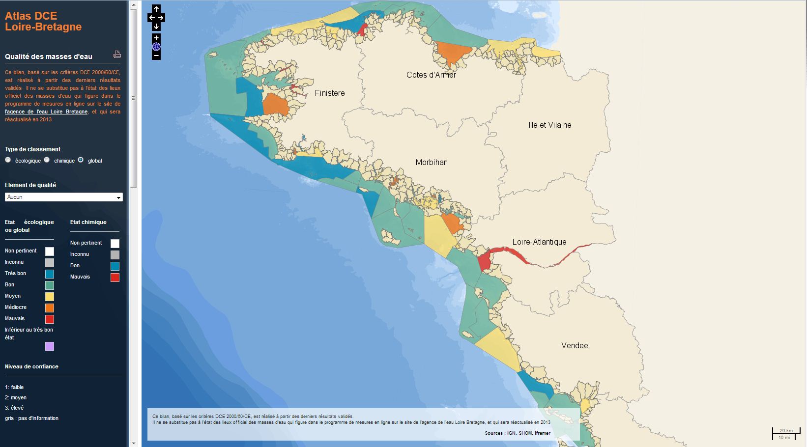
WFD - Loire-Bretagne Basin - Global status
The analysis concerns the assessment of the overall state of the coastal and transitional waters of the Western Channel and the Bay of Biscay. It results from the combination of the ecological status and the chemical status of each water body according to the rules of the European Water Framework Directive (WFD).
The most recent assessment of the state is presented in the DCE Loire-Bretagne atlas. Earlier reports are available in annual archives.
Simple
- Date ( Creation )
- 2014-01-01T00:00:00
- Identifier
- FR-33071536800297-ATLAS_DCE_LOIRE_BRETAGNE_ETATGLOBAL
- Credit
- DCE 2000/60/CE
- Status
- On going
- Maintenance and update frequency
- As needed
- Keywords ( Theme )
-
- DCE
- Données ouvertes
- Open Data
- GEMET - INSPIRE themes, version 1.0 GEMET - INSPIRE themes, version 1.0 ( Theme )
-
- Environmental monitoring facilities
- Thèmes Sextant Thèmes Sextant ( Theme )
-
- /Biological Environment/Habitats
- Sous-regions marines Sous-regions marines ( Place )
-
- Bay of Biscay
- Celtic Seas
- DCSMM : Descripteurs DCSMM : Descripteurs ( Theme )
-
- D1: Biodiversity
- Cadre Réglementaire - SIMM Cadre Réglementaire - SIMM ( Theme )
-
- Directive Cadre pour la Planification de l'Espace Maritime (DCPEM)
- Directive Cadre Stratégie pour le Milieu Marin (DCSMM)
- Thématiques - SIMM Thématiques - SIMM ( Theme )
-
- /Etat du Milieu/Biogéochimie
- /Etat du Milieu/Habitats
- /Etat du Milieu/Géologie
- Type de jeux de donnée ODATIS Type de jeux de donnée ODATIS ( Theme )
-
- /Processed data/Indicators
- Cadre Réglementaire - SIMM Cadre Réglementaire - SIMM ( Theme )
-
- Directive Cadre sur l'Eau (DCE)
- Access constraints
- Other restrictions
- Other constraints
-
Le bilan est basé sur les critères DCE 2000/60/CE et réalisé à partir des résultats validés annuellement.
Il ne se substitue pas à l'état des lieux officiel en ligne sur le site de l'agence de l'eau Loire-Bretagne
- Use limitation
- Aucune condition ne s’applique
- Spatial representation type
- Vector
- Denominator
- 10000
- Metadata language
- fr
- Character set
- UTF8
- Topic category
-
- Oceans
))
- Reference system identifier
- EPSG / NTF (Paris) / Lambert zone II (EPSG:27572) / 7.9
- Topology level
- Geometry only
- Geometric object type
- Surface
- Geometric object count
- 69
- Distribution format
-
-
ESRI Shapefile
(
1.0
)
-
ESRI Shapefile
(
1.0
)
- OnLine resource
-
atlas DCE Loire - Bretagne
(
WWW:LINK
)
atlas interactif pour visualiser la qualité des eaux littorales du bassin Loire - Bretagne
- OnLine resource
-
ATLAS_DCE_LOIRE_BRETAGNE_ME_ETAT_GLOBAL_2010_P
(
OGC:WMS
)
2010
- OnLine resource
-
ATLAS_DCE_LOIRE_BRETAGNE_ME_ETAT_GLOBAL_2010_P
(
OGC:WFS
)
2010
- OnLine resource
-
ATLAS_DCE_LOIRE_BRETAGNE_ME_ETAT_GLOBAL_2011_P
(
OGC:WMS
)
2011
- OnLine resource
-
ATLAS_DCE_LOIRE_BRETAGNE_ME_ETAT_GLOBAL_2011_P
(
OGC:WFS
)
2011
- OnLine resource
-
ATLAS_DCE_LOIRE_BRETAGNE_ME_ETAT_GLOBAL_2012_P
(
OGC:WMS
)
2012
- OnLine resource
-
ATLAS_DCE_LOIRE_BRETAGNE_ME_ETAT_GLOBAL_2012_P
(
OGC:WFS
)
2012
- OnLine resource
-
ATLAS_DCE_LOIRE_BRETAGNE_ME_ETAT_GLOBAL_2013_P
(
OGC:WMS
)
2013
- OnLine resource
-
ATLAS_DCE_LOIRE_BRETAGNE_ME_ETAT_GLOBAL_2013_P
(
OGC:WFS
)
2013
- Hierarchy level
- Dataset
Conformance result
- Date ( Creation )
- 2012-01-16
- Explanation
- Non évalué
- Pass
- No
- Statement
-
évaluation à partir des indicateurs de la DCE 2000/60/CE appliqués aux résultats du suivi du contrôle de surveillance annuelle.
données chimiques, biologiques et physico-chimiques issues de la base Quadrige ². Les données hydromorphologiques sont issues du SIG Eurosion (2003) à partir de la mise à jour du trait de côte de la base de données « CORINE Erosion Cotière » (1987 -1990), et du serveur cartographique en ligne Géoportail.
- File identifier
- 44898c09-9324-499b-8e51-82b7a80410ab XML
- Metadata language
- fr
- Character set
- UTF8
- Hierarchy level
- Series
- Date stamp
- 2020-06-04T00:25:51
- Metadata standard name
- ISO 19115:2003/19139 - SEXTANT
- Metadata standard version
- 1.0
Overviews
Spatial extent
Provided by
