 Mon GéoSource
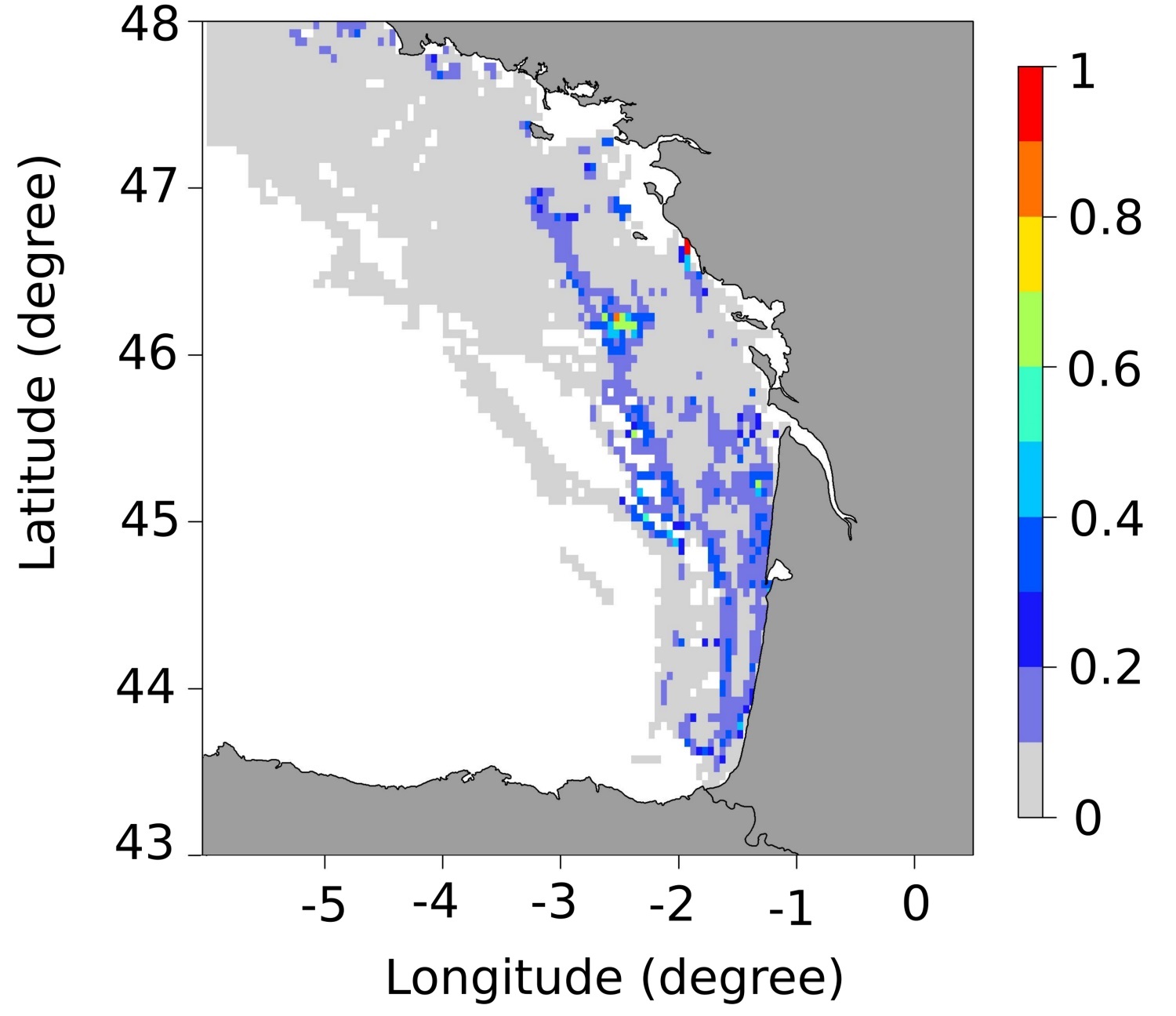
Frayères de bar (Dicentrarchus labrax) dans le golfe de Gascogne
Simple
- Date ( Publication )
- 2020-12-20
- Identificateur
- DOI:10.12770/4ca9f42a-af88-4a00-a553-32130a1b23a2
- Reconnaissance
- IFREMER - STH - LBH
- Thèmes Sextant Thèmes Sextant ( Thème )
-
- /Milieu biologique/Espèces/Espèces d'intérêt halieutique
- GEMET - INSPIRE themes, version 1.0 GEMET - INSPIRE themes, version 1.0 ( Thème )
-
- Habitats et biotopes
- Mots clés
-
- seabass
- sea bass
- essential fish habitat
- zone fonctionnelle
- Limitation d'utilisation
- CC-BY-NC-ND (Creative Commons - Attribution, Pas d’utilisation commerciale, Pas de modification)
- Contraintes d'accès
- Licence
- Contraintes d'utilisation
- Licence
- Type de représentation spatiale
- Vecteur
- Dénominateur de l'échelle
- 5000
- Langue
- en
- Jeu de caractères
- Utf8
- Catégorie ISO
-
- Océans
))
- Code
- EPSG:4326
- Type de géométries des objets
- Polygone
- Format (encodage)
-
-
(
)
-
(
)
- Ressource en ligne
-
Publication principale
(
WWW:LINK-1.0-http--publication-URL
)
Dambrine, C., Woillez, M., Huret, M., & de Pontual, H. (2021). Characterising Essential Fish Habitat using spatio‐temporal analysis of fishery data: A case study of the European seabass spawning areas. Fish Oceanogr, 30: 413-428. https://doi.org/10.1111/fog.12527
- Ressource en ligne
-
DOI de la donnée
(
WWW:LINK-1.0-http--metadata-URL
)
DOI de la donnée
- Ressource en ligne
-
IFR_STH_FRAYERES_BAR_GOLFE_DE_GASCOGNE_JANVIER
(
OGC:WMS
)
Frayères du bar - Janvier
- Ressource en ligne
-
IFR_STH_FRAYERES_BAR_GOLFE_DE_GASCOGNE_JANVIER
(
OGC:WFS
)
Frayères du bar - Janvier
- Ressource en ligne
-
IFR_STH_FRAYERES_BAR_GOLFE_DE_GASCOGNE_FEVRIER
(
OGC:WMS
)
Frayères du bar - Février
- Ressource en ligne
-
IFR_STH_FRAYERES_BAR_GOLFE_DE_GASCOGNE_FEVRIER
(
OGC:WFS
)
Frayères du bar - Février
- Ressource en ligne
-
IFR_STH_FRAYERES_BAR_GOLFE_DE_GASCOGNE_MARS
(
OGC:WMS
)
Frayères du bar - Mars
- Ressource en ligne
-
IFR_STH_FRAYERES_BAR_GOLFE_DE_GASCOGNE_MARS
(
OGC:WFS
)
Frayères du bar - Mars
- Ressource en ligne
-
IFR_STH_FRAYERES_BAR_GOLFE_DE_GASCOGNE_MOYENNE
(
OGC:WMS
)
Frayères du bar - Moyenne
- Ressource en ligne
-
IFR_STH_FRAYERES_BAR_GOLFE_DE_GASCOGNE_MOYENNE
(
OGC:WFS
)
Frayères du bar - Moyenne
- Niveau
- Jeu de données
Résultat de conformité
- Date ( Publication )
- 2010-12-08
- Explication
- See the referenced specification
- Généralités sur la provenance
-
Ces données ont été produites lors d'une thèse menée dans le cadre du projet Barfray financé par le Fonds Européen pour la Pêche et la Mer (FEAMP-OSIRIS N° : PFEA 400017DM0720006), France Filière Pêche (FFP), le Ministère français de l'Agriculture et de l'Alimentation (MAF) et l'Ifremer.
L'idée était d'améliorer les connaissances disponibles sur les frayères de bar européen (Dicentrarchus labrax) en Atlantique nord-est. Pour cela, nous avons caractérisé les frayères de bar le long de la côte atlantique française (Manche et Golfe de Gascogne) en utilisant des données de pêche de navires géolocalisés (données VMS fournies par la Direction des Pêches Maritimes et de l'Aquaculture (DPMA) et le Système d'Informations Halieutiques (SIH) de l'Ifremer). Une approche de géostatistique non-linéaire a été menée, sur les années 2008-2013, pour détecter les endroits où les bars s'agrègent pour se reproduire. Des cartes d'occurrence de frayères ont été produites pour les mois de la période de reproduction. Ces cartes d'occurrence ont été combinées en cartes moyennes représentant la probabilité mensuelle d'être une frayère. Ces cartes permettent de quantifier la variabilité saisonnière et interannuelle, et de mettre en évidence les zones de reproduction récurrentes, occasionnelles et défavorables. Une carte moyenne sur tous les mois de la période de reproduction a également été produite, permettant une synthèse des résultats et une utilisation simplifiée.
- Identifiant de la fiche
- 4ca9f42a-af88-4a00-a553-32130a1b23a2 XML
- Langue
- en
- Jeu de caractères
- Utf8
- Identifiant de la fiche de métadonnées parent
- 7bbdd386-21dc-47cd-a4af-4f4c7583663b 7bbdd386-21dc-47cd-a4af-4f4c7583663b
- Type de ressource
- Jeu de données
- Date des métadonnées
- 2022-03-16T15:21:12.551Z
- Nom du standard de métadonnées
- ISO 19115:2003/19139 - SEXTANT
- Version du standard de métadonnées
- 1.0
Aperçus
Étendue spatiale
Fourni par
