 Mon GéoSource
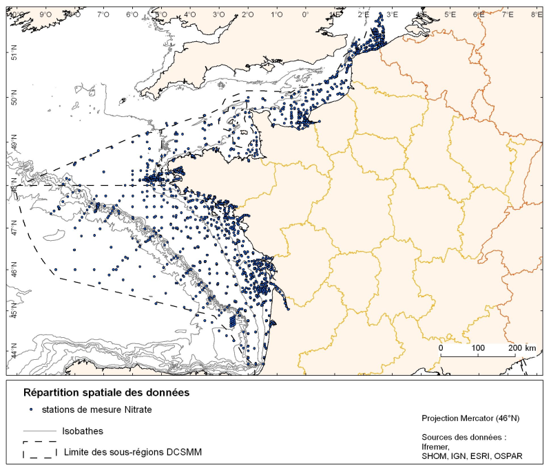
Distribution spatiale de l'ensemble des stations des données pour divers nutriments en Manche-Atlantique (silicate, nitrate, nitrite, ammonium et phosphate)
Répartition spatiale de données de nutriments (silicate, nitrate, nitrite, ammonium et phosphate) pour l'ensemble des sous régions maritime de la Manche-Mer du Nord, des mers Celtiques et du Golfe de Gascogne.
L'étendue temporelle des données va de 1930 à 2010, la plupart se situant entre les années 1974 et 2007 avec un maximum en 1999.
Simple
- Autres appellations ou acronymes
- SLCA, NTRA, NTRI, AMMO,PHOS
- Date ( Création )
- 2011-06-01
- Date ( Publication )
- 2011-06-01
- Identificateur
- SLCA, NTRA, NTRI, AMMO, PHOS
- Reconnaissance
- Ifremer
02 98 22 45 48
- Thèmes Sextant Thèmes Sextant ( Thème )
-
- /Activités humaines/Activités scientifiques
- Mots clés ( Thème )
-
- concentration
- nutriments
- climatologie mensuelle
- GEMET - INSPIRE themes, version 1.0 GEMET - INSPIRE themes, version 1.0 ( Thème )
-
- Caractéristiques géographiques océanographiques
- Mots clés ( Localisation )
-
- Manche
- Gascogne
- Contraintes d'accès
- Droit d’auteur / Droit moral (copyright)
- Contraintes d'utilisation
- Droit d’auteur / Droit moral (copyright)
- Restrictions de manipulation
- Non classifié
- Type de représentation spatiale
- Raster
- Distance de résolution
- 111120 metre
- Langue
- fr
- Jeu de caractères
- Utf8
- Catégorie ISO
-
- Informations géoscientifiques
))
- Date de début
- 1930-01-01T16:08:00
- Date de fin
- 2010-01-01T16:08:00
- Informations supplémentaires
-
L'ensemble des échantillons provient de prélèvements réalisés avec des bouteilles Niskin à différentes profondeurs, puis analysés en laboratoire. Les paramètres conservés dans la base et analysés sont :
− nitrate: NTRA (µmol/L)
− nitrite: NTRI (µmol/L)
− silicate: SLCA (µmol/L)
− ammonium: AMMO (µmol/L)
− phosphate: PHOS (µmol/L)
- Nom du système de référence
- EPSG / WGS84 géographiques / 7.4
- Format (encodage)
-
-
fichiers de formes ESRI
(
ArcGIS 9.3.1
)
-
fichiers de formes ESRI
(
ArcGIS 9.3.1
)
- Ressource en ligne
- site internet Ifremer dédié à la Directive Cadre Stratégie pour le Milieu Marin ( WWW:LINK )
- Ressource en ligne
-
carthothèque DCSMM
(
WWW:LINK
)
Répartition spatio-temporelle des nutriments
- Niveau
- Jeu de données
- Généralités sur la provenance
-
Les données sont issues de bases personnelles de scientifiques (données non encore enregistrées dans les bases de référence, ex: campagnes Modycot) et de bases de données nationales et
internationales (ICES, SDN, QUADRIGE2) qui représentent la majeure partie des données. Il y a cependant dans ces bases des données non validées ou sous moratoire (ces données ne sont
donc pas utilisées dans l'étude).
- Identifiant de la fiche
- 4d6d643d-e52e-4cf0-9840-ec2d3d7688df XML
- Langue
- fr
- Jeu de caractères
- Utf8
- Type de ressource
- Collection de données
- Nom du niveau de hiérarchie
- Ensemble de jeux de données
- Date des métadonnées
- 2020-06-04T00:50:35
- Nom du standard de métadonnées
- ISO 19115:2003/19139 - SEXTANT
- Version du standard de métadonnées
- 1.0
Aperçus
Étendue spatiale
Fourni par
