 Mon GéoSource
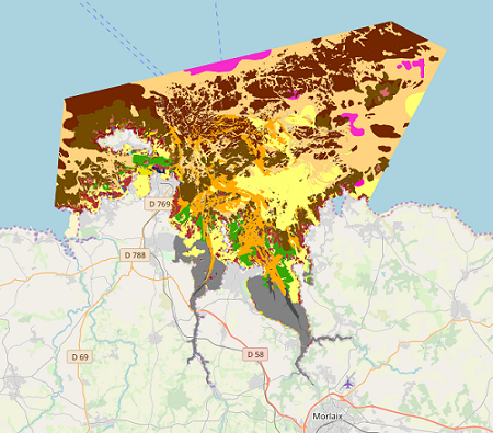
Carte de synthèse des habitats benthiques du site Natura 2000 FR5300015 - Baie de Morlaix
Simple
- Autres appellations ou acronymes
- BMO_Synthèse_Natura_Habitats_ZSC_V1r0
- Date ( Révision )
- 2019-03-15T00:00:00
- Date ( Publication )
- 2019-01-01
- Identificateur
- FR-330-715-368-00032-SYNTHESE_NATURA2000_FR5300015_MORLAIX
- Identificateur
- DOI:10.12770/57a9280a-caca-4e89-b2a0-52a2b85f8d5a
- Forme de la présentation
- Carte numérique
- But
- L'objectif de cette production est la caractérisation cartographique des habitats benthiques intertidaux et subtidaux de la Zone Spéciale de Conservation du site Natura 2000 de la baie de Morlaix.
- Reconnaissance
- Natura 2000
- Etat
- Mise à jour continue
0298224548
- Fréquence de mise à jour
- Non planifiée
- Thèmes Sextant Thèmes Sextant ( Thème )
-
- /Milieu biologique/Habitats
- Mots clés ( Thème )
-
- Habitat
- Benthique
- Natura 2000
- Données ouvertes
- Open Data
- Mots clés ( Localisation )
-
- Bretagne
- Baie de Morlaix
- GEMET - INSPIRE themes, version 1.0 GEMET - INSPIRE themes, version 1.0 ( Thème )
-
- Habitats et biotopes
- Type de jeux de donnée ODATIS Type de jeux de donnée ODATIS ( Thème )
-
- /Données dérivées/Produits composites
- Thématiques - SIMM Thématiques - SIMM ( Thème )
-
- /Etat du Milieu/Habitats
- Sous-regions marines Sous-regions marines ( Localisation )
-
- /Métropole/Mers Celtiques
- Ocean Hackathon - Ville Ocean Hackathon - Ville ( Localisation )
-
- Brest
- Limitation d'utilisation
- Limitation d'utilisation : Utilisation interdite pour un usage commercial. Toute modification de cette donnée est soumise à une autorisation préalable. Pour cela veuillez prendre contact avec le laboratoire LEBCO de l'Unité DYNECO de l'Ifremer.
- Contraintes d'accès
- Autres restrictions
- Contraintes d'utilisation
- Droit d’auteur / Droit moral (copyright)
- Autres contraintes
-
Dans la bibliographie et sur les cartes, citation obligatoire de la référence suivante :
Bajjouk T., Hamdi A., Bernard M., 2019. Carte de synthèse des habitats benthiques côtiers du site Natura 2000 FR5300015 - Baie de Morlaix. Produit Ifremer/Dreal Bretagne multi-sources Rebent/Natura2000/Cartham.
- Type de représentation spatiale
- Vecteur
- Dénominateur de l'échelle
- 5000
- Langue
- fr
- Jeu de caractères
- Utf8
- Catégorie ISO
-
- Biote
- Description de l'environnement de travail
- ArcGIS 10.0 SP3
))
- Date de début
- 2000-01-01
- Date de fin
- 2013-12-31
- Informations supplémentaires
-
Pour sa cartographie, ce site a été découpé en cinq zones prises en charge par :
- l'IFREMER dans le cadre du Rebent pour une partie intertidale (Ronan Loarer et Claire Rollet / secteur de Terenez / observations terrain entre 2008 et 2009) et pour une partie subtidale (Axel Ehrhold et al., entre 2008 et 2010)
- le LEMAR dans le cadre de Natura 2000 pour une partie intertidale (Stevenn Lamarche / les deux estuaires et l’est de la baie / observations terrain en 2010)
- le bureau d’études TBM dans le cadre de CARTHAM pour une partie subtidale (en partenariat avec Hocer, en 2011) et dans le cadre de Natura 2000 pour une partie intertidale (ouest de la baie, observations terrain en 2013)
Elle résulte à la fois de l'interprétation d'images acoustiques (sondeur multifaisceau, sonar à balayage latéral, RoxAnn) et aériennes (ortholitorales 2000, imagerie blom de 2008), de vidéos sous-marines, de prélèvements biosédimentaires et de validations terrain à pied et en bateau (observations, relevés GPS, photographies, etc.) réalisés entre 2008 et 2013. Les vides ont été comblés par interprétation lorsque des données bathymétriques et des images satellites étaient disponibles, ou par extrapolation.
La carte de synthèse des habitats benthiques du site Natura 2000 de la Baie de Morlaix est accompagnée d’une carte d’indices de confiance issue des outils du projet MESH permettant d’évaluer sa fiabilité. Les indices s’étendent de 41% à 95% en fonction de la méthode d’acquisition des données (>74% : fiabilité très élevée). Cette carte de synthèse est également complétée par une carte du schorre [Partie 2/3] et par une carte des aménagements humains présents sur la zone intertidale du site Natura 2000 [Partie 3/3].
Les typologies d'habitats utilisées sont celle du Cahiers d'habitats Natura 2000 et celle des habitats marins benthiques issue du Rebent.
Avertissement : l'Ifremer se dégage de toute responsabilité concernant la qualité thématique des données. Celle-ci reste la responsabilité des auteurs.
REFERENCES
Bajjouk T., 2009. Cahier des charges pour la cartographie d’habitats des sites Natura 2000 littoraux. Guide méthodologique. Ref. RST/IFREMER/DYNECO/AG/09‐01/TB, 107 p.
Bajjouk T., Derrien S., Gentil, F., Hily C. & Grall J., 2010. Typologie d’habitats marins benthiques : analyse de l’existant et propositions pour la cartographie. Habitats côtiers de la région Bretagne - Note de synthèse n° 2, Habitats du circalittoral. Projets REBENT-Bretagne et Natura 2000- Bretagne. RST/IFREMER/DYNECO/AG/11-03/TB, 24 pp + annexes.
Bensettiti F., Bioret F., Roland J. & Lacoste J.-P. (coord.), 2004. « Cahiers d'habitats » Natura 2000. Connaissance et gestion des habitats et des espèces d'intérêt communautaire. Tome 2 - Habitats côtiers. MEDD/MAAPAR/MNHN. Éd. La Documentation française, Paris, 399 pp.
CARTHAM, 2012. Inventaire cartographique des habitats marins du site Natura 2000 Baie de Morlaix FR5300015 - Etude TBM/Hocer, 114 pp.
EHRHOLD A., Hamon D., Chevalier C., Autret E., Houlgatte E., Gaffet J.D., Caisey X., Cordier C., Dutertre M., Alix A.S., Monpert C., Navon M., Kerdoncuff J., Gentil F., Thiébaut E., 2011. Réseau de surveillance benthique (REBENT) – Région Bretagne. Approche sectorielle subtidale : Identification et caractérisation des habitats benthiques du secteur Morlaix. RST/IFREMER/ODE/DYNECO/Ecologie benthique/11-03/REBENT, 129 pp + 14 annexes (Volume séparé, 276 pp).
Guillaumont B., Bajjouk T., Rollet C., Hily C., Gentil F., 2009. Typologie d’habitats marins benthiques : analyse de l’existant et propositions pour la cartographie (Habitats côtiers de la région Bretagne)-Note de synthèse, Projets REBENT-Bretagne et Natura-Bretagne. RST/IFREMER/DYNECO/AG/08-06/REBENT, 22 pp + tableaux.
LAMARCHE S., 2010. Cartographie des habitats benthiques du site Natura 2000 de la Baie de Morlaix, 15 pp.
LOARER R., ROLLET C., 2011. Réseau de surveillance benthique. Région Bretagne. Approche sectorielle intertidale. Cartographie des habitats benthiques intertidaux, Secteur de Morlaix. DYNECO/AG/11-07/RL, 50 pp. + annexes.
TBM, 2013. Etude cartographique des habitats naturels marins du site Natura 2000 FR5300015 « Baie de Morlaix », 90 pp.
DETAILS DES CHAMPS ATTRIBUTAIRES
- COD_SITE : code européen du site Natura 2000
- SITE : nom du site Natura 2000
- ZONE : appellation terrain des zones du site
- METHOD_NUM : méthode utilisée pour la numérisation
- SUPP_NUM : support de numérisation
- DATE_SUPP : date du support de numérisation
- NOM_AUT : nom de l'auteur du polygone
- PRENOM_AUT : prénom de l'auteur du polygone
- ORG_AUT : organisme de l'auteur du polygone
- Programme : programme dont est issu le polygone
- ECH_NUM : échelle de numérisation du polygone
- COM_NUM : commentaires divers sur la numérisation du polygone
- VALIDATION : précise si oui ou non le polygone a été validé
- METHOD_VAL : précise la méthode utilisée pour la validation
- DATE_VAL : date de validation
- NOM_VAL : nom du valideur du polygone
- PRENOM_VAL : prénom du valideur du polygone
- ORG_VAL : organisme du valideur du polygone
- COM_VAL : commentaire divers sur la validation
- IC : indice de confiance du polygone (croissant de 1 à 3)
- COD_EUR27 : code de l'habitat générique dominant
- LIB_EUR27 : libellé de l'habitat générique dominant
- COD_CH04 : codes de l'habitat élémentaire dominant (cahiers d'habitats 2004)
- LIB_CH04 : libellé de l'habitat élémentaire dominant (cahiers d'habitats 2004)
- COD_EU07 : code de l'habitat EUNIS dominant
- COM_EU : commentaire divers sur l'habitat EUNIS dominant
- LIB_EU : libellé de l'habitat EUNIS dominant
- LIB_IFR : libellé de l'habitat dominant des nouvelles propositions de typologie pour la cartographie (version 2011)
- COD_MNHN : (vide)
- REC_HAB_1 : ??
- COD_EUR_2 : code de l'habitat générique secondaire
- LIB_EUR_2 : libellé de l'habitat générique secondaire
- COD_CH04_2 : codes de l'habitat élémentaire secondaire (cahiers d'habitats 2004)
- LIB_CH04_2: libellé de l'habitat élémentaire secondaire (cahiers d'habitats 2004)
- COD_EU07_2 : code de l'habitat EUNIS secondaire
- COM_EU_2 : commentaire divers sur l'habitat EUNIS secondaire
- LIB_EU_2 : libellé de l'habitat EUNIS secondaire
- LIB_IFR_2 : libellé de l'habitat secondaire des nouvelles propositions de typologie pour la cartographie (version 2011)
- HAB_ADD : (vide)
- SUBSTRAT : description de la nature du substrat correspondant au polygone
- BIOCENOSE : description de la biocénose présente dans la zone délimitée par le polygone
- USAGE : usage pratiqué dans la zone délimitée par le polygone
- SURF_M2 : surface en m² du polygone
- COMMENT : information complémentaire
- IFR_Niv1 : libellé de l'habitat niveau 1 des nouvelles propositions de typologie pour la cartographie (version 2011) dominant
- IFR_Niv2 : libellé de l'habitat niveau 2 des nouvelles propositions de typologie pour la cartographie (version 2011) dominant
- IFR_Niv3 : libellé de l'habitat niveau 3 des nouvelles propositions de typologie pour la cartographie (version 2011) dominant
- Correction : indique une correction du polygone
- SHAPE_Leng : (0)
- DateValCor : date de correction du polygone
- NomValCor : nom du correcteur du polygone
- OrgValCor : organisme du correcteur du polygone
- ComValCor : commentaires du correcteur du polygone
- Nom du système de référence
- EPSG / RGF93 / Lambert-93 (EPSG:2154) / 8.6
- Niveau topologie
- Géométrie seulement
- Type de géométries des objets
- Polygone
Distributeur
- Nom
- ESRI Shapefile
- Version
- 10.0
- Ressource en ligne
- IFR_HABITATS_BENTHIQUES_MORLAIX_2019_P ( OGC:WMS )
- Protocole
- FILE
- Nom
- IFR_HABITATS_BENTHIQUES_MORLAIX_2019_P
- Description
- Téléchargement par le panier
- Ressource en ligne
-
IFR_HABITATS_BENTHIQUES_MORLAIX_2019_P
(
OGC:WFS
)
Téléchargement en WFS
- Ressource en ligne
-
DOI du jeu de donnée
(
WWW:LINK-1.0-http--metadata-URL
)
DOI du jeu de donnée
- Niveau
- Jeu de données
Résultat de conformité
- Date ( Publication )
- 2010-05-03
- Explication
- Non évalué
- Degré de conformité
- Non
- Généralités sur la provenance
-
La carte de synthèse des habitats benthiques du site Natura 2000 FR5300015 - Baie de Morlaix est le fruit de la fusion et de l’harmonisation de cinq couches de données cartographiques. Elles ont été générées selon des stratégies de cartographie, des échelles d’interprétations et sur la base de supports cartographiques différents.
Elle résulte à la fois de l'interprétation d'images acoustiques (sondeur multifaisceau, sonar à balayage latéral, RoxAnn) et aériennes (ortholitorales 2000, imagerie Lidar de 2008), de vidéos sous-marines, de prélèvements bio-sédimentaires et de validations de terrain par arpentage et en bateau (observations, relevés GPS, photographies, etc.) réalisés entre 2008 et 2013.
Les vides ont été comblés par interprétation lorsque des données bathymétriques et des images satellites étaient disponibles, ou par extrapolation.
La classification des habitats a été établie selon les principaux référentiels, à savoir :
- La typologie des habitats génériques de la directive habitats,
- Les habitats élémentaires des cahiers d’habitats,
- La typologie Rebent selon les trois niveaux,
- Le standard européen EUNIS au niveau le plus détaillé possible.
La carte de synthèse des habitats benthiques du site Natura 2000 de la Baie de Morlaix est accompagnée d’une carte d’indice de confiance.
Sources de données
Les références des sources de données sont les suivantes :
- Cartographie des habitats intertidaux benthiques du site Natura 2000 de la Baie de Morlaix menée par le LEMAR (2010)
- Approche sectorielle intertidale : Cartographie des habitats benthiques du secteur de la baie de Morlaix réalisée par l’équipe Rebent intertidal de l’Ifremer (2011)
- Approche sectorielle subtidale : identification et caractérisation des habitats benthiques du secteur de Morlaix réalisée par l’Ifremer (2011)
- Inventaire cartographique des habitats marins du site Natura 2000 Baie de Morlaix mené par le bureau d’études TBM‐Hocer dans le cadre de Cartham (2012)
- Inventaire cartographique des habitats marins intertidaux du site Natura 2000 Baie de Morlaix mené par le bureau d’études TBM (2013)
Les références bibliographiques associées à ces inventaires sont respectivement les suivantes :
Lamarche S., 2010. Cartographie des habitats benthiques du site Natura 2000 de la Baie de Morlaix, 15 pp.
Loarer R., Rollet C., 2011. Réseau de surveillance benthique. Région Bretagne. Approche sectorielle intertidale. Cartographie des habitats benthiques intertidaux, Secteur de Morlaix. DYNECO/AG/11-07/RL, 50 pp + annexes.
Ehrhold A., Hamon D., Chevalier C., Autret E., Houlgatte E., Gaffet J.D., Caisey X., Cordier C., Dutertre M., Alix A.S., Monpert C., Navon M., Kerdoncuff J., Gentil F., Thiébaut E., 2011. Réseau de surveillance benthique (REBENT) – Région Bretagne. Approche sectorielle subtidale : Identification et caractérisation des habitats benthiques du secteur de Morlaix. RST/IFREMER/ODE/DYNECO/Ecologie benthique/11-03/REBENT, 129 pp + 14 annexes (Volume séparé, 276 pp).
CARTHAM, 2012. Inventaire cartographique des habitats marins du site Natura 2000 Baie de Morlaix FR5300015 - Etude TBM/Hocer, 114 pp.
TBM, 2013. Etude cartographique des habitats naturels marins du site Natura 2000 FR5300015 - Baie de Morlaix, 90 pp.
Informations complémentaires
La réalisation de la carte de synthèse des habitats benthiques intertidaux et subtidaux du site Natura 2000 de la Baie de Morlaix a nécessité différents traitements topologiques et l’harmonisation des données attributaires :
- Création d’une structure de table attributaire unique après uniformisation des champs de chacune des tables attributaires des données sources
- Fusion entre les couches
- Modification de certains polygones au niveau des zones de jonction entre les couches
- Correction des erreurs topologiques (exemples : superposition ou décalage de polygones)
- Agrégation des unités de moins de 25m²
- Vérification de la cohérence des habitats décrits
- Vérification de la correspondance entre les différentes typologies utilisées
- Corrections orthographiques et complétude des champs de la table attributaire, si l’information est disponible.
La carte de synthèse des habitats benthiques côtiers du site Natura 2000 Baie de Morlaix est accompagnée d’une carte d’indice de confiance issue des outils du projet MESH permettant d’évaluer sa fiabilité.
Description des principaux champs attributaires :
- COD_SITE : code européen du site Natura 2000
- SITE : nom du site Natura 2000
- SOURCE : informe des sources des couches utilisées pour la réalisation de la carte de synthèse des habitats benthiques
- AUT_SYNTH : Auteur de la couche de synthèse des habitats benthiques
- ORG_SYNTH : Organisme de l’auteur ayant réalisé la couche de synthèse des habitats benthiques
- METHOD_NUM : méthode utilisée pour la numérisation
- SUPP_NUM : support de numérisation
- DATE_SUPP : date du support de numérisation
- Programme : programme dont est issu le polygone
- COD_EUR27 : code de l'habitat générique dominant
- LIB_EUR27 : libellé de l'habitat générique dominant
- COD_CH04 : codes de l'habitat élémentaire dominant (cahiers d'habitats 2004)
- LIB_CH04 : libellé de l'habitat élémentaire dominant (cahiers d'habitats 2004)
- COD_EU07 : code de l'habitat EUNIS dominant
- COM_EU : commentaires divers sur l'habitat EUNIS dominant
- LIB_EU : libellé de l'habitat EUNIS
- SUBSTRAT : description de la nature du substrat correspondant au polygone
- BIOCENOSE : description de la biocénose présente dans la zone délimitée par le polygone
- LIB_IFR : libellé de l'habitat dominant des nouvelles propositions de typologie pour la cartographie
- IFR_Niv1 : libellé de l'habitat niveau 1 des nouvelles propositions de typologie pour la cartographie
- IFR_Niv2 : libellé de l'habitat niveau 2 des nouvelles propositions de typologie pour la cartographie
- IFR_Niv3 : libellé de l'habitat niveau 3 des nouvelles propositions de typologie pour la cartographie
- Correction : indique une correction du polygone
- DateValCor : date de validation de la correction effectuée sur le polygone
- OrgValCor : Organisme validant la correction effectuée sur le polygone
- ComValCor : Commentaire sur la correction apportée au polygone
- Identifiant de la fiche
- 57a9280a-caca-4e89-b2a0-52a2b85f8d5a XML
- Langue
- fr
- Jeu de caractères
- Utf8
- Type de ressource
- Jeu de données
- Date des métadonnées
- 2019-11-27T10:26:29
- Nom du standard de métadonnées
- ISO 19115:2003/19139 - SEXTANT
- Version du standard de métadonnées
- 1.0
02 98 22 45 48
Aperçus
Étendue spatiale
Fourni par
