 Mon GéoSource
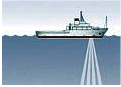
ADCP de coque des navires océanographiques français
Simple
- Date ( Création )
- 2014-01-01T00:00:00
- Identificateur
- FR-330-715-368-00032-IFR_ADCP
- Identificateur
- DOI:10.12770/60ad1de2-c3e1-4d33-9468-c7f28d200305
- Reconnaissance
- Ifremer, IRD
- Etat
- Mise à jour continue
+33 (0)2 98.22.46.44
http://www.ifremer.fr/sismer/
+33 (0)2 98.22.46.44
http://www.ifremer.fr/sismer/
- Fréquence de mise à jour
- Lorsque nécessaire
- Mots clés ( Localisation )
-
- couverture mondiale
- GEMET - INSPIRE themes, version 1.0 GEMET - INSPIRE themes, version 1.0 ( Thème )
-
- Caractéristiques géographiques océanographiques
- Thèmes Sextant Thèmes Sextant ( Thème )
-
- /Activités humaines/Campagnes océanographiques
- Mots clés ( Discipline )
-
- courantométrie
- Mesure de navire en route
- AtlantOS Element AtlantOS Element ( Thème )
-
- Réseaux
- Centre de données ODATIS Centre de données ODATIS ( Thème )
-
- CDS-IS-SISMER
- Variables ODATIS Variables ODATIS ( Thème )
-
- /Physique de l'Océan/Courant
- Type de jeux de donnée ODATIS Type de jeux de donnée ODATIS ( Thème )
-
- /Observations in-situ/Campagnes
- Thèmatiques ODATIS Thèmatiques ODATIS ( Thème )
-
- Campagnes en mer
- Thématiques - SIMM Thématiques - SIMM ( Thème )
-
- Recherche
- /Etat du Milieu/Hydrodynamique
- Sous-regions marines Sous-regions marines ( Localisation )
-
- National
- Contraintes d'accès
- Droit d’auteur / Droit moral (copyright)
- Limitation d'utilisation
- Aucune condition ne s’applique
- Type de représentation spatiale
- Vecteur
- Dénominateur de l'échelle
- 50000
- Langue
- fr
- Jeu de caractères
- Utf8
- Catégorie ISO
-
- Océans
))
- Nom du système de référence
- EPSG / WGS 84 (EPSG:4326) / 7.9
- Niveau topologie
- Géométrie seulement
- Format (encodage)
-
-
(
)
-
(
)
- Ressource en ligne
-
FTP ADCP
(
WWW:DOWNLOAD-1.0-link--download
)
FTP ADCP
- Ressource en ligne
-
CAMPAGNES_ADCP
(
OGC:WMS
)
ADCP Global
- Ressource en ligne
-
CAMPAGNES_ADCP
(
OGC:WFS
)
ADCP Global
- Ressource en ligne
-
DOI du jeu de donnée
(
WWW:LINK-1.0-http--metadata-URL
)
DOI du jeu de donnée
- Niveau
- Jeu de données
Résultat de conformité
- Date ( Création )
- 2012-01-16
- Explication
- Non évalué
- Degré de conformité
- Non
- Généralités sur la provenance
-
Les données ont été acquises par les navires océanographiques Ifremer, SHOM et IRD.
Les données sont contrôlées et validées par le SISMER suivant un protocole défini.
- Description
-
L'onde acoustique émise se réfléchit sur la matière en suspension et se déphase proportionnellement à la vitesse des réflecteurs (effet Doppler). Ces particules sont supposées se déplacer à la vitesse de la masse d'eau. Un courant est alors calculé dans la direction de chaque faisceau.
Grâce à la connaissance de l'orientation du capteur par rapport au navire, de l'orientation du navire par rapport à un repère terrestre et grâce à la connaissance de la vitesse du navire, un courant absolu peut être calculé.
- But du processus
- Acquisition de la donnée
- Description
-
Les données sont traitées avec le logiciel CASCADE (Chaine Automatisée de Suivi des Courantomètres Acoustiques Doppler Embarqués). CASCADE est un logiciel de validation et de visualisation des mesures d'ADCP de coque initié en 1998 au LPO (Laboratoire Physique des Océans - Ifremer) pour ses besoins de recherche dans le traitement et l'analyse des mesure d'ADCP et qui fait l'objet de mises à jour régulières.
Il a ensuite été mis en oeuvre dans un mode opérationnel par le centre de données SISMER.
Il est constitué d'un ensemble de programmes matlab.
- But du processus
- Traitement de la donnée
- Description
-
A l'issue du traitement des données d'ADCP avec le logiciel CASCADE, des données sont disponibles et téléchargeables au format Netcdf.
Pour une campagne, on trouvera :
1) Des fichiers Netcdf (ou plus, si différents modes d'acquisition ont été analysés avec CASCADE)
- 1 fichier de données brutes *_0_osite.nc : Il représente la concaténation des fichiers STA (ou LTA) issus de VMDAS. Les courants sont des courants absolus ou relatifs, exprimés dans le repère géographique et géo-référencés. Ils sont accompagnés de mesures annexes permettant d'évaluer ces données (amplitude de l'écho reçu, estimation de l'erreur, mesures d'attitude et de vitesse de navire, vitesse sur le fond, ...).
- 1 fichier de données validées *0E*.nc ou *1E*.nc intermédiaire entre les données brutes et le fichier final filtré comprenant les données validées affectées d'une information de qualité (flag) - ceci pour les années récentes
- 1 fichier de données validées *_fhv*.nc : Il représente les données validées, corrigées, affectées d'une information de qualité (flag).
2) 1 fichier compressé (au format UNIX.tar) de figures issues du logiciel CASCADE : Ce fichier contient des figures (au format .png) de vecteurs, de bathymétrie, de route, de tracés divers, ....
Ces figures sont également présentes dans le document compte-rendu par navire et par année lié aux données.
- But du processus
- Diffusion de la donnée
- Identifiant de la fiche
- 60ad1de2-c3e1-4d33-9468-c7f28d200305 XML
- Langue
- fr
- Jeu de caractères
- Utf8
- Type de ressource
- Collection de données
- Date des métadonnées
- 2022-05-16T15:41:07.928Z
- Nom du standard de métadonnées
- ISO 19115:2003/19139 - SEXTANT
- Version du standard de métadonnées
- 1.0
Centre IFREMER de Brest
BP 70
, PLOUZANE , 29280 , France+33 (0)2 98.22.46.44
http://www.ifremer.fr/sismer/
Aperçus
Étendue spatiale
Fourni par
