 Mon GéoSource
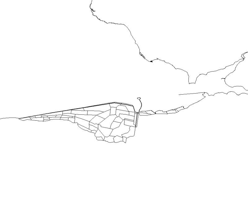
Polders de la baie du Mont Saint-Michel. État 1999.
Simple
- Autres appellations ou acronymes
- SIMON_polderEPHE99_P
- Autres appellations ou acronymes
- PNEC_POLDER_MSM_P
- Date ( Création )
- 2005-01-01T00:00:00
- Identificateur
- PNEC_POLDER_MSM_P
- Forme de la présentation
- Carte numérique
- Etat
- Finalisé
- Fréquence de mise à jour
- Non planifiée
- Thèmes Sextant Thèmes Sextant ( Thème )
-
- /Activités humaines/Activités agricoles
- Mots clés ( Thème )
-
- Polder
- Mots clés ( Localisation )
-
- Baie du Mont Saint-Michel
- Bretagne
- Basse-Normandie
- Ille-et-Vilaine
- GEMET - INSPIRE themes, version 1.0 GEMET - INSPIRE themes, version 1.0 ( Thème )
-
- Installations agricoles et aquacoles
- Limitation d'utilisation
- Utilisation interdite pour un usage commercial
- Contraintes d'utilisation
- Autres restrictions
- Autres contraintes
-
Citation sur les cartes obligatoire de la référence suivante : "Sources : SPOT © CNES (1999). Numérisation par X. LI (Laboratoire de Géomorphologie et Environnement littoral UMR 8586 PRODIG CNRS/EPHE).
Citation dans la bibliographie obligatoire de la mention suivante : X. Li, 2005. Contribution à la mise en place d'une base de données à référence spatiale en baie du Mont Saint-Michel. Mémoire de diplôme de l'École Pratique des Hautes Études. 85 p.
- Type de représentation spatiale
- Vecteur
- Dénominateur de l'échelle
- 25000
- Langue
- fr
- Jeu de caractères
- Utf8
- Catégorie ISO
-
- Agriculture
- Environnement
- Altitude
- Planification/Cadastre
- Océans
- Description
- Date de prise de vue de l'image SPOT
- Description
- Année de création de la figure source (J. Le Rhun, 1982. Étude physique de la baie du Mont Saint-Michel. Thèse de 3ème cycle de l'Université de Paris. 313 p.)
))
- Informations supplémentaires
-
Cette donnée a été numérisée sur l'image SPOT © CNES de la baie du Mont Saint-Michel (1999). Les données attributaires et les contours des polders ont été définis à partir d'une figure de J. le Rhun (J. Le Rhun, 1982. Étude physique de la baie du Mont Saint-Michel. Thèse de 3ème cycle de l'Université de Paris. 313 p.), elle-même réalisée à partir de témoignages et de la thèse de F. Verger (F. Verger, 1968. Marais et wadden du littoral français. Étude géomorphologique littorale. Thèse de Doctorat de l'université de Paris. 544 p.).
Cette numérisation a été réalisée par X. LI (LI X., 2005. Contribution à la mise en place d'une base de données à référence spatiale en baie du Mont Saint-Michel". Mémoire de diplôme de l'École Pratique des Hautes Études. 85 p.).
Détail des champs attributaires :
- DATE_DE_CR : année de la poldérisation de la parcelle.
- Nom du système de référence
- 4326
- Niveau topologie
- Géométrie seulement
- Type de géométries des objets
- Polygone
- Nombre d'objets géométriques
- 58
Distributeur
- Ressource en ligne
- PNEC_POLDER_MSM_P ( OGC:WMS )
- Niveau
- Jeu de données
- Généralités sur la provenance
- Cette donnée a été numérisée sur l'image SPOT © CNES de la baie du Mont Saint-Michel (1999). Une figure de J. Le Rhun (J. Le Rhun, 1982. Étude physique de la baie du Mont Saint-Michel. Thèse de 3ème cycle de l'Université de Paris. 313 p.) a par ailleurs servi d'aide au positionnement des parcelles et à l'alimentation des tables attributaires. Cette numérisation a été réalisée par X. LI (LI X., 2005. Contribution à la mise en place d'une base de données à référence spatiale en baie du Mont Saint-Michel". Mémoire de diplôme de l'École Pratique des Hautes Études. 85 p.). Les données ont été validées du point de vue attributaire et géométrique selon un protocole défini pour le SIG marin Baie du Mont Saint-Michel et à l'aide d'ArcGIS 9.2 (ESRI). Les opérations suivantes ont été effectuées : Supression du champ SOURCE et ID_CODE, vérification du type des champs, transformation des entités de multi-parties en une partie (avec ArcToolbox), vérification et correction de la topologie (ArcInfo) (superposition et de dicontinuité).
Information sur le contenu
- Identifiant de la fiche
- 62b34650-ad4f-11dc-9ee5-000086f6a62e XML
- Langue
- fr
- Jeu de caractères
- Utf8
- Type de ressource
- Jeu de données
- Date des métadonnées
- 2020-06-04T01:06:54
- Nom du standard de métadonnées
- ISO 19115:2003/19139 - SEXTANT
- Version du standard de métadonnées
- 1.0
Aperçus
Étendue spatiale
Fourni par
