 Mon GéoSource
Systematic conservation planning for the North-Atlantic deep sea
This dataset was built to feed a basin-wide spatial conservation planning exercise, targeting the deep sea of the North Atlantic, in the framework of the ATLAS H2020 project. This approach aimed to inform Marine Spatial Planning and conservation initiatives for the deep sea of the North Atlantic, by identifying conservation priority areas for the Vulnerable Marine Ecosystems (VMEs) and deep fish species and discussing the efficiency of the current spatial management context relatively to conservation stakes.
This publication provides (1) the links to spatial datasets used as an input, (2) the R scripts used to run the final conservation scenarios together with associated table of targets and connectivity matrix, that can be run on the input data, and (3) the outputs of the final scenarios constructed and computed for ATLAS.
Produced by IFREMER.
This output reflects the authors’ views and the European Union is not responsible for any use that may be made of the information it contains. Please note that you use these data at your own risk. No warranty is expressed or implied and no liability is accepted for any inconveniences or damages that may ensue from their use.
Simple
- Date ( Publication )
- 2019-09-10
- Identificateur
- FR-330-715-368-00032-IFR_MARBEC_ATLAS_Fishing_Catch
- Identificateur
- DOI:10.17882/62541
- Reconnaissance
- Horizon 2020 ATLAS project (EU)
- Thèmes Sextant ( Thème )
-
- /Human Activities/Industrial Fishing
- GEMET - INSPIRE themes, version 1.0 ( Thème )
-
- Habitats and biotopes
- Mots clés
-
- systematic conservation planning
- prioritization
- deep sea
- Atlantic
- Limitation d'utilisation
- CC-BY-NC-SA (Creative Commons - Attribution, Pas d’utilisation commerciale, Partage dans les mêmes conditions)
- Contraintes d'accès
- Licence
- Contraintes d'utilisation
- Licence
- Autres contraintes
- This output reflects the authors’ views and the European Union is not responsible for any use that may be made of the information it contains. Please note that you use these data at your own risk. No warranty is expressed or implied and no liability is accepted for any inconveniences or damages that may ensue from their use.
- Type de représentation spatiale
- Vecteur
- Langue
- en
- Jeu de caractères
- Utf8
- Catégorie ISO
-
- Océans
))
- Nom du système de référence
- +proj=aea +lat_1=43 +lat_2=62 +lat_0=30 +lon_0=-30 +x_0=0 +y_0=0 +datum=WGS84 +units=m +no_defs +ellps=WGS84 +towgs84=0,0,0
- Ressource en ligne
-
DOI of the dataset
(
WWW:LINK-1.0-http--metadata-URL
)
DOI of the dataset
- Ressource en ligne
-
IFR_MARBEC_ATLAS_CONNECTIVITY_OUTPUT_20DAYS
(
OGC:WMS
)
Spatial prioritization output : "connectivity with 20 days PLD" scenario
- Ressource en ligne
-
IFR_MARBEC_ATLAS_CONNECTIVITY_OUTPUT_20DAYS
(
OGC:WFS
)
Spatial prioritization output : "connectivity with 20 days PLD" scenario
- Ressource en ligne
-
IFR_MARBEC_ATLAS_BENTHIC_REGION_OUTPUT
(
OGC:WMS
)
Spatial prioritization output: "all benthic regionalised" scenario
- Ressource en ligne
-
IFR_MARBEC_ATLAS_BENTHIC_REGION_OUTPUT
(
OGC:WFS
)
Spatial prioritization output: "all benthic regionalised" scenario
- Ressource en ligne
-
IFR_MARBEC_ATLAS_FEATURE_OUTPUT
(
OGC:WMS
)
Spatial prioritization output: "all features" scenario
- Ressource en ligne
-
IFR_MARBEC_ATLAS_FEATURE_OUTPUT
(
OGC:WFS
)
Spatial prioritization output: "all features" scenario
- Ressource en ligne
-
IFR_MARBEC_ATLAS_MANAGEMENT_OUTPUT
(
OGC:WMS
)
Spatial prioritization output: "all management" scenario
- Ressource en ligne
-
IFR_MARBEC_ATLAS_MANAGEMENT_OUTPUT
(
OGC:WFS
)
Spatial prioritization output: "all management" scenario
- Ressource en ligne
-
IFR_MARBEC_ATLAS_SMALL_BASE_OUTPUT
(
OGC:WMS
)
Spatial prioritization output: "small base" scenario
- Ressource en ligne
-
IFR_MARBEC_ATLAS_SMALL_BASE_OUTPUT
(
OGC:WFS
)
Spatial prioritization output: "small base" scenario
- Niveau
- Jeu de données
Résultat de conformité
- Date ( Publication )
- 2010-12-08
- Explication
- See the referenced specification
- Généralités sur la provenance
-
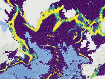
The output corresponding to five spatial management scenarios are published in shapefile format. To do so, each pixel of raster outputs (corresponding to a planning unit) was transformed to a polygon. The scenarios outputs are expressed as selection frequencies of planning units, reflecting how often the 25km * 25km units were selected within the n solutions of the scenario, from 0 for units that were never selected, to n for systematically selected units.
1- The base scenario ("all features")
2- The management scenario
3- The small base scenario
4- The connectivity scenario
5- The supplementary scenario “all benthic regionalised”
Reference of the ATLAS deliverable: Magali Combes, Sandrine Vaz, Telmo Morato, Laurence Fauconnet, Sophie Arnaud-Haond, Carlos Dominguez-Carrió, Alan Fox, José-Manuel González-Irusta, Marina Carreiro-Silva, Andrew Davies, Pablo Durán Muñoz, Hrönn Egilsdóttir, Lea-Anne Henry, Ellen Kenchington, Camille Lirette, F. Javier Murillo-Perez, Covadonga Orejas, Berta Ramiro-Sánchez, Luís Rodrigues, Steve W. Ross, Dick van Oevelen, Christopher K. Pham, Carlos Pinto, Neil Golding, Jeff A. Ardron, Francis Neat, Xuan Bui, Oisin Callery, Anthony Grehan, Pascal Laffargue, Murray Roberts, David Stirling, Gerald Taranto, Mathieu Woillez, Lénaick Menot. (2019) ATLAS D3.4 Conservation Management Issues in ATLAS. Basin-scale systematic conservation planning: identifying suitable networks for VMEs protection. https://www.eu-atlas.org/resources/atlas-library
Other complementary datasets and computation scripts may be found here:
Combes Magali, Vaz Sandrine (2019). Systematic conservation planning for the North-Atlantic deep sea. SEANOE. https://doi.org/10.17882/62541
This work has received funding from the European Union’s Horizon 2020 research and innovation program under grant agreements no. 678760 (ATLAS) and 679849 (SponGES).
- Description
-
The base scenario
The “base” scenario (also called “all features” scenario in Combes et al. 2019) targets VME-indicator benthic species (cold-water corals and sponge) as well as deep-water fish species, and habitat (VMEs, VME-supporting geomorphological structures) features, while replicating the conservation objectives in the different regions of the ocean basin, and considering an area-based cost. The conservation problem was solved 100 times and the 30 best solutions (wit h the lowest cost) were selected to evaluate the selection frequency of planning units.
- Description
-
The management scenario
The “management” scenario (also called “all management” scenario in Combes et al. 2019) targets VME-indicator benthic species (cold-water corals and sponge) as well as deep-water fish species, and habitat (VMEs, VME-supporting geomorphological structures) features, while replicating the conservation objectives in the different regions of the ocean basin, and integrating socio-economic and spatial management aspects as a varying cost and a spatial constraint. The location of areas with a legal protection or designation lowered planning units’ cost, the deep-sea fishing catch rates over the ocean increased planning units’ cost, and the location of deep-sea mining areas excluded certain planning units from solutions. A confidence index associated to the likelihood of units to host VMEs was also included in costs (lowering planning units’ cost). The conservation problem was solved 100 times and the 30 best solutions (with the lowest cost) were selected to evaluate the selection frequency of planning units.
- Description
-
The small base scenario
The small version of the “base” scenario (called “no connectivity” scenario in Combes et al. 2019) corresponds to the “base” scenario run on a smaller study area matching with the extent of connectivity modelling. This scenario was run to compare the “base” and “connectivity” scenarios on the same extent basis. The conservation problem was solved 100 times and the 30 best solutions (with the lowest cost) were selected to evaluate the selection frequency of planning units.
- Description
-
The connectivity scenario
Connectivity data was obtained from a Langrangian particle tracking model, implemented for hypothetical benthic larvae with a 20 days pelagic larval duration (PLD) and an 80 days PLD. Connectivity scenarios were implemented on a smaller study area than others, matching with the extent of the VIKING20 ocean circulation model used to produce connectivity data (30°N to 85°N and 81°W to 21°E in the Arctic and to 8°E in the Mediterranean). The “connectivity with 20 days PLD” scenario targets VME-indicator benthic species (cold-water corals and sponge) as well as deep-water fish species, and habitat (VMEs, VME-supporting geomorphological structures) features, while replicating the conservation objectives in the different regions of the ocean basin, favouring a connected conservation network based on the modelled dispersal of 20 days PLD benthic larvae, and considering an area-based cost. The conservation problem was solved 30 times and the 11 solutions that were achieved before the solving time limit were selected to evaluate the selection frequency of planning units.
- Description
-
The supplementary scenario “all benthic regionalised”
This “all benthic regionalised” scenario is one of the outputs from Combes et al. (2019). Its difference with the “base” scenario is the absence of fish species features. It targets the VME-indicator benthic species (cold-water corals and sponge), and habitat (VMEs, VME-supporting geomorphological structures) features, while replicating the conservation objectives in the different regions of the ocean basin, and considering an area-based cost. The conservation problem was solved 100 times and the 30 best solutions (with the lowest cost) were selected to evaluate the selection frequency of planning units.
- Source
-
- Deep-sea mining activities on the North Atlantic
- Deep-sea bathymetric variables (slope, depth, BPI) on the North Atlantic
- Geomophologic features (fractures, canyons, seamounts) on the North Atlantic
- debcbd09-4a36-48f3-a7c8-38f313eedd1b
- 3f14f4aa-ffaa-4152-865f-01be69048fce
- 786ae295-0922-4616-b5e0-db799f387fcc
- index of fishing catch from deep-sea impacting gears on the North Atlantic
- 113cd9cb-0a30-4297-b93d-5cf10124105b
- Identifiant de la fiche
- 72ec8ae8-e4d7-434a-b3f7-885f68a1a179 XML
- Langue
- en
- Jeu de caractères
- Utf8
- Type de ressource
- Jeu de données
- Date des métadonnées
- 2021-09-30T11:02:12
- Nom du standard de métadonnées
- ISO 19115:2003/19139 - SEXTANT
- Version du standard de métadonnées
- 1.0
Aperçus
Étendue spatiale
Fourni par
