 Mon GéoSource
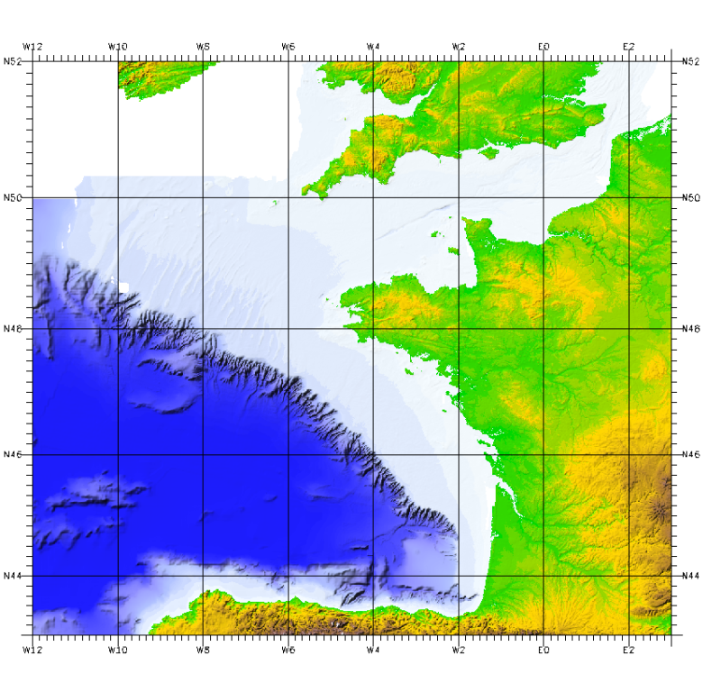
Bathy-morphologie régionale du Golfe de Gascogne et de la Manche (édition 2008, résolution 500 et 1000 m)
Ces modèles bathymétriques sont le résultat de la compilation de données et modèles numériques antérieurs à 2008 dans la zone du Golfe de Gascogne.
Ces jeux de données sont disponibles à 500 m et 1 000 m de résolution. Les isobathes sont aussi disponibles pour les deux modèle numérique de terrain (MNT) équidistantes de 50 m pour le MNT 500 m, et équidistantes de 100 m pour le MNT 1 000 m.
Accès tout public sous conditions.
Simple
- Autres appellations ou acronymes
- Synthese_MancheGascogne_1000m_BATHY
- Autres appellations ou acronymes
- Synthese_MancheGascogne_1000m_Isobathes100m
- Autres appellations ou acronymes
- Synthese_MancheGascogne_500m_BATHY
- Autres appellations ou acronymes
- Synthese_MancheGascogne_500m_Isobathes50m
- Date ( Publication )
- 2010-01-01T00:00:00
- Date ( Création )
- 2008-01-01T00:00:00
- Edition
- édition Ifremer-SHOM
- Date d'édition
- 2010-01-01T00:00:00
- Identificateur
- FR-330-715-368-00032-Synthese_MancheGascogne_1000m_BATHY
- Forme de la présentation
- Carte numérique
- Reconnaissance
- © Ifremer-SHOM, © British Crown and Sezone Solutions Limited, 2010
- Etat
- Mise à jour continue
- Fréquence de mise à jour
- Non planifiée
- Thèmes Sextant Thèmes Sextant ( Thème )
-
- /Milieu physique/Bathymétrie/MNT
- /Milieu physique/Bathymétrie/Isobathes
- GEMET - INSPIRE themes, version 1.0 GEMET - INSPIRE themes, version 1.0 ( Thème )
-
- Altitude
- external.theme.gemet external.theme.gemet ( Thème )
-
- Fond marin
- Morphologie sous-marine
- Mots clés ( Thème )
-
- Bathymétrie
- Modèle Numérique de Terrain
- Mots clés ( Localisation )
-
- Golfe de Gascogne
- Manche
- Atlantique
- Mots clés ( Discipline )
-
- Géophysique
- Sous-regions marines Sous-regions marines ( Localisation )
-
- /Métropole/Golfe de Gascogne
- /Métropole/Manche mer du Nord
- /Métropole/Mers Celtiques
- Thématiques - SIMM Thématiques - SIMM ( Thème )
-
- /Etat du Milieu/Bathymétrie
- Recherche
- Type de jeux de donnée ODATIS Type de jeux de donnée ODATIS ( Thème )
-
- /Données dérivées/Produits composites
- Limitation d'utilisation
- Utilisation interdite pour un usage commercial.
- Limitation d'utilisation
- Modification et diffusion interdite de la donnée sans l'accord du distributeur.
- Limitation d'utilisation
- Ne pas utiliser pour la navigation
- Contraintes d'accès
- Autres restrictions
- Contraintes d'utilisation
- Droit d’auteur / Droit moral (copyright)
- Contraintes d'utilisation
- Licence
- Autres contraintes
- Obligation de citation : © Ifremer-SHOM, 2010
- Autres contraintes
- Obligation de citation : © British Crown and Sezone Solutions Limited
- Autres contraintes
- Obligation de citation : LOUBRIEU B., BOURILLET J.F., MOUSSAT E., Bathy-morphologie régional du Golfe de Gascogne et de la Manche, modèle numérique 2008. Rapport interne Ifremer DCD/GM/CTDI/08-01
- Autres contraintes
- Ce produit a été dérivé en partie de matériaux obtenu à partir du Bureau hydrographique de Royaume-Uni avec la permission du contrôleur du HMSO et UK Hydrographic Office (www.ukho.gov.uk). NE PAS UTILISER POUR LA NAVIGATION. © British Crown and Sezone Solutions Limited. Tous droits réservés. Produits Licence n ° 112006.004."
- Autres contraintes
- Diffusion externe à l'Ifremer excluant les eaux Britanniques
- Type de représentation spatiale
- Raster
- Dénominateur de l'échelle
- 1000000
- Langue
- fr
- Jeu de caractères
- Utf8
- Catégorie ISO
-
- Altitude
))
- Date de début
- 1970-01-01T14:48:00
- Date de fin
- 2007-01-01T14:48:00
- Nom du système de référence
- EPSG / WGS 84 / World Mercator (EPSG:3395) / 7.4
- Dimensions
- 2
- Noms des axes
- Axe - Y
- Nombre de pixel
- 1033
- Résolution
- 1000 m
- Noms des axes
- Axe - X
- Nombre de pixel
- 1162
- Résolution
- 1000 m
- Type de raster
- Point
- Disponibilité des paramètres de transformation
- Non
Distributeur
- Ressource en ligne
-
Service Hydrographique et Océanographique de la Marine - SHOM
(
WWW:LINK
)
Service Hydrographique et Océanographique de la Marine - SHOM
- Ressource en ligne
- Ifremer - accès aux données ( WWW:LINK )
- Ressource en ligne
-
Synthese_MancheGascogne_1000m_BATHY
(
OGC:WMS
)
Bathymétrie résolution 1 000 m
- Ressource en ligne
-
Synthese_MancheGascogne_500m_BATHY
(
OGC:WMS
)
Bathymétrie résolution 500 m
- Ressource en ligne
-
Synthese_MancheGascogne_1000m_Isobathes100m
(
OGC:WMS
)
Isobathes résolution 1 000 m
- Ressource en ligne
-
Synthese_MancheGascogne_500m_Isobathes50m
(
OGC:WMS
)
Isobathes résolution 500 m
- Niveau
- Jeu de données
Etendue verticale
- Valeur minimale
- -5174
- Valeur maximale
- 2330
CS Vertical
Vertical datum
Résultat de conformité
- Date ( Publication )
- 2007-03-14
- Explication
- Non évalué
- Degré de conformité
- Non
- Généralités sur la provenance
-
Le modèle de terrain inclut six sources principales de données ou d'informations.
Source 1 : Données multifaisceaux Ifremer, dont principalement le résultat de la cartographie de la ZEE française dans le Golfe de Gascogne publiée en 2000 et dont les données proviennent de systèmes multifaisceaux Seabeam, EM12D, EM300 ainsi que des données de la base de données du SHOM ;
Source 2 : Extraction de la base de données du SHOM, sondes échantillonnées dans des cellules de 500 m² (contrat SHOM E97/2006) sur l'ensemble du plateau continental Manche/atlantique ;
Source 3 : Extraction de la base de données du Service hydrographique britannique pour la Manche (contrat Seazone Solutions Ltd - licence number 11206.004) ;
Source 4 : Cartes Berthois du Golfe de Gascogne (1974 et 1983) digitalisées (2000) avec un pas d'échantillonnage de 500 m ;
Source 5 : Version antérieure 2006 du MNT Golfe de Gascogne au pas de grille de 500 m ;
Source 6 : Modèle topographique SRTM 30 secondes.
Pour le MNT de résolution 500 mètres, seules les données adaptées à ce pas de grille ont été intégrées.
- Description
-
Le MNT 500 m résulte de la fusion de 3 MNT, fusion effectuée par moyennage dans les zones éventuelles de recouvrement. Les 3 MNT sont les suivants :
- MNT1 créé à partir des données source 1 par moyenne sur un pas de 500 m.
- MNT2 au pas de grille de 500 m (Zone Manche et plateau Gascogne Nord) créé par krigeage des données de source 2 et 3. Les données source 4 sont utilisées comme données complémentaires (contrat IFREMER/ERMS Juillet 2007).
- MNT3 (Plateau continental Sud Gascogne) : maillage des données de source 2.
Le MNT 1 000 m est construit de la façon suivante :
- MNT1 : Le MNT au pas de grille de 500 m est échantillonné au pas de grille de 1 km. Son extension géographique résulte des opérations suivantes :
- MNT2 : Echantillonnage du MNT version antérieure 2006 (source 5) pour les profondeurs entre 5500 m et 300 m.
- MNT3 : Extraction de la zone de la marge cantabrique de ce même MNT source 5 (sans limitation de profondeur).
Puis, agrégation des MNT2 et MNT3 à MNT1 pour obtention du produit Manche-Gascogne, résolution 1km.
- Identifiant de la fiche
- 7462a470-b290-11de-b102-000086f6a603 XML
- Langue
- fr
- Jeu de caractères
- Utf8
- Type de ressource
- Jeu de données
- Date des métadonnées
- 2021-06-04T10:59:57
- Nom du standard de métadonnées
- ISO 19115:2003/19139 - SEXTANT
- Version du standard de métadonnées
- 1.0
Aperçus
Étendue spatiale
Fourni par
