 Mon GéoSource
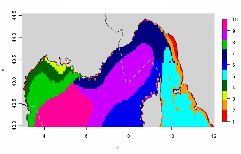
Distribution des paysages hydrologiques présentant une variabilité annuelle similaire identifiée en Méditerranée occidentale
La distribution des paysages hydrologiques est déterminée par une méthode de comparaison multi-tableaux afin d’identifier des groupes d’individus présentant une variabilité des conditions hydrologiques similaire au cours de l’année.
Les données utilisées permettent de disposer de tables mensuelles présentant les cinq paramètres physiques sélectionnés (SS, Phi, SST, MES et CHLA), calculés sur toute la zone géographique, à une résolution commune de 0,05°.
Cette méthode permet d’identifier 10 paysages hydrologiques présentant une variabilité annuelle similaire des conditions hydrologiques.
Simple
- Date ( Création )
- 2011-07-01
- Identificateur
- IFR_Paysages_hydro_Méd_Occ
- Reconnaissance
- Ifremer
- Thèmes Sextant Thèmes Sextant ( Thème )
-
- /Milieu biologique/Habitats
- GEMET - INSPIRE themes, version 1.0 GEMET - INSPIRE themes, version 1.0 ( Thème )
-
- Caractéristiques géographiques océanographiques
- Mots clés ( Thème )
-
- paysages hydrologiques; habitats pélagiques
- Sous-regions marines Sous-regions marines ( Localisation )
-
- /Métropole/Méditerranée occidentale
- Contraintes d'accès
- Droit de propriété intellectuelle / Droit patrimonial
- Contraintes d'utilisation
- Droit de propriété intellectuelle / Droit patrimonial
- Restrictions de manipulation
- Non classifié
- Type de représentation spatiale
- Raster
- Distance de résolution
- 0.05 degrès
- Langue
- fr
- Jeu de caractères
- Utf8
- Catégorie ISO
-
- Informations géoscientifiques
- Océans
))
- Informations supplémentaires
-
Cela distingue dans un premier temps les habitats côtiers, de faible profondeur et mélangés tout au long de l'année sous l'influence de la marée (groupes 1, 8) et/ou influencés par les fleuves (3), des habitats montrant une stratification saisonnière. Cette stratification thermique saisonnière est décalée dans le temps, et plus ou moins intense, du sud vers le nord (9, 7, 5, 6, 2). Le groupe 4 se distingue le long du talus au nord, présentant une moindre stratification saisonnière du fait du mélange par les ondes internes.
Grp 1
Biotope très côtier, très peu représenté dans la sous-région DCSMM, principalement présent le long de la côte italienne en face de Libourne. Habitat très peu profond, caractérisé par une faible dessalure uniquement au printemps, les températures de surface les plus importantes et des valeurs fortement élevées de chlorophylle a et MES.
Grp 2
Biotope très côtier proche du groupe 1, et également très peu présent dans la sous-région DCSMM. Cet habitat présente des caractéristiques similaires au groupe 1 avec une dessalure au printemps moins marquée et des valeurs importantes en MES en hiver, mais moins élevées que dans le premier groupe.
Grp 3
Biotope du panache du Rhône dans le golfe du Lion, avec des dessalures importantes au printemps mais surtout en automne, des MES élevées tout l'hiver, et des concentrations en chlorophylle élevées en moyenne, avec un pic en mai. Malgré la présence d’un panache et d’une stratification haline, la stratification de la colonne d’eau dans cette zone est
facilement rompue sous l'influence du Mistral.
Grp 4
Biotope du plateau du golfe du Lion, zone de dilution du panache, présentant des
dessalures relatives, peu stratifié et également moins riche en MES et chlorophylle que le panache (groupe 3) lui-même.
Grp 5
Biotope au large de la côte est de la Corse, donc peu représenté à l'intérieur de la sous-région DCSMM. Habitat très stratifié et fortement oligotrophe.
Grp 6
Biotope du large à l'ouest de la Corse. Proche du groupe 5, il est également très fortement stratifié, jusque tard dans la saison, et oligotrophe malgré la présence d'un léger bloom au printemps.
Grp 7
Biotope sous influence du courant Nord, issu de la convergence des groupes 5 et 6. Ce groupe est présent le long de la Côte d'Azur pour ce qui concerne la sous-région marine DCSMM, il est relativement chaud et peu productif en phytoplancton et se distingue des groupes 5 et 6 par une stratification saisonnière moins marquée.
Grp 8
Proche du groupe 7, ce biotope au large du golfe du Lion présente de faibles dessalures (sous l’influence conjuguée des eaux d’origine atlantique et des eaux du panache du golfe du Lion) et des températures de surface plus élevées en hiver et plus froides en été que le groupe 7.
Grp 9
Ce biotope, avec le groupe 10, constitue la zone centrale de convection hivernale, tous les deux caractérisés par une stratification relativement forte en été et un bloom élevé au printemps. Le biotope 9, moins soumis au forçage des vents pendant l’été, présente des températures légèrement plus élevées et une stratification plus forte l'été que le groupe
voisin 10.
Grp 10
Ce groupe très proche du groupe 9 se distingue par des températures moins élevées et une stratification légèrement plus faible l'été, sous l’influence du Mistral et de la Tramontane.
- Nom du système de référence
- EPSG / WGS84 géographiques / 7.4
- Format (encodage)
-
-
Esri shapes
(
ArcGIS 9.3.1
)
-
Esri shapes
(
ArcGIS 9.3.1
)
- Ressource en ligne
- site internet Ifremer dédié à la Directive Cadre Stratégie pour le Milieu Marin ( WWW:LINK )
- Ressource en ligne
-
carthothèque DCSMM
(
WWW:LINK
)
Distribution des biotopes principaux de la colonne d'eau (pélagiques)
- Niveau
- Jeu de données
- Généralités sur la provenance
-
Méthodologie d'identification des paysages hydrologiques:
Les indices hydrodynamiques, développés dans des études antérieures, sélectionnés ici sont les suivants :
- Salinité de surface (SS) : indice « panaches fluviaux ».
- Température de surface (SST, °C).
- Indices de stratification de la colonne d’eau : déficit d’énergie potentielle qui représente l’énergie nécessaire pour homogénéiser (en température, en salinité ou en densité) la colonne d’eau avec la masse volumique moyenne sur la colonne d’eau, la masse volumique à la profondeur z, la profondeur maximum (fixée ici à 100m), et la hauteur de la surface libre (Huret M., Struski C, Léger F, Petitgas P., Lazure P. and Sourisseau M. 2009. Modélisation couplée physique-biogéochimie du golfe de Gascogne sur la période 1971-2007. R.INT.DOP/EMH/ 2009-01.)
La turbidité peut également jouer un rôle sur la distribution spatiale des populations pélagiques. En référence aux espèces ichtyologiques, il peut être judicieux d'élargir la notion de biotope en prenant en compte le plancton, constituant l'alimentation de certaines populations ichtyologiques, et donc structurant leur distribution. C’est pourquoi l’ajout du paramètre Chlorophylle-a a été envisagée dans cette étude, en l'absence de données suffisamment synoptiques pour le zooplancton.
Sources de données:
Afin de décrire les propriétés physiques influant sur la répartition spatiale des populations, des mesures in situ de salinité et de température sur toute la colonne d’eau sont utilisées.
En Méditerranée, la climatologie MEDAR/MEDATLAS (2004) rassemble l’ensemble des mesures in situ collectées lors des campagnes océanographiques depuis plus d’un siècle. Des estimations par interpolation verticale permettent d’obtenir des moyennes mensuelles sur toute la colonne d’eau (à intervalles irréguliers). La résolution spatiale pour l’ensemble de la Méditerranée est de 0,2° mais une résolution plus fine, de 0,05°, est disponible sur une zone plus restreinte autour du Golfe du Lion, utilisée pour l’analyse. Cette zone ne couvre pas la totalité de la sous-région marine Méditerranée occidentale de la DCSMM, mais offre des résultats plus pertinents.
Concernant les trois autres paramètres, des estimations des moyennes mensuelles (de 2003 à 2010) de la température de surface et des concentrations en matières en suspension inorganiques et en chlorophylle a dans la couche de surface sont disponibles grâce aux images satellitales. La résolution spatiale de ces données est de 0,044° en longitude et en latitude (cf. contribution thématique « chlorophylle ») [10]. Les données de type climatologiques mensuelles utilisées ici ne permettent pas de capturer la variabilité spatio-temporelle associée aux structures hydrodynamiques à méso-échelle, qui caractérisent l’hydrodynamique de la Méditerranée. Ces structures transitoires, telles que les tourbillons, les zones de front et les upwellings, peuvent pourtant expliquer la distribution spatio-temporelle de certaines populations.
En outre, d’autres indices proposés dans les études antérieures, complémentaires au déficit d’énergie potentielle et décrivant de manière intégrée les caractéristiques de la colonne d’eau, n’ont pas été intégrés dans cette analyse (profondeur de la couche de mélange et gradient vertical maximum de température). Ces indices se sont révélés pertinents pour l’identification de paysages hydrologiques dans les autres sous régions marines de la DCSMM, mais calculés à partir des données MEDATLAS, ils n’ont pas permis d’identifier des structures hydrologiques pertinentes au regard des connaissances de l’hydrodynamique de cette région. En revanche, la température de surface, qui a été mise de côté pour l'analyse conjointe sur la Manche, les Mers Celtiques et le golfe de Gascogne, ceci afin d'éviter la trop forte stratification latitudinale qu'elle induirait sur la classification des habitats, a été prise en compte sur la zone Méditerranée bien plus limitée spatialement. De même la chlorophylle a, qui ne répond pas à l’objectif de cette étude d’identification de « paysages physiques » a participé, au même titre que les autres indices physiques, à l’analyse. L’ajout de ces deux variables a en effet permis de discriminer certaines structures hydrologiques jouant un rôle important dans l’hydrodynamique et la répartition des populations pélagiques dans cette région.
- Identifiant de la fiche
- ae844353-958d-4fc8-a756-f5ce8d079105 XML
- Langue
- fr
- Jeu de caractères
- Utf8
- Type de ressource
- Collection de données
- Nom du niveau de hiérarchie
- Ensemble de jeux de données
- Date des métadonnées
- 2020-06-04T00:51:01
- Nom du standard de métadonnées
- ISO 19115:2003/19139 - SEXTANT
- Version du standard de métadonnées
- 1.0
Aperçus
Étendue spatiale
Fourni par
