 Mon GéoSource
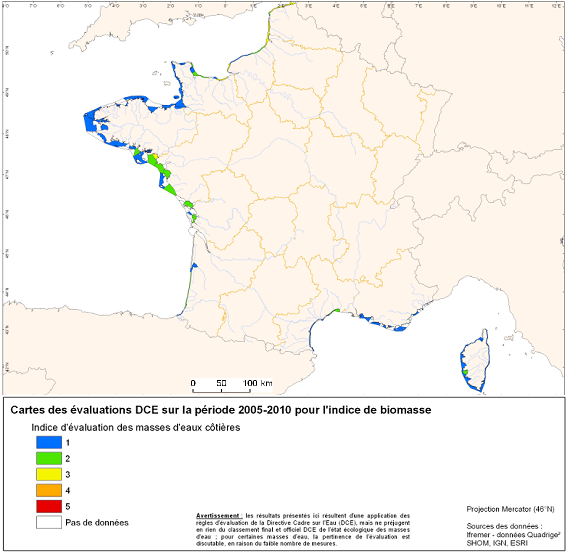
Indices d'évaluations DCE des masses d'eaux cotières métropolitaine sur la période 2005-2010
Dans le cadre de la Directive Cadre sur l’Eau (2000/60/CE), parmi les paramètres biologiques participant à l’évaluation des masses d’eau côtières, l’élément de qualité « phytoplancton » est défini. Cet indicateur phytoplancton est constitué de plusieurs indices dont l’indice de biomasse et l’indice d’abondance.
Le bilan d’oxygène figure parmi les éléments de qualité physico-chimiques retenus pour la classification de l’état écologique des masses d’eaux littorales.
L’élément de qualité « invertébrés benthiques » fait également parti des paramètres biologiques participant à l’évaluation de ces masses d’eau.
Simple
- Date ( Révision )
- 2009-07-09T00:00:00
- Identificateur
- CW
- Forme de la présentation
- Carte numérique
- But
- Les masses d'eau côtière ont été élaborée par les travaux de l'IFREMER et les Agences de l'eau pour les besoins de la directive cadre sur les eaux. Les spécifications ont été élaborés par le groupe Référentiels du SIE.
- Reconnaissance
- Ifremer, Agences de l'eau, DCE
- Etat
- Finalisé
02 23 18 58 50
02 40 37 42 41
02 98 22 45 48
- Fréquence de mise à jour
- Non planifiée
- Thèmes Sextant Thèmes Sextant ( Thème )
-
- /Activités humaines/Activités scientifiques
- Mots clés ( Thème )
-
- Indicateur biologique
- Indicateur physico-chimique
- DIRECTIVE CADRE EAU
- DCE
- MASSE D'EAU COTIERE
- Mots clés ( Localisation )
-
- FRANCE
- GEMET - INSPIRE themes, version 1.0 GEMET - INSPIRE themes, version 1.0 ( Thème )
-
- Caractéristiques géographiques océanographiques
- Sous-regions marines Sous-regions marines ( Localisation )
-
- /Métropole
- Contraintes d'accès
- Droit d’auteur / Droit moral (copyright)
- Contraintes d'utilisation
- Droit d’auteur / Droit moral (copyright)
- Autres contraintes
- none
- Type de représentation spatiale
- Vecteur
- Dénominateur de l'échelle
- 50000
- Langue
- fr
- Jeu de caractères
- Utf8
- Catégorie ISO
-
- Océans
- Date de début
- 2005-01-01T16:12:00
- Date de fin
- 2010-01-01T16:12:00
))
- Informations supplémentaires
-
L’indicateur biomasse est le percentile 90 des valeurs de concentration en chlorophylle a mesurée mensuellement entre mars et octobre (Soudant et al., 2010). L’indice d’abondance est basé sur la fréquence des blooms. Un bloom est défini sur les côtes françaises de la Manche / mer du Nord comme une concentration supérieure à 100 000 ou 250 000 cellules par litre2, pour un taxon donné dans un échantillon (Soudant et al., 2010). La fréquence mesurée des blooms est ensuite comparée à la fréquence jugée naturelle pour la région, égale ici à deux mois de blooms sur les douze mois d’une année (un bloom au printemps et un autre en automne).
Les résultats des évaluations pour ces deux indices sont réalisés à partir des données Quadrige² sur la période 2005-2010 pour les masses d’eau côtières.
Le bilan d’oxygène figure parmi les éléments de qualité physico-chimiques retenus pour la classification de l’état écologique. La métrique retenue est le percentile 10. Elle se calcule sur des données mensuelles, acquises en été (de juin à septembre) et pendant six ans, au fond et en sub-surface de la colonne d’eau. Les méthodes de prélèvement et d’analyses sont détaillées dans les rapports Daniel (2007) et Aminot et Kerouel (2004). Comme la concentration en oxygène dissous est le seul paramètre utilisé, cet indice est également l'indicateur pour l'élément de qualité. La valeur de référence (= valeur de très bon état) pour le bilan d’oxygène est 8.33 mg/l. Les données sont extraites de la base Quadrige2 en date du 2 mai 2011.
Les macroinvertébrés benthiques constituent d'excellents intégrateurs et indicateurs de l'état général du milieu et peuvent permettre notamment, grâce à certains organismes sensibles, d'identifier et de quantifier les pressions d'origine anthropique qui s'exercent sur ces masses d'eau. Ils peuvent être ainsi de bons témoins de l’enrichissement du milieu en matières organiques. Les métriques de cet élément de qualité, permettant de définir l'état écologique, sont le niveau de diversité et d'abondance des taxa et l’ensemble des taxa sensibles aux perturbations.
L’indicateur retenu pour la qualification des masses d’eau côtières est le M-AMBI (Desroy et al., 2009 et Desroy et al., 2010). Il repose sur :
- l’indicateur AMBI lui-même basé sur la reconnaissance dans le peuplement de cinq groupes écologiques de polluosensibilités différentes, comme proposé par Hily (1984).
Cet indice est basé sur la pondération de chaque groupe écologique par une constante qui représente le niveau de perturbation auquel les espèces sont associées.
- la richesse spécifique, ou nombre d’espèces présentant au moins un individu pour la station
- l’indice de diversité de Shannon-Weaver
- Nom du système de référence
- EPSG / 4326 - WGS84 géographique / 7.4
- Format (encodage)
-
-
ESRI shapefile
(
ArcGIS 9.3.1
)
-
ESRI shapefile
(
ArcGIS 9.3.1
)
- Ressource en ligne
- site internet Ifremer dédié à la Directive Cadre Stratégie pour le Milieu Marin ( WWW:LINK )
- Ressource en ligne
-
DCSMM_INDICE_MASSES_EAU_ABOND
(
OGC:WMS
)
Abondance phytoplancton
- Ressource en ligne
-
DCSMM_INDICE_MASSES_EAU_BIO
(
OGC:WMS
)
Biomasse phytoplancton
- Ressource en ligne
-
DCSMM_INDICE_MASSES_EAU_INVERT
(
OGC:WMS
)
Invertébrés benthiques
- Ressource en ligne
-
DCSMM_INDICE_MASSES_EAU_OXY
(
OGC:WMS
)
Oxygène
- Niveau
- Jeu de données
- Généralités sur la provenance
- Les masses d'eau côtière ont pour interface terre/mer le traît de côte du SHOM au 1:25000
- Description
- Version 1.1 / Intégration des modification de l'AESN
- Période du processus
- 2005-02-18T00:00:00
- Description
- Version 1.2 / Intégration des modifications de l'agence RMC
- Période du processus
- 2005-04-19T00:00:00
- Description
- Version 1.3 / Intégration des DOM (Guadeloupe, Martinique, Réunion)
- Période du processus
- 2005-04-29T00:00:00
- Description
- Intégation données rapportage 2009
- Période du processus
- 2009-07-09T00:00:00
- Identifiant de la fiche
- c9857bb9-277a-4c83-9615-8a8972089393 XML
- Langue
- fr
- Jeu de caractères
- Utf8
- Type de ressource
- Jeu de données
- Date des métadonnées
- 2020-06-04T00:37:28
- Nom du standard de métadonnées
- ISO 19115:2003/19139 - SEXTANT
- Version du standard de métadonnées
- 1.0
Aperçus
Étendue spatiale
Fourni par
