 Mon GéoSource
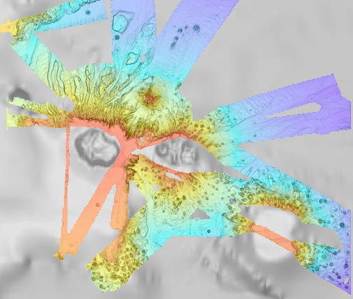
Bathymétrie - Archipel de Crozet (synthèse, 2022), résolution 100 mètres
Bathymétrie de l'archipel de Crozet, au pas de 100 mètres. Ce Modèle Numérique de Terrain est une compilation de données bathymétriques issues de différentes sources.
Référence verticale : niveau moyen observé des mers.
Rapport de traitement : Loubrieu Benoit, Pierre Delphine, Biville Romain, Le Duff Mathilde (2013). Digital Terrain Model for the HA04 hydroacoustic station, Crozet Islands, France. CB/GM/CTDI-BL2013-01
Les données sont issues des campagnes :
- SCHLICH Roland (1998) KERIMIS-MD109 cruise, RV Marion Dufresne, https://doi.org/10.17600/98200010
- HUMLER Eric (2001) MD 121 / SWIFT cruise, RV Marion Dufresne, https://doi.org/10.17600/1200030
- METZL Nicolas, PIERRE Catherine (2001) VT 51 / OISO 6 cruise, RV Marion Dufresne, https://doi.org/10.17600/1200010
- ASLANIAN Daniel, HUMLER Eric, MICHEL Elisabeth (2002) MD 125 / SWIFT BIS-CARHOT cruise, RV Marion Dufresne, https://doi.org/10.17600/2200020
- MICHEL Elisabeth (2004) MD 136 / VIGO cruise, RV Marion Dufresne, https://doi.org/10.17600/4200110
- ROEST Walter (2005) MD 150 /DELCANO RISE-KERGUEPLAC2 cruise, RV Marion Dufresne, https://doi.org/10.17600/5200060
- VIALLY Roland, BRUNET Christian, ROYER Jean-Yves (2008) MD 165 / KERGUEPLAC 3 cruise, RV Marion Dufresne, https://doi.org/10.17600/8200010
- ROEST Walter, JOHNSON Sean (2010) MD176 Discovery Ridge-CrozetPlac cruise, RV Marion Dufresne, https://doi.org/10.17600/18001444
- CROSTA Xavier (2019) MD 218 / CROTALE cruise, RV Marion Dufresne, https://doi.org/10.17600/18000886
+ transits du R/V Marion Dufresne MD202 (2016) et MD207 (2017)
Simple
- Date ( Publication )
- 2022-08-05
- Date ( Création )
- 2013-03-01
- Date ( Révision )
- 2022-07-22
- Identificateur
- FR-330715-368-00032-Synthese_Crozet_100m_BATHY
- Reconnaissance
- Ifremer
- Thèmes Sextant Thèmes Sextant ( Thème )
-
- /Milieu physique/Bathymétrie
- GEMET - INSPIRE themes, version 1.0 GEMET - INSPIRE themes, version 1.0 ( Thème )
-
- Altitude
- GEMET - Concepts, version 2.4 GEMET - Concepts, version 2.4 ( Thème )
-
- fond marin
- morphologie sous-marine
- Mots clés ( Discipline )
-
- Bathymétrie
- Limitation d'utilisation
- CC BY. Licence Creative Commons Attribution 4.0 International https://creativecommons.org/licenses/by/4.0/
- Contraintes d'accès
- Autres restrictions
- Contraintes d'utilisation
- Licence
- Autres contraintes
- Pas de restriction d'accès public
- Limitation d'utilisation
- Ne pas utiliser pour la navigation
- Type de représentation spatiale
- Raster
- Distance de résolution
- 100 meter
- Langue
- fr
- Jeu de caractères
- Utf8
- Catégorie ISO
-
- Océans
))
- Date de début
- 1998-02-21
- Date de fin
- 2019-03-11
Information sur la représentation spatiale
- Dimensions
- 2
- Noms des axes
- Axe - X
- Nombre de pixel
- 1551
- Noms des axes
- Axe - Y
- Nombre de pixel
- 1332
- Type de raster
- Surface
- Format (encodage)
-
-
GeoTIFF
(
1.0
)
-
GeoTIFF
(
1.0
)
- Ressource en ligne
- Synthese_Crozet_100m_BATHY ( OGC:WMS )
- Protocole
- COPYFILE
- Nom
- Synthese_Crozet_100m_BATHY
- Ressource en ligne
- Rapport de traitement ( WWW:LINK )
- Ressource en ligne
- Digital Object Identifier (DOI) ( WWW:LINK-1.0-http--metadata-URL )
- Niveau
- Jeu de données
Résultat de conformité
- Date ( Publication )
- 2010-12-08
- Explication
- See the referenced specification
- Généralités sur la provenance
- Ce MNT résulte d'une synthèse des données de sondeur multifaisceaux, disponible dans la région de l'Archipel de Crozet.
- Identifiant de la fiche
- daed529e-eba2-4286-8cd9-677516c3ccdb XML
- Langue
- fr
- Jeu de caractères
- Utf8
- Type de ressource
- Jeu de données
- Date des métadonnées
- 2022-08-09T12:38:11.977Z
- Nom du standard de métadonnées
- ISO 19115:2003/19139 - SEXTANT
- Version du standard de métadonnées
- 1.0
Aperçus
Étendue spatiale
Fourni par
