 Mon GéoSource
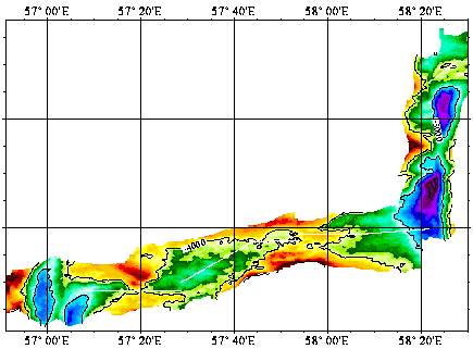
Dorsale sud-ouest indienne entre les failles transformantes Atlantis II et Novara - 120m
Simple
- Date ( Création )
- 2000-01-26
- Identificateur
- IFR_MBAN_DORSALES_INDIEN_SWIR_AII_BATHY_120_R
- Identificateur
- DOI:10.12770/db3d6aea-a434-45af-b58f-2f4fea3d3c3a
- Reconnaissance
- Le projet s'inscrit dans le cadre du programme national Dorsales et représente la contribution française au projet Banques de données du programme InterRidge (cf. InterRidge News 1997,vol. 6/1 et 1999, vol. 8/1).
+33 (0)2 98.22.46.44
http://www.ifremer.fr/sismer/
- Thèmes Sextant Thèmes Sextant ( Thème )
-
- /Milieu physique/Bathymétrie/MNT
- GEMET - INSPIRE themes, version 1.0 GEMET - INSPIRE themes, version 1.0 ( Thème )
-
- Altitude
- Thématiques - SIMM Thématiques - SIMM ( Thème )
-
- /Etat du Milieu/Géologie
- /Etat du Milieu/Bathymétrie
- Type de jeux de donnée ODATIS Type de jeux de donnée ODATIS ( Thème )
-
- /Données dérivées/Produits composites
- Sous-regions marines Sous-regions marines ( Localisation )
-
- /Outre-mer/Océan Indien
- Thématiques - SIMM Thématiques - SIMM ( Thème )
-
- Recherche
- Limitation d'utilisation
- CC-BY (Creative Commons - Attribution)
- Contraintes d'accès
- Autres restrictions
- Contraintes d'utilisation
- Licence
- Autres contraintes
- Mendel V., Sauter D., Parson L., and Vanney J.R., 1997. Segmentation and morphotectonic variations along an ultra-slow spreading centre: the Southwest Indian Ridge (57˚E - 70˚E). Mar. Geophys. Res., 19, p. 505-553
- Type de représentation spatiale
- Raster
- Dénominateur de l'échelle
- 25000
- Langue
- fr
- Jeu de caractères
- Utf8
- Catégorie ISO
-
- Altitude
))
- Nom du système de référence
- EPSG / WGS 84 (EPSG:4326) / 8.6
- Dimensions
- 2
- Noms des axes
- Axe - X
- Résolution
- 0.0013 degres
- Noms des axes
- Axe - Y
- Résolution
- 0.001099 degres
- Type de raster
- Surface
- Format (encodage)
-
-
(
)
-
(
)
- Ressource en ligne
-
IFR_MBAN_DORSALES_INDIEN_SWIR_AII_BATHY_120_R
(
OGC:WMS
)
Bathymétrie à 120m de résolution
- Protocole
- FILE
- Nom
- IFR_MBAN_DORSALES_INDIEN_SWIR_AII_BATHY_120_R
- Description
- Bathymétrie 120m - format .tif
- Ressource en ligne
-
DOI du jeu de données
(
WWW:LINK-1.0-http--metadata-URL
)
DOI du jeu de données
- Protocole
- COPYFILE
- Nom
- IFR_MBAN_DORSALES_INDIEN_SWIR_AII_BATHY_120_R_GRD
- Description
- Bathymétrie 120m - format .grd
- Ressource en ligne
- DOI de la campagne - CAPSING ( WWW:LINK )
- Niveau
- Jeu de données
- Généralités sur la provenance
-
Source(s) des données : SIMRAD EM12 Dual pendant la campagne Capsing du N/O L’Atalante en 1993
Contrôle(s) qualité effectués : Les points aberrants des bandes SIMRAD ont été éliminés si la différence entre leur valeur et la moyenne du cycle de mesures est supérieure à 3 fois l’écart type calculé sur ce cycle (critére de Chauvenet. In : Tuttle, L. and J. Satterly, 1925. The theory of measurements, Longmans, Green and Co., UK). Les points aberrants qui subsistent après ce traitement (profondeur fausses ou recourbement "curl up" des faisceaux externes) ont été éliminés de manière interactive en visualisant les données à l’écran.
Méthode de calcul du paramètre représenté : interpolation au plus proche voisin
Logiciel de maillage utilisé : logiciel Cetis de l’IPG Strasbourg (Boulanger, M.O., Boulanger, D., Munschy, M., Sauter, D & Tissot, J.D., 1992 - CETIS : a new computer software to display marine geophysical data, improve navigation using Seabeam crossings, grid data and process images. XVII ème EGS, Edinburgh, avril 1992.)
- Description
- Pour les petits trous de 10 pixels, une simple interpolation linéaire a été utilisée. Pour les trous plus larges, nous avons utilisé une interpolation qui tient compte de la direction des structures bathymétriques de part et d’autre des trous (Sauter et al., 1996), ceci pour éviter d’avoir des isobathes aux courbes non réalistes. (Sauter D., Whitechurch H., Nafziger J.M., & Munschy M., 1996 - Segmentation and morphotectonic variations of the Central Indian Ridge between 21˚10'S and 22˚25'S. J. Geophys Res., 101, p. 20233-20256)
- But du processus
- Interpolation
- Description
- Un lissage par recherche de la médiane locale dans une matrice carrée 3x3 a été appliqué aux grilles bathymétriques. Ce lissage, équivalent d’un filtre passe-bas, effectue un classement par valeur croissante des pixels voisins du pixel courant et affecte à ce dernier la valeur médiane des pixels classés. L’avantage d’un tel lissage est d’éliminer les pics ponctuels sans dégrader la qualité de l’image initiale.
- But du processus
- Lissage
Information sur le contenu
- Identifiant de la fiche
- db3d6aea-a434-45af-b58f-2f4fea3d3c3a XML
- Langue
- fr
- Jeu de caractères
- Utf8
- Type de ressource
- Jeu de données
- Date des métadonnées
- 2020-08-31T11:25:22
- Nom du standard de métadonnées
- ISO 19115:2003/19139 - SEXTANT
- Version du standard de métadonnées
- 1.0
Aperçus
Étendue spatiale
Fourni par
