 Mon GéoSource
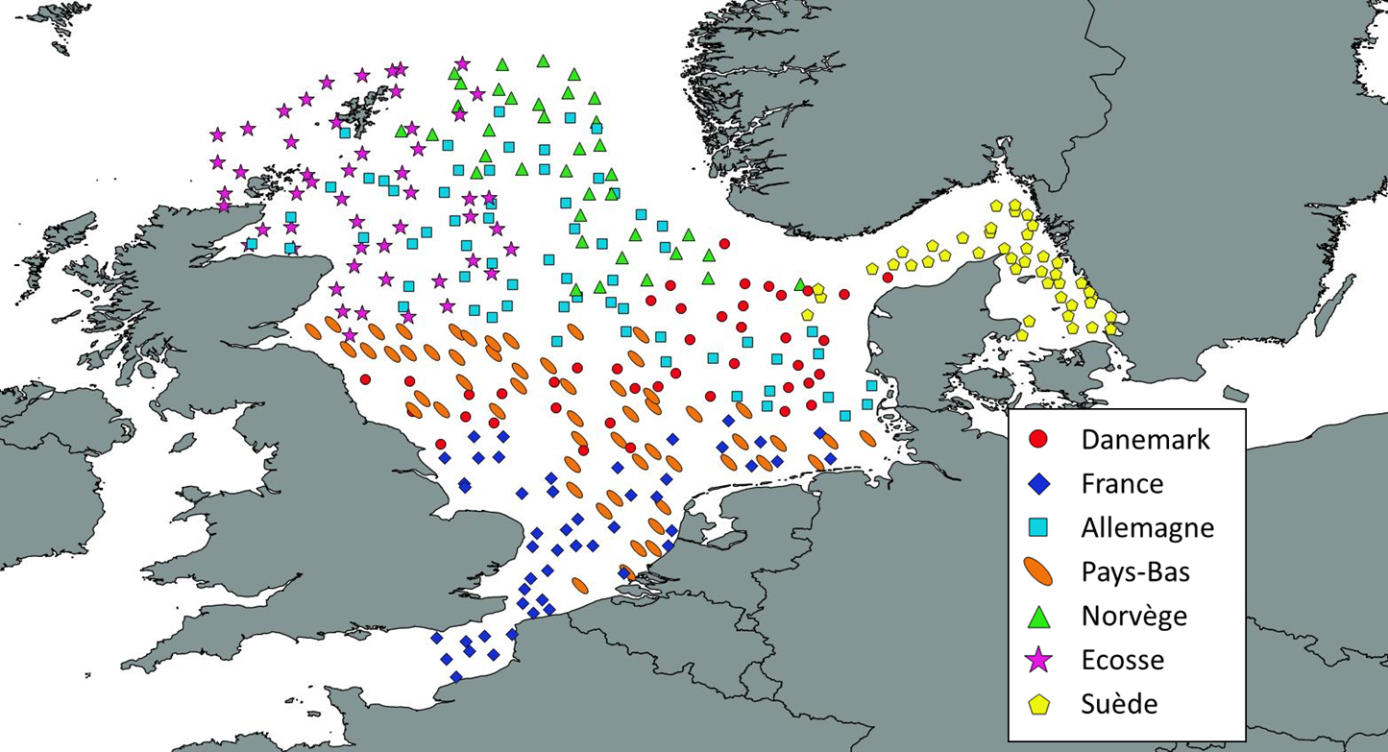
Campagne océanographique - IBTS (International Bottom Trawl Survey) - Manche Mer du Nord
Simple
- Date ( Publication )
- 2022-02-08
- Identificateur
- FR-DCSMM-PDS-IBTS
- Forme de la présentation
- Profil numérique
- Reconnaissance
- IFREMER
- Etat
- Mise à jour continue
- Fréquence de mise à jour
- Annuelle
- Mots clés ( Thème )
-
- Suivi halieutique
- Chalutages GOV
- Zooplancton, Invertébrés benthique, Poissons
- Oiseaux marins, Mammifères marins
- Déchets marins
- Manche orientale
- Mer du Nord
- Evaluation des stocks de poissons
- Etat de santé de l'écosystème
- GEMET - INSPIRE themes, version 1.0 GEMET - INSPIRE themes, version 1.0 ( Thème )
-
- Installations de suivi environnemental
- Sous-regions marines Sous-regions marines ( Localisation )
-
- /Métropole/Manche mer du Nord
- DCSMM : Type d'espace concerné DCSMM : Type d'espace concerné ( Thème )
-
- Pas d'espace particulier concerné
- DCSMM : Descripteurs DCSMM : Descripteurs ( Thème )
-
- D3: Espèces commerciales
- D10: Déchets marins
- D1: Biodiversité - Oiseaux
- D1: Biodiversité - Mammifères
- DCSMM : Méthodes de recueil des données DCSMM : Méthodes de recueil des données ( Thème )
-
- Observation indirecte
- Piégeage, capture
- Thèmes Sextant Thèmes Sextant ( Thème )
-
- /Activités humaines/Campagnes océanographiques
- SIH - Types de jeu de données SIH - Types de jeu de données ( Thème )
-
- /Données observées/Campagnes
- SIH - Façade maritime SIH - Façade maritime ( Thème )
-
- Manche - Mer du Nord
- Cadre Réglementaire - SIMM Cadre Réglementaire - SIMM ( Thème )
-
- Directive Cadre Stratégie pour le Milieu Marin (DCSMM)
- Thématiques - SIMM Thématiques - SIMM ( Thème )
-
- /Activités et Usages/Pêche et Aquaculture
- Type de jeux de donnée ODATIS Type de jeux de donnée ODATIS ( Thème )
-
- /Observations in-situ/Campagnes
- Contraintes d'accès
- Restreint
- Langue
- fr
- Jeu de caractères
- Utf8
- Catégorie ISO
-
- Océans
- Date de début
- 1986-01-11
))
- Informations supplémentaires
-
Financeurs :
IFREMER
Europe
Direction des Pêches Maritimes et de l'Aquaculture (DPMA)
- Format (encodage)
-
-
(
)
-
(
)
- Ressource en ligne
- Manuel pour les campagnes internationales au chalut de fond ( WWW:LINK )
- Ressource en ligne
- Indices de populations et de communautés IBTS ( WWW:LINK )
- Ressource en ligne
- Catalogue des campagnes : IBTS
- Ressource en ligne
-
campagnes_IBTS
(
OGC:WMS
)
Campagnes IBTS (WMS)
- Ressource en ligne
- Accès aux données des campagnes halieutiques du SIH ( WWW:LINK )
- Niveau
- Jeu de données
Résultat de conformité
- Date ( Création )
- 2012-01-16
- Explication
- Non évalué
- Degré de conformité
- Non
- Généralités sur la provenance
-
Les principaux objectifs sont :
- constitution de séries temporelles d'indices d'abondances pour les principales espèces commerciales de la mer du Nord (évaluation des principaux stocks de poissons commerciaux de Mer du Nord : merlan, morue, églefin, tacaud norvégien, hareng, sprat, maquereau, plie).
- calcul de l'indice larvaire pour le hareng et le sprat.
Les objectifs complémentaires sont :
- échantillonnage des œufs au CUFES (Continuous Underwater Fish Eggs Sampling) en Mer du Nord.
- étude de la distribution et de l'abondance relative hivernale des mammifères et oiseaux marins en Mer du Nord.
-enregistrement des données acoustiques (pour analyse ultérieure).
Le projet de rattachement est "International Bottom Trawl Survey - Evaluations des pêcheries sous gestion communautaires, et sous gestion non communautaires. Système d'Informations Halieutiques".
01-01-1960 : Les premières campagnes pour le suivi des juvéniles de hareng sont mises en place sont mises en place par les Pays-Bas et l'Allemagne. Ces campagnes IYHS (International Young Herring Survey) sont coordonnées par l'ICES (International Council for the Exploitation of the Sea).
01-01-1962 : Progressivement, les autres pays riverains s'associent à ce programme et la zone d'étude est étendue à l'ensemble de la mer du Nord. D'autres espèces sont intégrées au suivi et les campagnes sont renommées IYFS (International Bottom Trawl Survey).
01-01-1976 : La France s'associe à ce programme et couvre au premier trimestre de chaque année deux zones importantes pour la pêcherie Française, l'une au sud de la mer du Nord et l'autre en Ouest Ecosse.
01-01-1980 : Un groupe de travail chargé de coordonner les campagnes en mer du Nord et d'analyser les données et créé. C'est le début officiel de cette série de campagne de suivi.
01-01-1992 : Pour assurer une meilleure coordination de l'ensemble des campagnes mises en place par les pays à différentes périodes de l'année, aussi bien en mer du Nord que dans l' Atlantique nord-ouest, il a été décidé de créer un groupe de travail commun chargé d'analyser les données.
01-01-1996 : Les résultats de cet échantillonnage bi-annuel en mer du Nord sont analysé et l'ICES conclue de continuer les deux campagnes annuelles en redistribuant l'effort des pays participants qui conserve une campagne soit au premier trimestre comme la France, soit au second trimestre comme la France.
01-01-1997 : A partir de cette année, la campagne française a lieu une fois par an au cours de la période hivernale. Elle est chargée d'échantillonner le sud de la mer du Nord.
01-01-2007 : La zone d'échantillonnage allouée à la France et aux Pays-Bas est étendue à la manche Orientale.
01-01-2015 : Remplacement du Navire ‘Gwen Drez’ par le navire ‘Thalassa II’.
01-01-2017 : Réduction du nombre de jours en mer (23 jours contre 30 auparavant)
Pour la Collecte de données sur les déchets : analyse des données par catégories , cartographie et tendance selon un protocole harmonisé au niveau européen.
- Protocole validé depuis 1994 (MEDITS) et 1995 (IBTS/EVHOE)
- Protocole harmonisé au niveau européen (maille, protocole, chaluts)
- Protocole retenu pour la mise ne place de la DCSMM au niveau européen
Limites : dispositif devant être complété localement pour les petits fonds ( 0-20 mètres).
• Plan(s) d’échantillonnage :
Aléatoire, stratifié
• Précision sur le type de donnée :
- Pour la faune :
Melanogrammus aeglefinus ; Merlangius merlangus ; Gadus morhua ; Trisopterus esmarki ; Clupea harengus ; sprattus sprattus ; scomber scombrus ; Pleuronectes platessa
Oiseaux marins
Zooplancton ; invertébrés benthique ; poissons
Mammifères marins
- Pour les déchets :
Inventaire des différents types de déchets (plastiques, verre, métal, bouteilles plastiques, cuir et tissus, engins de pêche, divers)
• Paramètre(s) observé(s) ou mesuré(s) :
- Pour la faune :
Dénombrement des juvéniles. Prélèvement d'otolithe
Observation à bord du navire
Présence dans l'échantillon de zooplancton depuis 2008 ; présence et détermination des poissons invertébrés benthiques
- Pour les déchets :
Densité
• Résolution du (ou des) paramètre(s) :
- Pour la faune :
Par opération de pêche, analyse systématique des captures de pêche scientifiques
- Pour les déchets :
Densité par hectare
• Format(s) :
Les données disponibles existent sous le format : csv
- Identifiant de la fiche
- db467716-0d8a-4626-ab07-654de3df06ec XML
- Langue
- fr
- Jeu de caractères
- Utf8
- Identifiant de la fiche de métadonnées parent
- Oceanographic cruises - Observations for fisheries monitoring 99e16a35-8090-4897-aa2b-c5c0951aabea
- Type de ressource
- Collection de données
- Date des métadonnées
- 2022-02-15T15:27:41.332Z
- Nom du standard de métadonnées
- ISO 19115:2003/19139 - SEXTANT
- Version du standard de métadonnées
- 1.0
Aperçus
Étendue spatiale
Fourni par
