 Mon GéoSource
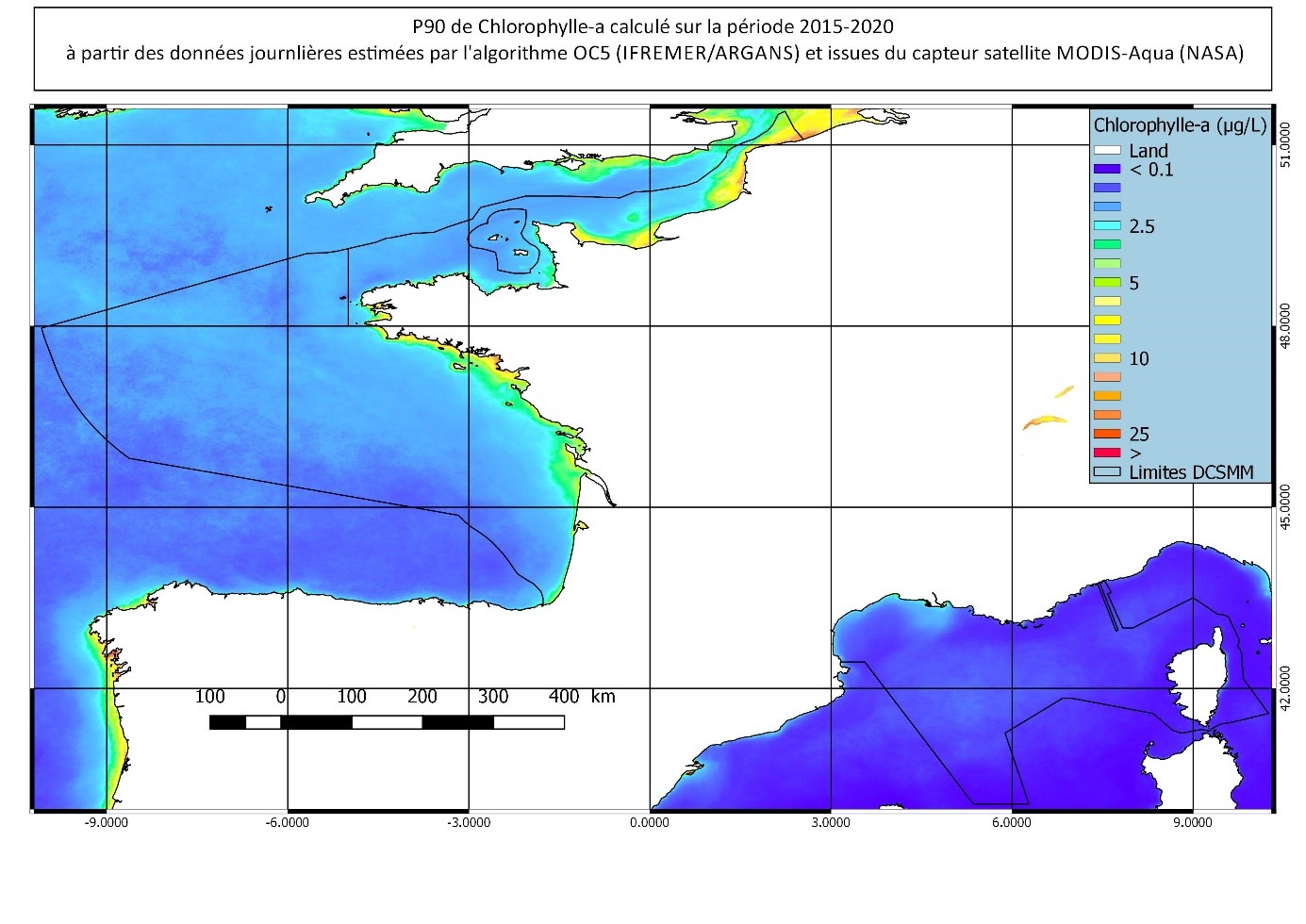
Percentile 90 de la Chlorophylle (MODIS) 2015-2020
Percentile 90 calculé sur la période productive au sens DCE (mars-octobre) 2015-2020, à partir des Chl-a MODIS traitées par l'algorithme OC5 IFREMER/ARGANS (Gohin et al 2002, Gohin 2011).
Simple
- Autres appellations ou acronymes
- P90
- Date ( Publication )
- 2021-06-29T17:05:00
- Identificateur
- p90_modis_chlorophyll_a_2015-2020_3to10_dcsmm
- Forme de la présentation
- Carte numérique
- Autres informations de référence
- MODIS/NASA capteur AQUA
- Reconnaissance
- NASA, Argans
- Etat
- Finalisé
Editeur (publication)
Ifremer
-
SISMER
02 98 22 45 48
Centre Bretagne - ZI de la Pointe du Diable - CS 10070 - 29280 Plouzané
,
Brest
,
France
02 98 22 43 15
02 98 22 45 48
- Fréquence de mise à jour
- Lorsque nécessaire
- Thèmes Sextant Thèmes Sextant ( Thème )
-
- /Imagerie/Imagerie satellitale
- GEMET - INSPIRE themes, version 1.0 GEMET - INSPIRE themes, version 1.0 ( Thème )
-
- Caractéristiques géographiques océanographiques
- external.theme.gemet external.theme.gemet ( Thème )
-
- chlorophylle
- Mots clés ( Thème )
-
- chlorophylle-a
- Satellite
- Type de jeux de donnée ODATIS Type de jeux de donnée ODATIS ( Thème )
-
- /Télédétection
- Thématiques - SIMM Thématiques - SIMM ( Thème )
-
- /Etat du Milieu/Biogéochimie
- Sous-regions marines Sous-regions marines ( Localisation )
-
- /Métropole
- Cadre Réglementaire - SIMM Cadre Réglementaire - SIMM ( Thème )
-
- Directive Cadre Stratégie pour le Milieu Marin (DCSMM)
- DCSMM : Descripteurs DCSMM : Descripteurs ( Thème )
-
- D1: Biodiversité - Habitats pélagiques
- D1: Biodiversité - Céphalopodes
- D1: Biodiversité - Poissons
- D5: Eutrophisation
- D6: Intégrité des fonds marins
- D7: Changements hydrographiques
- Limitation d'utilisation
- CC-BY-NC-ND (Creative Commons - Attribution, Pas d’utilisation commerciale, Pas de modification)
- Contraintes d'accès
- Autres restrictions
- Contraintes d'utilisation
- Droit de propriété intellectuelle / Droit patrimonial
- Autres contraintes
- Ces données ne peuvent être utilisées que dans le cadre de la DCSMM et pour des projets de recherche mais en aucun cas pour dans un cadre commercial.
- Type de représentation spatiale
- Raster
- Distance de résolution
- 1200 m
- Langue
- fr
- Langue
- en
- Jeu de caractères
- Utf8
- Catégorie ISO
-
- Océans
- Description de l'environnement de travail
- Microsoft Windows XP ; ESRI ArcGIS 9.x
- Identifiant géographique
- Plateau Ouest-Européen
- Date de début
- 2015-01-01T00:00:00
- Date de fin
- 2020-12-31T23:55:00
N
S
E
W
))
- Informations supplémentaires
- Gohin, F., Druon, J. N., and Lampert, L.: A five channel chlorophyll concentration algorithm applied to SeaWiFS data processed by Seadas in coastal waters, International Journal of Remote Sensing, 23, 1639-1661, 10.1080/01431160110071879, 2002.
- Nom du système de référence
- WGS 84 (EPSG:4326)
- Dimensions
- 2
- Noms des axes
- Axe - X
- Nombre de pixel
- 1367
- Résolution
- 0.015 degree
- Noms des axes
- Axe - Y
- Nombre de pixel
- 1160
- Résolution
- 0.01 degree
- Type de raster
- Surface
- Disponibilité des paramètres de transformation
- Non
- Protocole
- WWW:DOWNLOAD-1.0-link--download
- Nom
- p90_modis_chlorophyll_a_2015-2020_3to10_dcsmm
- Description
- Percentile90 - Chlorophylle-A (Geotiff)
- Protocole
- WWW:DOWNLOAD-1.0-link--download
- Nom
- mean_modis_chlorophyll_a_2015-2020_3to10_dcsmm
- Description
- Moyenne - Chlorophylle-A (Geotiff)
- Protocole
- WWW:DOWNLOAD-1.0-link--download
- Nom
- stdev_modis_chlorophyll_a_2015-2020_3to10_dcsmm
- Description
- Ecart-type - Chlorophylle-A (Geotiff)
- Protocole
- WWW:DOWNLOAD-1.0-link--download
- Nom
- nbpts_modis_chlorophyll_a_2015-2020_3to10_dcsmm
- Description
- Nombre de pixels utilisés en chaque point - Chlorophylle-A (Geotiff)
- Niveau
- Jeu de données
Résultat de conformité
- Date ( Publication )
- 2007-03-14
- Explication
- Non évalué
- Degré de conformité
- Non
- Généralités sur la provenance
-
Capteur : satellite MODIS-Aqua (NASA)
Période : 2015-2020
Algorithmes : OC5 IFREMER/ARGANS (Gohin et al 2002, Gohin 2011).
Produit élaboré : P90 calculé sur la période 2015-2020 à partir des données journalières + Moyenne, écart type et nombre de pixels utilisés pour le calcul en chaque point de la carte.
- Identifiant de la fiche
- e0946900-961f-42af-baa9-d6524d66d3b2 XML
- Langue
- fr
- Jeu de caractères
- Utf8
- Type de ressource
- Jeu de données
- Date des métadonnées
- 2022-04-15T10:13:08.27Z
- Nom du standard de métadonnées
- ISO 19115:2003/19139 - SEXTANT
- Version du standard de métadonnées
- 1.0
Aperçus
Étendue spatiale
N
S
E
W
Fourni par

Ressources associées
Not available