 Mon GéoSource
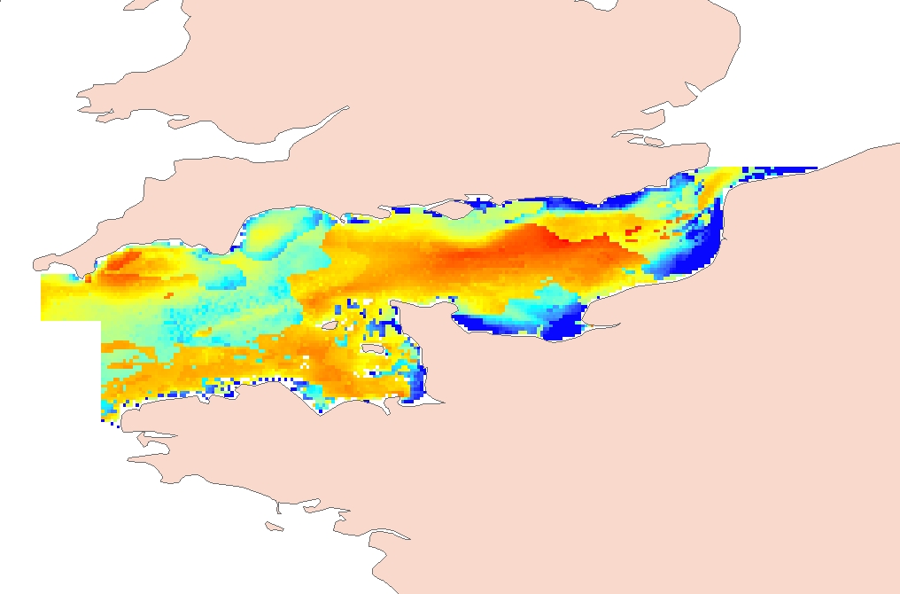
English Channel process-driven seafloor habitat sensitivity
Process-driven seafloor habitat sensitivity (PDS) has been defined from the method developed by Kostylev and Hannah (2007), which takes into account physical disturbances and food availability as structuring factors for benthic communities. It is a conceptual model, relating species’ life history traits to environmental properties. Physical environment maps have been converted into a map of benthic habitat types, each supporting species communities with specific sensitivity to human pressures. It is based on two axes of selected environmental forces.
The "Disturbance" (Dist) axis reflects the magnitude of change (destruction) of habitats (i.e. the stability through time of habitats), only due to natural processes influencing the seabed and which are responsible for the selection of life history traits. The "Scope for Growth" (SfG) axis takes into account environmental stresses inducing a physiological cost to organisms and limiting their growth and reproduction potential. This axis estimates the remaining energy available for growth and reproduction of a species (the energy spent on adapting itself to the environment being already taken into account). It can be related to the metabolic theory of the ecology.
The process-driven sensitivity (PDS) can be seen as a risk map that combines the two previous axes and reflects the main ecological characteristics of the benthic habitats regarding natural processes. Areas with low disturbance are areas with a naturally low reworking of the sediment, allowing the establishment of a rich sessile epifauna community, with K-strategy species. Areas with low SfG means that the environmental factors, even though there are not limiting, are in lower values, i.e. that it imposes a cost for species to live. In areas combining low disturbance and low SfG, big suspension-feeder species with long life and slow growth can often be found: these species are more vulnerable in case of added disturbance.
Details may be found in Foveau A, Vaz S, Desroy N, Kostylev VE (2017) Process-driven and biological characterisation and mapping of seabed habitats sensitive to trawling. PLoS ONE 12(10): e0184486. https://doi.org/10.1371/journal.pone.0184486
Simple
- Date ( Publication )
- 2016-09-20T00:00:00
- Identificateur
- FR-330-715-368-00032-IFR_ENG_CHANNEL_SENSITIVE_SEABED_HABITATS
- Reconnaissance
- IFREMER
02 23 18 58 50
- Thèmes Sextant ( Thème )
-
- /Biological Environment/Habitats
- Mots clés ( Discipline )
-
- benthic sensitivity
- Limitation d'utilisation
- Données sous Licence ouverte / Open licence : http://www.etalab.gouv.fr/pages/licence-ouverte-open-licence-5899923.html
- Contraintes d'accès
- Droit d’auteur / Droit moral (copyright)
- Contraintes d'utilisation
- Autres restrictions
- Type de représentation spatiale
- Vecteur
- Langue
- en
- Jeu de caractères
- Utf8
- Catégorie ISO
-
- Environnement
))
- Date de début
- 1998-01-01T00:00:00
- Date de fin
- 2014-12-31T00:00:00
- Nom du système de référence
- EPSG / WGS 84 (EPSG:4326) / 8.6
- Type de géométries des objets
- Composite
- Format (encodage)
-
-
(
)
-
(
)
- Ressource en ligne
-
CHANNEL_SENSITIVE_SEABED_HABITATS_SFG
(
OGC:WMS
)
Scope for Growth
- Protocole
- COPYFILE
- Nom
- CHANNEL_SENSITIVE_SEABED_HABITATS_SFG
- Description
- Scope for Growth
- Ressource en ligne
-
CHANNEL_SENSITIVE_SEABED_HABITATS_RISK
(
OGC:WMS
)
Risk
- Protocole
- COPYFILE
- Nom
- CHANNEL_SENSITIVE_SEABED_HABITATS_RISK
- Description
- Risk
- Ressource en ligne
-
CHANNEL_SENSITIVE_SEABED_HABITATS_DISTURBANCE
(
OGC:WMS
)
Disturbance
- Protocole
- COPYFILE
- Nom
- CHANNEL_SENSITIVE_SEABED_HABITATS_DISTURBANCE
- Description
- Disturbance
- Ressource en ligne
-
DOI du jeu de données
(
WWW:LINK-1.0-http--metadata-URL
)
DOI du jeu de données
- Niveau
- Jeu de données
- Généralités sur la provenance
-
The intensity of friction was computed by combining:
- depth: data issued from the CHARM project, i.e. that depth is presented as bathymetry (derived from SHOM navigation charts, transformed in raster of 1 km spatial resolution) plus mean sea level (issued from MARD 3D hydrodynamic model, also transformed in raster of 1 km spatial resolution);
- waves: data coming from NORGAS model and compiled from year 2007 to 2009. The model has a resolution of 2’, i.e. 3.5 km. Temporal resolution is 3 hours. Significant period and height used are issued from the 90th percentile;
- tidal currents: data coming from 3D MANGA model (Previmer, Ifremer) and compiled from year 2004 to 2007. The spatial resolution is about 4 km and the temporal resolution is one hour. Data were used to compute first the daily average, then the 90th percentile of the bottom currents over the available period.
- Since hydrodynamic forces bring few changes to the sedimentary cover, a sediment mean grain size map was obtained by linking the mean grain size values observed from sedimentary samples to each of the five sediment categories from a simplified but large geographical extent sedimentary map.
Scope for Growth factors involved are:
- food availability: calculated from satellite data of chlorophyll a from 1998 to 2006, monthly mean, with a 1.2 km spatial resolution. Data were corrected with the relation of Legendre and Michaud (log [POC] = 2,27 + 0,35 log[Chla], applicable for depth lower than 300 m) to obtain values in Particular Organic Carbon, considered as food for benthic organisms ;
- monthly mean temperature and variation range (inter- and intra-annual variations), done on data from 2000 to 2006. Data come from NOAA satellite data of the sea surface temperature, with a spatial resolution of 1.2 km;
- mean salinity (calculated from issues of ECOMARS-3D model for year 2000 to 2006, monthly, with a spatial resolution of 4 km and a temporal resolution of six hours ;
- Description
- The critical shear stress was computed as a function of the grain size (X, mm) and derived from the Hjulström diagram empirically approximated by the equation: Y= -0.0272 × X^4- 0.0905 ×X^3+ 0.2411 × X^2+ 0.4691×X+1.8761 The disturbance was then defined as the ratio between the intensity of friction (or characteristic friction velocity) and the minimal critical current needed to initiate sedimentary movement (critical shear stress).
- Description
-
Before compiling the different environmental layers to define the SfG axis, data were reclassified between 0 and 1. Since reclassification is sensible to the geographical extent of the studied area, all layers were limited to the same extent.
The equation to calculate scope for growth is defined as:
SfG= (Fa+SST+S-Ta-Ti)
with Fa, food availability
SST, sea surface temperature
S, salinity
Ta, standard deviation between months of a year (done for each year and averaged over period)
Ti, standard deviation between years
- Description
-
The process-driven sensitivity (PDS) can be seen as a risk map that combines the two previous axes, according the formula :
risk =sqrt[(1-SfG)²+(1-Dist)²]
- Identifiant de la fiche
- eba76470-7dd5-4984-bfa8-c9df6a69276b XML
- Langue
- en
- Jeu de caractères
- Utf8
- Type de ressource
- Jeu de données
- Date des métadonnées
- 2018-01-18T13:11:31
- Nom du standard de métadonnées
- ISO 19115:2003/19139 - SEXTANT
- Version du standard de métadonnées
- 1.0
Aperçus
Étendue spatiale
Fourni par
