 Mon GéoSource
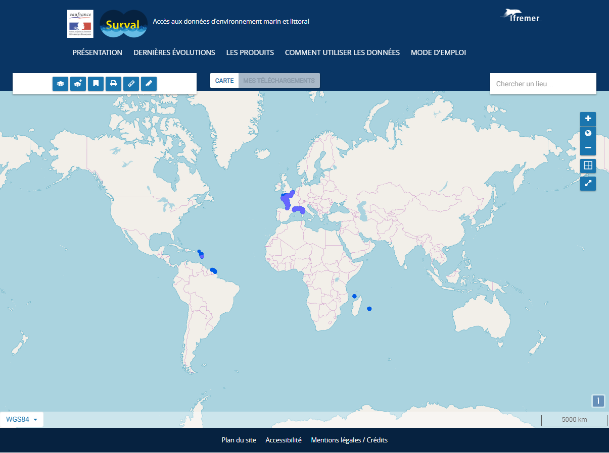
Lieux d'observation et de surveillance du réseau ROCCH
Le produit Surval "Inventaire des lieux actifs ROCCH" présente l’inventaire des lieux programmés actuellement pour un suivi. Ils donnent donc accès à la programmation des réseaux (un lieu dont la période d’activité dans Quadrige inclue la date du jour est considéré actif pour le programme). Pour accéder aux données d'observation, il faut passer par les lieux du produit Surval 'Données par paramètre".
Depuis 2008, le Réseau d'Observation de la Contamination CHimique du littoral (ROCCH) a pris la suite du RNO (Réseau National d'Observation de la qualité du milieu marin) qui existait depuis 1974. LE ROCCH a pour objectif de répondre aux obligations nationales, communautaires et internationales de surveillance chimique. Il est donc plus un réseau de contrôle qu'un réseau patrimonial tel que l'était le RNO.
La colonne vertébrale du ROCCH est l'application de la Directive Cadre européenne sur l'Eau (DCE) et la réponse aux obligations des Conventions OSPAR et de Barcelone. La décentralisation étant inscrite dans la DCE, le ROCCH est passé d'un maître d'ouvrage unique (le Ministère chargé de l'environnement) à de multiples donneurs d'ordres (agences de l'eau, DIREN, etc.). Les analyses chimiques ne sont plus confiées à l'Ifremer mais attribuées sur appels d'offres des maîtres d'ouvrage.
Le ROCCH intègre également le suivi chimique des zones de production conchylicoles pour le compte de la Direction Générale de l'Alimentation (DGAL) du Ministère de l'agriculture et de la pêche. Cette surveillance porte sur les trois métaux réglementés, mercure, plomb, cadmium dans les espèces exploitées. La surveillance des contaminants chimiques est effectuée dans les trois matrices marines, eau, biote et sédiment. A ce suivi il faut ajouter celui de l'imposex, effet biologique du tributylétain (TBT), obligation de la Convention OSPAR.
Le ROCCH inclut également le projet méditerranéen RINBIO qui consiste en un suivi des contaminants dans des moules implantées (cagging).
Simple
- Date ( Création )
- 2012-01-01T00:00:00
- Identificateur
- eddc7b90-5b1b-499f-83a9-411a887c5b17
- But
- Localiser des lieux actifs et historiques de suivi dans le cadre du ROCCH (ROCCH Organismes marins, RNO Hydrologie).
- Reconnaissance
- Ifremer
- Etat
- Mise à jour continue
- Fréquence de mise à jour
- Journalière
- Remarque sur la mise à jour
- Jeu de données ayant des mises à jour continues
- Thèmes Sextant Thèmes Sextant ( Thème )
-
- /Activités humaines/Réseaux d'observation et de surveillance du littoral
- Mots clés ( Thème )
-
- Lieux de surveillance
- ROCCH
- surveillance sanitaire
- Point de suivi
- Contamination
- Chimie
- Coquillage
- DCE
- OSPAR
- Observation
- Données ouvertes
- Open Data
- Quadrige
- Surval
- DCSMM
- Environnement
- Surveillance
- Environnement
- GEMET - INSPIRE themes, version 1.0 GEMET - INSPIRE themes, version 1.0 ( Thème )
-
- Installations de suivi environnemental
- DCSMM : Descripteurs DCSMM : Descripteurs ( Thème )
-
- D8: Contaminants
- D9: Questions sanitaires
- DCSMM : Méthodes de recueil des données DCSMM : Méthodes de recueil des données ( Thème )
-
- Observation par point
- Observation directe
- Sous-regions marines Sous-regions marines ( Localisation )
-
- /National
- Centre de données ODATIS Centre de données ODATIS ( Thème )
-
- CDS-IS-SISMER
- Variables ODATIS Variables ODATIS ( Thème )
-
- /Biogéochimie marine/Eléments chimiques et contaminants
- Type de jeux de donnée ODATIS Type de jeux de donnée ODATIS ( Thème )
-
- /Observations in-situ/Réseaux
- Thèmatiques ODATIS Thèmatiques ODATIS ( Thème )
-
- Dispositifs de surveillance
- Thématiques - SIMM Thématiques - SIMM ( Thème )
-
- /Etat du Milieu/Pollutions
- /Etat du Milieu/Biogéochimie
- Limitation d'utilisation
- Données sous Licence ouverte / Open licence : http://www.etalab.gouv.fr/pages/licence-ouverte-open-licence-5899923.html
- Contraintes d'accès
- Autres restrictions
- Contraintes d'utilisation
- Autres restrictions
- Autres contraintes
-
La Licence ouverte d'Etalab s'applique aux données Quadrige validées sans moratoire.
Conformément à cette licence le « Réutilisateur » est libre de réutiliser l’« Information » sous réserve de mentionner la paternité de l’« Information » : la source et la date de dernière mise à jour de l’« Information » réutilisée.
- Type de représentation spatiale
- Vecteur
- Dénominateur de l'échelle
- 5000
- Langue
- fr
- Jeu de caractères
- Utf8
- Catégorie ISO
-
- Océans
))
- Date de début
- 1975-01-01
- Informations supplémentaires
-
Maîtres d'ouvrage :
Agence de l'eau Adour-Garonne 2008
Agence de l'eau Artois-Picardie 2008
Agence de l'Eau Loire-Bretagne 2008
Agence de l'eau Rhône-Méditerranée et Corse 2008
Agence de l'eau Seine-Normandie 2008
Office de l'Eau de la Martinique 2008
maître d'oeuvre :
IFREMER 1974
Financeurs :
Agence de l'eau Adour-Garonne 2008
Agence de l'eau Artois-Picardie 2008
Agence de l'Eau Loire-Bretagne 2008
Agence de l'eau Rhône-Méditerranée et Corse 2008
Agence de l'eau Seine-Normandie 2008
Office de l'Eau de la Martinique 2008
- Nom du système de référence
- EPSG / WGS 84 (EPSG:4326) / 7.9
- Niveau topologie
- Géométrie seulement
- Type de géométries des objets
- Point
- Type de géométries des objets
- Polygone
- Format (encodage)
-
-
(
)
-
(
)
- Ressource en ligne
- ROCCH, Réseau d'Observation de la Contamination CHimique du littoral ( WWW:LINK )
- Ressource en ligne
- La base de données Quadrige ( WWW:LINK )
- Ressource en ligne
- Surval, manuel utilisateur ( WWW:LINK )
- Ressource en ligne
-
surval_lieux_actifs_ROCCH_point
(
OGC:WMS
)
Surval lieux actifs ROCCH (point)
- Ressource en ligne
-
surval_lieux_actifs_ROCCH_point
(
OGC:WFS
)
Surval lieux actifs ROCCH (point)
- Ressource en ligne
-
surval_lieux_actifs_ROCCH_polygone
(
OGC:WMS
)
Surval lieux actifs ROCCH (polygone)
- Ressource en ligne
-
surval_lieux_actifs_ROCCH_polygone
(
OGC:WFS
)
Surval lieux actifs ROCCH (polygone)
- Ressource en ligne
-
surval_lieux_actifs_ROCCH_biote_point
(
OGC:WMS
)
Surval lieux actifs ROCCH Chimie dans le biote (point)
- Ressource en ligne
-
surval_lieux_actifs_ROCCH_biote_point
(
OGC:WFS
)
Surval lieux actifs ROCCH Chimie dans le biote (point)
- Ressource en ligne
-
surval_lieux_actifs_ROCCH_biote_polygone
(
OGC:WMS
)
Surval lieux actifs ROCCH Chimie dans le biote (polygone)
- Ressource en ligne
-
surval_lieux_actifs_ROCCH_biote_polygone
(
OGC:WFS
)
Surval lieux actifs ROCCH Chimie dans le biote (polygone)
- Ressource en ligne
-
surval_lieux_actifs_ROCCH_sediment_point
(
OGC:WMS
)
Surval lieux actifs ROCCH Chimie dans le sédiment (point)
- Ressource en ligne
-
surval_lieux_actifs_ROCCH_sediment_point
(
OGC:WFS
)
Surval lieux actifs ROCCH Chimie dans le sédiment (point)
- Ressource en ligne
-
surval_parametre_ROCCH_biote_point
(
OGC:WMS
)
Surval données par paramètre ROCCH biote (point)
- Ressource en ligne
-
surval_parametre_ROCCH_biote_point
(
OGC:WFS
)
Surval données par paramètre ROCCH biote (point)
- Ressource en ligne
-
surval_parametre_ROCCH_biote_polygone
(
OGC:WMS
)
Surval données par paramètre ROCCH biote (polygone)
- Ressource en ligne
-
surval_parametre_ROCCH_biote_polygone
(
OGC:WFS
)
Surval données par paramètre ROCCH biote (polygone)
- Ressource en ligne
-
surval_parametre_ROCCH_sediment_point
(
OGC:WMS
)
Surval données par paramètre ROCCH sédiment (point)
- Ressource en ligne
-
surval_parametre_ROCCH_sediment_point
(
OGC:WFS
)
Surval données par paramètre ROCCH sédiment (point)
- Niveau
- Jeu de données
Résultat de conformité
- Date ( Création )
- 2012-01-01
- Explication
- Non évalué
- Degré de conformité
- Non
- Généralités sur la provenance
-
1974 : Création du RNO, Réseau National d’Observation, par le ministère en charge de l’environnement
1979 : Premières mesures dans la matière vivante
2007 : mise en place de la DCE avec intégration d'une nouvelle liste de contaminants à suivre, adaptée dans chaque bassin. Le réseau change de nom à partir de 2008 et devient ROCCH réseau d'observation des contaminants chimiques.
Nombre de points d'observation ou de mesure : 130
L'ensemble des activités du ROCCH est coordonné par l'Ifremer. Les données sont archivées dans la base Quadrige² de l'Ifremer, référence nationale des données de surveillance des eaux littorales. Le ROCCH inclut également de nombreuses études locales et un suivi de type RNO en Martinique.
- Description
-
Type de données :
Fonctionnement des écosystèmes
Précision sur le type de donnée :
Analyses sur mollusques bivalves et sédiment marins
Paramètre(s) observé(s) ou mesuré(s) :
Contaminants chimiques : métaux, organochlorés, HAP, imposex (effet biologique du TBT)
Fréquence d'actualisation :
1 / an
Fréquence d'observation :
2/ an
- Identifiant de la fiche
- eddc7b90-5b1b-499f-83a9-411a887c5b17 XML
- Langue
- fr
- Jeu de caractères
- Utf8
- Type de ressource
- Collection de données
- Date des métadonnées
- 2022-06-23T14:37:20.689Z
- Nom du standard de métadonnées
- ISO 19115:2003/19139 - SEXTANT
- Version du standard de métadonnées
- 1.0
Aperçus

Étendue spatiale
Fourni par
