 Mon GéoSource
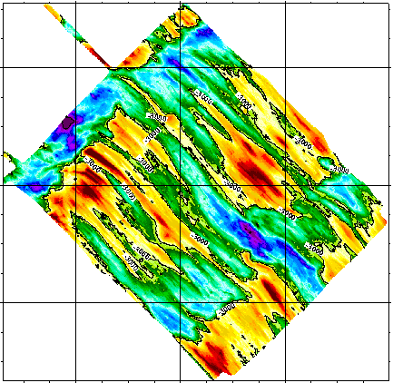
Dorsale sud-est indienne à 27°40’S - 120m
Simple
- Date ( Création )
- 1992-04-14
- Identificateur
- IFR_MBAN_DORSALES_INDIEN_SEIR27_BATHY_120_R
- Identificateur
- DOI:10.12770/f0ff85a1-9f28-456c-8a1b-70a3d8e93bce
- Reconnaissance
- Le projet s'inscrit dans le cadre du programme national Dorsales et représente la contribution française au projet Banques de données du programme InterRidge (cf. InterRidge News 1997,vol. 6/1 et 1999, vol. 8/1).
+33 (0)2 98.22.46.44
http://www.ifremer.fr/sismer/
- Thèmes Sextant Thèmes Sextant ( Thème )
-
- /Milieu physique/Bathymétrie/MNT
- GEMET - INSPIRE themes, version 1.0 GEMET - INSPIRE themes, version 1.0 ( Thème )
-
- Altitude
- Type de jeux de donnée ODATIS Type de jeux de donnée ODATIS ( Thème )
-
- /Données dérivées/Produits composites
- Thématiques - SIMM Thématiques - SIMM ( Thème )
-
- /Etat du Milieu/Géologie
- /Etat du Milieu/Bathymétrie
- Sous-regions marines Sous-regions marines ( Localisation )
-
- /Outre-mer/Océan Indien
- Thématiques - SIMM Thématiques - SIMM ( Thème )
-
- Recherche
- Limitation d'utilisation
- CC-BY (Creative Commons - Attribution)
- Contraintes d'accès
- Autres restrictions
- Contraintes d'utilisation
- Licence
- Autres contraintes
- Sauter D., Whitechurch H., Munschy M. and Humler E., 1991 - Periodicity in the accretion process on the Southeast Indian Ridge at 27˚40'S. Tectonophysics, 195, p. 47-64.
- Type de représentation spatiale
- Raster
- Dénominateur de l'échelle
- 25000
- Langue
- fr
- Jeu de caractères
- Utf8
- Catégorie ISO
-
- Altitude
))
- Nom du système de référence
- EPSG / WGS 84 (EPSG:4326) / 8.6
- Dimensions
- 2
- Noms des axes
- Axe - X
- Résolution
- 0.00122 degres
- Noms des axes
- Axe - Y
- Résolution
- 0.001079 degres
- Type de raster
- Surface
- Format (encodage)
-
-
(
)
-
(
)
- Ressource en ligne
- DOI de la campagne - RODRIGUEZ(1ER LEG) ( WWW:LINK )
- Ressource en ligne
- DOI de la campagne - RODRIGUEZ(2EME LEG) ( WWW:LINK )
- Ressource en ligne
-
DOI du jeu de données
(
WWW:LINK-1.0-http--metadata-URL
)
DOI du jeu de données
- Ressource en ligne
-
IFR_MBAN_DORSALES_INDIEN_SEIR27_BATHY_120_R
(
OGC:WMS
)
Bathymétrie à 120m de résolution
- Protocole
- FILE
- Nom
- IFR_MBAN_DORSALES_INDIEN_SEIR27_BATHY_120_R
- Description
- Bathymétrie 120m - format .tif
- Protocole
- COPYFILE
- Nom
- IFR_MBAN_DORSALES_INDIEN_SEIR27_BATHY_120_R_GRD
- Description
- Bathymétrie 120m - format .grd
- Niveau
- Jeu de données
- Généralités sur la provenance
-
Source(s) des données : Seabeam pendant la campagne Rodrigues I du N/O J. Charcot en 1984
Contrôle(s) qualité effectués : La navigation de la campagne Rodriguez obtenue à l’aide du système Transit, a été modifiée à l’aide du logiciel Cetis. Les données bathymétriques multifaisceaux Seabeam ont été recalées entre elles. Les données Seabeam ont été lissées: un cycle moyen sur cinq est conservé.
Méthode de calcul du paramètre représenté : interpolation au plus proche voisin
Logiciel de maillage utilisé : logiciel Cetis de l’IPG Strasbourg (Boulanger, M.O., Boulanger, D., Munschy, M., Sauter, D & Tissot, J.D., 1992 - CETIS : a new computer software to display marine geophysical data, improve navigation using Seabeam crossings, grid data and process images. XVII ème EGS, Edinburgh, avril 1992.)
- Description
- Pour les petits trous de 10 pixels, une simple interpolation linéaire a été utilisée. Pour les trous plus larges (comme les espaces entre les bandes Seabeam), nous avons utilisé une interpolation qui tient compte de la direction des structures bathymétriques de part et d’autre des trous (Sauter et al., 1996), ceci pour éviter d’avoir des isobathes aux courbes non réalistes. (Sauter D., Whitechurch H., Nafziger J.M., & Munschy M., 1996 - Segmentation and morphotectonic variations of the Central Indian Ridge between 21˚10'S and 22˚25'S. J. Geophys Res., 101, p. 20233-20256)
- But du processus
- Interpolation
Information sur le contenu
- Identifiant de la fiche
- f0ff85a1-9f28-456c-8a1b-70a3d8e93bce XML
- Langue
- fr
- Jeu de caractères
- Utf8
- Type de ressource
- Jeu de données
- Date des métadonnées
- 2020-08-31T11:24:30
- Nom du standard de métadonnées
- ISO 19115:2003/19139 - SEXTANT
- Version du standard de métadonnées
- 1.0
Aperçus
Étendue spatiale
Fourni par
