 Mon GéoSource
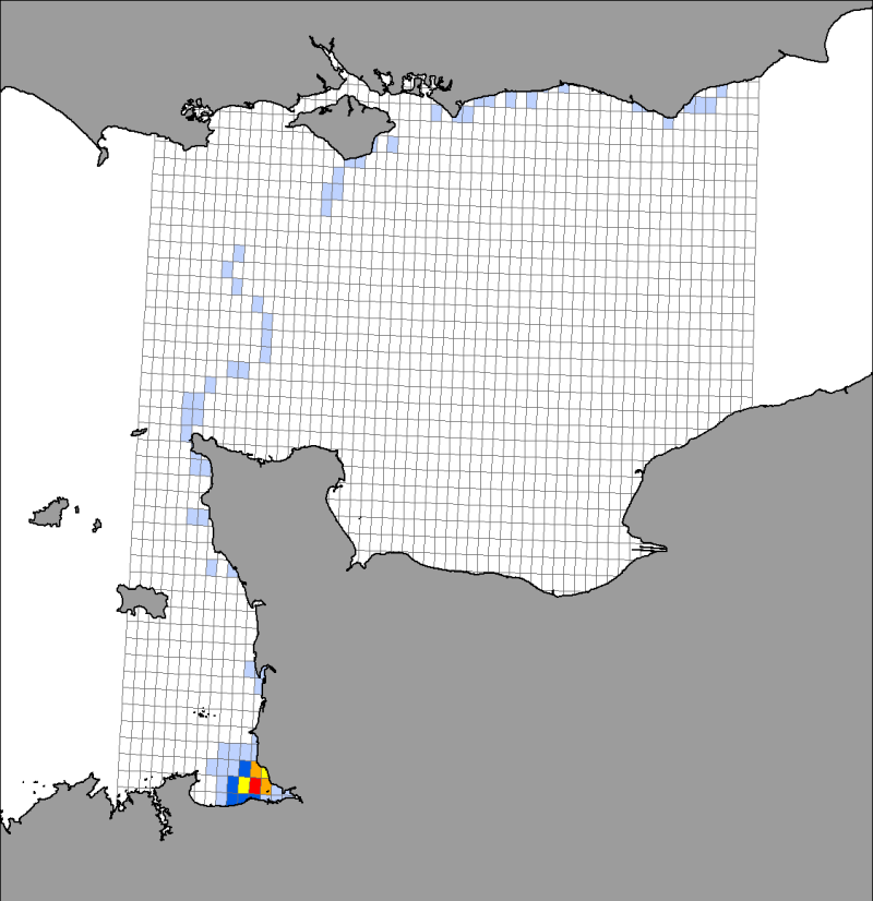
Distribution des localisations de phoques veaux marins suivis par balises Fastloc GPS / GSM à partir de la baie du Mont Saint-Michel entre 2006 et 2008
Distribution par mailles des localisations de 8 phoques veaux marins (Phoca vitulina) suivis par balises Fastloc GPS / GSM à partir de la baie du Mont Saint-Michel de 2006 à 2008
Simple
- Autres appellations ou acronymes
- Grid_Pv_ULR_telemetrie_BMSM_20062007
- Autres appellations ou acronymes
- RESEAU_PHOQUE_PV_TELEM_BMSM_P
- Date ( Création )
- 2010-11-29T00:00:00
- Identificateur
- RESEAU_PHOQUE_PV_TELEM_BMSM_P
- Forme de la présentation
- Carte numérique
- But
- Description des mouvements individuels, comportements en plongée et rythmes d'activité des phoques veaux marins sauvages das leur milieu naturel.
- Reconnaissance
- Vincent, C., Delayat, S., Elder, J.-F., Gautier, G., McConnell, B.J. & Ridoux, V. 2008. Suivi télémétrique de phoques veaux marins en baie du Mont-Saint-Michel et baie des Veys ; Suivis Fastloc¿ GPS/GSM 2006-2007. Rapport de l¿Université de La Rochelle pour la DIREN Basse-Normandie. Juin 2008. 64 pp.
- Reconnaissance
- L'acquisition des données brutes a été financée par la DIREN Basse Normandie, la Région Poitou-Charentes, la Zone Atelier de la Baie du Mont Saint Michel et l'Université de La Rochelle. Le Sea Mammal Research Unit (SMRU) ayant également offert 3 balises GPS/GSM lors des suivis réalisés en 2007/2008.
- Reconnaissance
- L'acquisition des données brutes a pu être réalisée grâce à la collaboration technique d'Aérobaie, du Sea Mammal Research Unit, de l'Office National de la Chasse et de la Faune Sauvage, du Zoo de La Flèche, du Centre de Recherches sur les Mammifères Marins, du CHENE, des Parcs Zoologiques de Paris et de la Bourbansais et de la Réserve Naturelle Nationale du Domaine de Beauguillot.
- Etat
- Finalisé
A l’origine de
Université de la Rochelle
-
Cécile Vincent
(
Enseignant-chercheur
)
05 46 45 82 64
LIENSS, UMR 6250 CNRS / Université de La Rochelle
,
Institut du Littoral et de l'Environnement
,
2 rue Olympe de Gouges
,
la Rochelle
,
17 000
,
France
05 46 50 76 57
05 46 45 82 64
Utilisateur
DREAL Basse Normandie
-
Denis Rungette
(
chef de la Division Biodiversité
)
10, boulevard du Général Vanier
,
BP60040
,
HEROUVILLE-SAINT-CLAIR Cedex
,
14006
,
France
02 50 01 84 41
- Fréquence de mise à jour
- Non planifiée
- Thèmes Sextant Thèmes Sextant ( Thème )
-
- /Milieu biologique/Espèces/Espèces rares, protégées ou en voie de disparition
- Mots clés ( Thème )
-
- Phoca vitulina
- phoque veau marin
- Mots clés ( Localisation )
-
- Baie du Mont Saint-Michel
- Manche
- Mots clés ( Discipline )
-
- télémétrie
- GEMET - INSPIRE themes, version 1.0 GEMET - INSPIRE themes, version 1.0 ( Thème )
-
- Répartition des espèces
- Sous-regions marines Sous-regions marines ( Localisation )
-
- /Métropole/Manche mer du Nord
- /Métropole/Mers Celtiques
- Thématiques - SIMM Thématiques - SIMM ( Thème )
-
- /Etat du Milieu/Espèces
- Recherche
- Type de jeux de donnée ODATIS Type de jeux de donnée ODATIS ( Thème )
-
- /Données dérivées/Produits composites
- Limitation d'utilisation
- Ces cartes ne peuvent être utilisées et reproduites que par les partenaires du "Réseau Phoques" et dans les limites précisées par la convention 08/2 210 441 entre Ifremer et partenaires de ce réseau.
- Contraintes d'accès
- Restreint
- Autres contraintes
- pour toute reproduction totale ou partielle de ces cartes, prendre contact au préalable pour obtenir une autorisation écrite
- Type de représentation spatiale
- Vecteur
- Dénominateur de l'échelle
- 100000
- Distance de résolution
- 50 metres,
- Langue
- fr
- Jeu de caractères
- Utf8
- Catégorie ISO
-
- Biote
- Description de l'environnement de travail
- ArcGIS 9.3
N
S
E
W
))
- Informations supplémentaires
- Huit phoques (dont 5 en janvier-mars 2006 et 3 en octobre 2007) ont été capturés puis équipés de balises GPS/GSM en baie du Mont Saint-Michel. Les localisations GPS transmises ont été recensées par mailles d'une grille de 0,05° de côté couvrant l'ensemble de la zone fréquentée par les phoques pendant leur suivi. La symbologie de la carte présentée est basée sur le pourcentage de localisations obtenus dans chacune de ces mailles.
- Nom du système de référence
- 4326
- Niveau topologie
- Géométrie seulement
- Type de géométries des objets
- Polygone
- Nombre d'objets géométriques
- 2736
Distributeur
- Ressource en ligne
- Télécharger le rapport Telemetrie ( WWW:LINK )
- Niveau
- Jeu de données
- Généralités sur la provenance
- Localisations des phoques obtenues à la surface de l'eau (ou à terre) à partir des balises "Series 9000 GPS Fastloc / GSM" construites par le Sea Mammal Research Unit (St-Andrews, UK). Recensement du nombre de localisations par maille carrée de 0,05° de coté d'un grid couvrant l'ensemble des déplacements des phoques (outil "Analyse par maille" d'ESRI - ArcGIS 9.3)
- Description
- Calcul du nombre total de localisations par maille
- But du processus
- représentation schématique de la distribution des localisations des phoques à terre comme en mer
- Période du processus
- 2010-11-15T00:00:00
- Identifiant de la fiche
- f24f9db0-fbc4-11df-9e8f-005056987263 XML
- Langue
- fr
- Jeu de caractères
- Utf8
- Type de ressource
- Jeu de données
- Date des métadonnées
- 2020-06-04T00:29:44
- Nom du standard de métadonnées
- ISO 19115:2003/19139 - SEXTANT
- Version du standard de métadonnées
- 1.0
Point de contact
Université de La Rochelle
-
Cécile Vincent
(
Enseignant chercheur
)
05 46 45 82 64
LIENSS, UMR 6250 CNRS/Université de La Rochelle
,
Institut du Littoral et de l'Environnement
,
2 rue Olympe de Gouges
,
la Rochelle
,
17000
,
France
05 46 50 76 57
05 46 45 82 64
Aperçus
Étendue spatiale
N
S
E
W
Fourni par

Ressources associées
Not available