 Mon GéoSource
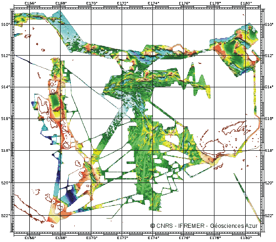
Bassin Nord Fidjien (Sud Ouest Pacifique) - 1000m
Bathymétrie du bassin Nord Fidjien produite à partir de plusieurs campagnes réalisées en 1985 et 1997
Simple
- Date ( Création )
- 2001-03-20
- Identificateur
- IFR_MBAN_DORSALES_PACIF_NORD_FIDJI_BATHY_1000_R
- Identificateur
- DOI:10.12770/f651de98-9478-4d42-9dc9-c0ec7a43ae87
- Reconnaissance
- Le projet s'inscrit dans le cadre du programme national Dorsales et représente la contribution française au projet Banques de données du programme InterRidge (cf. InterRidge News 1997,vol. 6/1 et 1999, vol. 8/1).
Editeur (publication)
Ifremer
+33 (0)2 98.22.46.44
http://www.ifremer.fr/sismer/
Centre IFREMER de Brest BP 70
,
PLOUZANE
,
29280
,
France
+33 (0)2 98.22.49.16
+33 (0)2 98.22.46.44
http://www.ifremer.fr/sismer/
- Thèmes Sextant Thèmes Sextant ( Thème )
-
- /Milieu physique/Bathymétrie/MNT
- GEMET - INSPIRE themes, version 1.0 GEMET - INSPIRE themes, version 1.0 ( Thème )
-
- Altitude
- Type de jeux de donnée ODATIS Type de jeux de donnée ODATIS ( Thème )
-
- /Données dérivées/Données de type modèle
- Thématiques - SIMM Thématiques - SIMM ( Thème )
-
- /Etat du Milieu/Bathymétrie
- Limitation d'utilisation
- CC-BY (Creative Commons - Attribution)
- Contraintes d'accès
- Autres restrictions
- Contraintes d'utilisation
- Licence
- Autres contraintes
- Ruellan, E., Auzende, J.M. and Lagabrielle, Y., (in prep). Extension, sea-floor spreading and propagating rift in the North Fiji Basin (SW Pacific). G3
- Type de représentation spatiale
- Raster
- Dénominateur de l'échelle
- 25000
- Langue
- fr
- Jeu de caractères
- Utf8
- Catégorie ISO
-
- Altitude
N
S
E
W
))
- Date de début
- 1985-01-01T00:00:00
- Date de fin
- 1997-12-31T00:00:00
- Nom du système de référence
- EPSG / WGS 84 (EPSG:4326) / 8.6
- Dimensions
- 2
- Noms des axes
- Axe - X
- Résolution
- 1000 mètres
- Noms des axes
- Axe - Y
- Résolution
- 1000 mètres
- Type de raster
- Surface
- Format (encodage)
-
-
(
)
-
(
)
- Ressource en ligne
-
IFR_MBAN_DORSALES_PACIF_NORD_FIDJI_BATHY_1000_R
(
OGC:WMS
)
Bathymétrie à 1000m de résolution
- Protocole
- FILE
- Nom
- IFR_MBAN_DORSALES_PACIF_NORD_FIDJI_BATHY_1000_R
- Description
- Bathymétrie 1000m - format .tif
- Ressource en ligne
-
DOI du jeu de données
(
WWW:LINK-1.0-http--metadata-URL
)
DOI du jeu de données
- Protocole
- COPYFILE
- Nom
- IFR_MBAN_DORSALES_PACIF_NORD_FIDJI_BATHY_1000_R_GRD
- Description
- Bathymétrie 1000m - format .mnt
- Ressource en ligne
- DOI de la campagne - KAIYO ( WWW:LINK )
- Ressource en ligne
- DOI de la campagne - MULTIPSO ( WWW:LINK )
- Ressource en ligne
- DOI de la campagne - NOFI ( WWW:LINK )
- Ressource en ligne
- DOI de la campagne - SEAPSO 1 ( WWW:LINK )
- Ressource en ligne
- DOI de la campagne - SEAPSO 2 ( WWW:LINK )
- Ressource en ligne
- DOI de la campagne - SEAPSO 3 ( WWW:LINK )
- Ressource en ligne
- DOI de la campagne - SEAPSO 4 ( WWW:LINK )
- Ressource en ligne
- DOI de la campagne - SOPACMAPS ( WWW:LINK )
- Niveau
- Jeu de données
- Généralités sur la provenance
- Sources : capteurs Seabeam 16 (N/O J. Charcot et Kaiyo), Furuno HS10-45 (N/O Yokosuka), Simrad EM12-dual (N/O Atalante); noms, dates des campagnes: Seapso 1985-86/1-2-3-4, Multipso 1987, Starmer-Kaiyo 1987-1988-1989, Starmer-Yokosuka 1990-1991, Sopacmaps 1993/1-2-3, Starmer-Nofi 1994, Starmer-Lauhavre 1997, fichiers globaux
- Description
- Traitement interactif (batmul) des données aberrantes sur les fichiers sources
- But du processus
- Interpolation au plus proche voisin
Information sur le contenu
No information provided.
- Identifiant de la fiche
- f651de98-9478-4d42-9dc9-c0ec7a43ae87 XML
- Langue
- fr
- Jeu de caractères
- Utf8
- Type de ressource
- Jeu de données
- Date des métadonnées
- 2020-08-31T10:59:54
- Nom du standard de métadonnées
- ISO 19115:2003/19139 - SEXTANT
- Version du standard de métadonnées
- 1.0
Aperçus
Capture.PNG
Étendue spatiale
N
S
E
W
Fourni par

Ressources associées
Not available