 Mon GéoSource
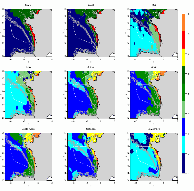
Evolution annuelle des paysages hydrologiques identifiés en Manche et Gascogne
L'analyse statistique utilisée (Analyse en composantes principales suivie d’une méthode de classification) permet d’identifier des groupes communs à l’ensemble des mois et de décrire l’évolution de ces groupes au cours de l’année. Les données utilisées permettent de disposer de tables mensuelles présentant les paramètres sélectionnés, calculés sur toute la zone géographique à une résolution de 0.1°.
Cette méthode permet d’identifier 10 paysages hydrologiques présents à différentes périodes de l’année, et caractérisés par des conditions hydrologiques homogènes.
Simple
- Date ( Création )
- 2011-07-01
- Identificateur
- habitats_pelagiques_atlantique9mois
- Reconnaissance
- Ifremer
- Thèmes Sextant Thèmes Sextant ( Thème )
-
- /Milieu biologique/Habitats
- GEMET - INSPIRE themes, version 1.0 GEMET - INSPIRE themes, version 1.0 ( Thème )
-
- Caractéristiques géographiques océanographiques
- Mots clés ( Thème )
-
- paysages hydrologiques; habitats pélagiques
- Sous-regions marines Sous-regions marines ( Localisation )
-
- /Métropole/Golfe de Gascogne
- /Métropole/Manche mer du Nord
- /Métropole/Mers Celtiques
- Contraintes d'accès
- Droit de propriété intellectuelle / Droit patrimonial
- Contraintes d'utilisation
- Droit de propriété intellectuelle / Droit patrimonial
- Restrictions de manipulation
- Non classifié
- Type de représentation spatiale
- Raster
- Distance de résolution
- 0.1 degrès
- Langue
- fr
- Jeu de caractères
- Utf8
- Catégorie ISO
-
- Informations géoscientifiques
- Océans
))
- Informations supplémentaires
-
Grp 1
Zone du large (au delà des 100m), très eu influencée par les panaches dessalés, et non stratifiée, présente uniquement l'hiver et en début de printemps. Cette zone est également observée en novembre sur le talus, pour lequel la rupture de stratification est la plus rapide, avec des
températures de fond froides et une faible production phytoplanctonique en surface.
Grp 2
Eaux du large au mois de mai, en début de stratification avec présence du bloom printanier.
Grp 3
Zone de stratification intermédiaire de fin de printemps, avec une thermocline encore
relativement peu profonde et peu intense. Cette zone concerne également les eaux du large, ainsi que le talus au nord et l'upwelling de Galice au sud, deux zones qui conservent ces caractéristiques de stratification limitées tout au long de l'été, en raison des ondes internes dans le
premier cas, et du vent responsable de l'upwelling dans le second. Ces mêmes phénomènes expliquent le maintien d'une production plus forte que pour le groupe 4, très appauvri en été.
Grp 4
Eaux du large au coeur de l'été, avec une stratification forte, une thermocline marquée et relativement profonde, et une absence de production phytoplanctonique. Cette situation se maintient jusqu'en octobre pour certaines zones du large.
Grp 5
Eaux du large se dont la stratification diminue, d'octobre à novembre.
Grp 6
Zone du milieu de plateau dans le sud du golfe de Gascogne, ainsi qu'en entrée de Manche, présentant la stratification la plus forte au cours de l'été, du fait d'un réchauffement important et d'eau relativement dessalée en surface en comparaison aux groupes du large décrits ci-dessus.
Grp 7
Bande côtière, relativement dessalée, non stratifiée, présente de mai à juin dans les zones sous l'influence du mélange par la marée (nord du golfe de Gascogne et Manche), et assez chaude sur
l'ensemble de la colonne d'eau car sous l'influence du réchauffement en surface.
Grp 8
Bande côtière entre les isobaths 50m et 100m, faiblement dessalée, avec des concentrations en MES conséquentes du fait de l'apport par les panaches et de la remise en suspension hivernale, non stratifiée, présente sur le nord de la zone jusqu’en mai, avant le réchauffement saisonnier.
Grp 9
Panaches d’hiver et de début de printemps, avec des eaux dessalées, riches en MES et des températures inférieures à 10°C.
Grp 10
Panaches le reste de l'année (été-automne), avec des températures beaucoup plus élevées et des
eaux relativement moins turbides.
- Nom du système de référence
- EPSG / WGS84 géographiques / 7.4
- Format (encodage)
-
-
Esri grid
(
ArcGIS 9.3.1
)
-
Esri grid
(
ArcGIS 9.3.1
)
- Ressource en ligne
- site internet Ifremer dédié à la Directive Cadre Stratégie pour le Milieu Marin ( WWW:LINK )
- Ressource en ligne
-
carthothèque DCSMM
(
WWW:LINK
)
Distribution des biotopes principaux de la colonne d'eau (pélagiques)
- Niveau
- Jeu de données
- Généralités sur la provenance
-
Afin de décrire les propriétés physiques influant sur la répartition spatiale des populations, des mesures in situ de salinité et de température sur toute la colonne d’eau sont utilisées.
Sur la façade atlantique, la climatologie BOBYCLIM (http://www.ifremer.fr/climatologie-gascogne/index.php) rassemble l’ensemble des mesures in situ collectées lors des campagnes océanographiques depuis plus d’un siècle.
Des estimations par interpolation verticale permettent d’obtenir des moyennes mensuelles sur toute la colonne d’eau (de 0 à -4000 mètres) et à une résolution spatiale de 0.1°. Un pourcentage de confiance, dépendant du nombre de mesures utilisées pour l’interpolation, est calculé afin de décrire la qualité des estimations. Dans cette étude, seules les données avec un pourcentage de confiance supérieur à 60 % ont été retenues. En raison du nombre élevé de valeurs manquantes, les mois de décembre, janvier et février n’ont pas été pris en compte dans l’analyse.
Pour les autres mois, afin de conserver un maximum d’information, notamment en milieu côtier, les valeurs manquantes ont été remplacées par une méthode d’imputation par analyse en
composantes principales, prenant en compte à la fois les corrélations entre variables et les similitudes entre pixels.
Par ailleurs, le nombre de mesures de salinité étant plus faible, le calcul de la densité à partir de la température et de la salinité n'est pas toujours cohérent, par conséquent le calcul de ces trois indices n’est basé que sur la température. Cette limite ne permet pas de décrire les processus hydrologiques uniquement liés à la stratification haline, concernant notamment les zones très côtières en périodes hivernales ou automnales.
En outre, les données de type climatologique mensuelle utilisées ici ne permettent pas de capturer la variabilité associée aux structures hydrodynamiques à méso-échelle, telles que les
tourbillons, les zones de front et les upwelling, qui peuvent également expliquer la distribution spatio-temporelle de certaines populations.
- Description
-
Outre la température, qui joue un rôle direct sur la production primaire et l’ensemble du réseau trophique, d'autres caractéristiques telles que la stratification de la colonne d'eau ou la salinité, reflétant l'influence des panaches, ont un impact fort sur la distribution des communautés pélagiques.
Les indices hydrodynamiques sélectionnés dans cette étude sont les suivants :
1) Indices de stratification de la colonne d’eau :
- déficit d’énergie potentielle (PhiT, kg.m-1.s-2) : énergie nécessaire pour homogénéiser (en température, en salinité ou en densité) la colonne d’eau,
- gradient maximum vertical en température (GradTmax, °C.m-1) ou en densité (kg.m-3.m-1),
- profondeur de la couche de mélange (thermocline, pycnocline ou halocline) (Zm, m),
2) Indice « panaches fluviaux » : salinité de surface (SS)
3) Température de fond (BT, °C)
Les indices hydrologiques sont calculés selon les formules proposées (Huret M., Struski C, Léger F, Petitgas P., Lazure P. and Sourisseau M. (2009). Modélisation couplée physique-biogéochimie du golfe de Gascogne sur la période 1971-2007. R.INT.DOP/EMH/ 2009-01). Pour la température de fond, une profondeur limite de 200 mètres a été fixée. Pour les autres indices (déficit d’énergie potentielle, gradient vertical maximum de température et profondeur de la couche de mélange), un seuil de 100 mètres a été utilisé.
La turbidité peut également jouer un rôle sur la distribution spatiale des populations pélagiques. En référence aux espèces ichtyologiques, il peut être judicieux d'élargir la notion de biotope en prenant en compte le plancton, constituant l'alimentation de certaines populations ichtyologiques, et donc structurant leur distribution. C’est pourquoi l’ajout du paramètre Chlorophylle-a a été envisagée dans cette étude, en l'absence de données suffisamment synoptiques pour le zooplancton.
- But du processus
- Méthodologie d'identification des paysages hydrologiques
- Identifiant de la fiche
- ff518971-490c-4f55-9960-cfcb98d7bfa6 XML
- Langue
- fr
- Jeu de caractères
- Utf8
- Type de ressource
- Collection de données
- Nom du niveau de hiérarchie
- Ensemble de jeux de données
- Date des métadonnées
- 2020-06-04T00:27:53
- Nom du standard de métadonnées
- ISO 19115:2003/19139 - SEXTANT
- Version du standard de métadonnées
- 1.0
Aperçus
Étendue spatiale
Fourni par
