 Mon GéoSource
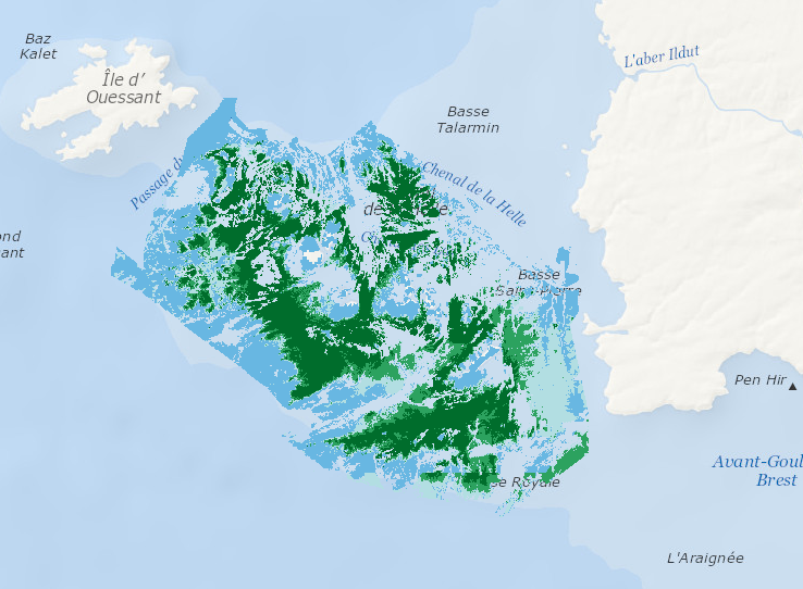
Kelp species L. digitata and L. hyperborea mapping along Molène Archipelagos (France)
Data represents percentage cover of kelp forest as well as biomass of the 2 main species: L. digitata and L. hyperoborea.
The used approach consists in firstly establishing surveys and appropriate processing methods in order to provide a detailed underwater topography of the area and to accurately delineate hard substrates (bedrock) potentially colonized by kelp. Secondly, a habitat suitability model is fitted for each species on some carefully selected field stations, measuring kelp presence/absence and biomass. Predictive maps are produced, based on hard substrate areas previously delineated.
Simple
- Date ( Publication )
- 2015-01-01T00:00:00
- Identificateur
- IFR_MOLENE_BIOMASSE_MINMEDMAX_PRESENCE_ABSENCE
- Identificateur
- DOI:10.12770/4adbe32a-8c81-4c18-8da3-4c361889820c
- Reconnaissance
- Bajjouk T., Rochette S., Laurans M. Ehrhold A., Hamdi A. and Le Niliot Ph. (2015). Multi-approach mapping to help spatial planning and management of the kelp species L. digitata and L. hyperborea: Case study of the Molène Archipelago, Brittany. Journal of Sea Research. 100:2-21
02 98 22 45 48
- GEMET - INSPIRE themes, version 1.0 ( Thème )
-
- Habitats and biotopes
- Thèmes Sextant ( Thème )
-
- /Biological Environment/Habitats
- Ocean Hackathon - Ville ( Localisation )
-
- Brest
- Sous-regions marines ( Localisation )
-
- /Metropolitan France/Celtic Seas
- Thématiques - SIMM ( Thème )
-
- /Environmental Status/Habitats
- Type de jeux de donnée ODATIS ( Thème )
-
- /Processed data/Model outputs
- Limitation d'utilisation
- Creative Commons license to apply : Attribution + Non Commercial + No Derivs (BY-NC-ND) : http://creativecommons.org/licenses/?lang=en
- Contraintes d'accès
- Autres restrictions
- Contraintes d'utilisation
- Droit d’auteur / Droit moral (copyright)
- Autres contraintes
- unrestricted
- Type de représentation spatiale
- Raster
- Distance de résolution
- 5 meter
- Langue
- en
- Jeu de caractères
- Utf8
- Catégorie ISO
-
- Environnement
))
- Nom du système de référence
- EPSG / WGS 84 (EPSG:4326) / 8.6
- Dimensions
- 2
- Noms des axes
- Axe - X
- Nombre de pixel
- 5011
- Noms des axes
- Axe - Y
- Nombre de pixel
- 3044
- Type de raster
- Surface
- Disponibilité des paramètres de transformation
- Oui
- Format (encodage)
-
-
(
)
-
(
)
- Ressource en ligne
-
IFR_MOLENE_BIOMASSE_MINMEDMAX_LD
(
OGC:WMS
)
Biomass - Laminaria digitata
- Protocole
- COPYFILE
- Nom
- IFR_MOLENE_BIOMASSE_MINMEDMAX_LD
- Description
- Biomass - Laminaria digitata
- Ressource en ligne
-
IFR_MOLENE_BIOMASSE_MINMEDMAX_LH
(
OGC:WMS
)
Biomass - Laminaria hyperborea
- Protocole
- COPYFILE
- Nom
- IFR_MOLENE_BIOMASSE_MINMEDMAX_LH
- Description
- Biomass - Laminaria hyperborea
- Ressource en ligne
-
IFR_MOLENE_PRESENCE_ABSENCE_LD
(
OGC:WMS
)
Presence/Absence - Laminaria digitata
- Protocole
- COPYFILE
- Nom
- IFR_MOLENE_PRESENCE_ABSENCE_LD
- Description
- Presence/Absence - Laminaria digitata
- Ressource en ligne
-
IFR_MOLENE_PRESENCE_ABSENCE_LH
(
OGC:WMS
)
Presence/Absence - Laminaria hyperborea
- Protocole
- COPYFILE
- Nom
- IFR_MOLENE_PRESENCE_ABSENCE_LH
- Description
- Presence/Absence - Laminaria hyperborea
- Ressource en ligne
-
DOI du jeu de donnée
(
WWW:LINK-1.0-http--metadata-URL
)
DOI du jeu de donnée
- Niveau
- Jeu de données
Résultat de conformité
- Date ( Publication )
- 2010-12-08
- Explication
- See the referenced specification
- Généralités sur la provenance
-
A habitat distribution modelling approach was used to model the spatial distribution of the two main species of kelp forests along Molène archipelagos (France).
Lineage:
Data represents percentage cover of kelp forest as well as biomass of the 2 main species: L. digitata and L. hyperoborea.
The used approach consists in firstly establishing surveys and appropriate processing methods in order to provide a detailed underwater topography of the area and to accurately delineate hard substrates (bedrock) potentially colonized by kelp. Secondly, a habitat suitability model is fitted for each species on some carefully selected field stations, measuring kelp presence/absence and biomass. Predictive maps are produced, based on hard substrate areas previously delineated.
Type of occurrence data used:
In situ data were acquired in the period from late summer to early autumn. Information on the presence/absence of Laminaria species was acquired by towing a high definition video. Species-specific biomass were sampled at low tide for the intertidal areas and by Scuba diving for the sub-tidal areas.
Environmental covariates/explanatory variables:
Presence–absence of L. digitata distribution was best determined through the combined effects of depth, sediment proximity along current direction, benthic position index (BPI), immersion rate and winter temperature.
The sub-model for biomass of L. digitata where present, was predicted using the additional contribution of several variables, with light being the most important (55.62% of deviance explained) and its interactions withwave exposure and spring temperature. Total suspended matter contributed little and only then through the interaction with light.
The best model that explained 78.89% of deviance for the presence of L. hyperborea included depth, winter temperature, sediment proximity along current direction and BPI
Biomass where L. hyperborea was present was mainly modeled by the same predictors as presence/absence
Algorithm/modelling approach:
Kelp biological response (presence/absence or biomass) was estimated using Generalized Additive Models (GAM)
- Identifiant de la fiche
- 4adbe32a-8c81-4c18-8da3-4c361889820c XML
- Langue
- en
- Jeu de caractères
- Utf8
- Type de ressource
- Jeu de données
- Date des métadonnées
- 2019-02-06T15:37:23
- Nom du standard de métadonnées
- ISO 19115:2003/19139 - SEXTANT
- Version du standard de métadonnées
- 1.0
02 98 22 45 48
Aperçus
Étendue spatiale
Fourni par
