 Mon GéoSource
Shapefile
Type of resources
Available actions
Topics
INSPIRE themes
Keywords
Contact for the resource
Provided by
Years
Formats
Representation types
Update frequencies
Scale
-
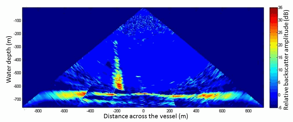
Acoustic water column data acquired in 2009 during the MARMESONET marine expedition led to establish an accurate spatial distribution of gas emissions on the scale of the Sea of Marmara. The present database is composed of a surface shape file (.shp) dedicated to GIS applications. This seafloor surface represents the insonified area within which gas emissions occurred for more than 1 month of survey, from 4 November 2009 to 14 December 2009; as displayed in Figure 4 of Dupré et al. 2015 (Dupré S, Scalabrin C, Grall C, Augustin AH, Henry P, Sengör AMC, Görür N, Çagatay N, Géli L (2015) Tectonic and sedimentary controls for widespread gas emissions in the Sea of Marmara. Results from systematic, shipborne multibeam echosounder water column imageries. Journal of Geophysical Research 120 (5):2891-2912. doi:10.1002/2014JB011617). This publication investigated and discussed the relationship between fluid emissions at the seafloor with the fault network (active and inactive faults) and the sedimentary environment (nature, thickness and related-processes).
-

Fichier représentant le zonage du PLU et des cartes communales pour la commune possédant ce type de document d'urbanisme.
-
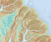
Géomorphologie du canyon des Sables d'Olonne au canyon d'Ars (projet CoralFISH, 2012). Echelle 1/100 000. Bourillet Jean-Francois, De Chambure Laurent, Loubrieu Benoit,Breton Cécile,MazéJean-Pierre. Référencesbibliographiques: Bourillet Jean-Francois, De Chambure Laurent, Loubrieu Benoit (2012). Sur les traces des coraux d'eau froide du golfe de Gascogne. 8 cartes bathymorphologiques et géomorphologiques au 1/100.000 / Cold water corals of the Bay of Biscay: 8 bathymorphological and geomorphological maps at 1:100,000. Editions Quae. https://archimer.ifremer.fr/doc/00320/43162/De Chambure Laurent, Bourillet Jean-Francois, Bartel Claire (2013). Geomorphological classification in Bay of Biscay. Morpho-sedimentary mapping of the seabed in selected areas. REM/GM/LES 2013. https://archimer.ifremer.fr/doc/00249/36033/
-
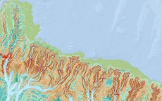
Géomorphologie du canyon de Blackmud au canyon de Douarnenez (projet CoralFISH, 2012). Echelle 1/100 000. Bourillet Jean-Francois, De Chambure Laurent, Loubrieu Benoit,Breton Cécile,MazéJean-Pierre. Référencesbibliographiques: Bourillet Jean-Francois, De Chambure Laurent, Loubrieu Benoit (2012). Sur les traces des coraux d'eau froide du golfe de Gascogne. 8 cartes bathymorphologiques et géomorphologiques au 1/100.000 / Cold water corals of the Bay of Biscay: 8 bathymorphological and geomorphological maps at 1:100,000. Editions Quae. https://archimer.ifremer.fr/doc/00320/43162/De Chambure Laurent, Bourillet Jean-Francois, Bartel Claire (2013). Geomorphological classification in Bay of Biscay. Morpho-sedimentary mapping of the seabed in selected areas. REM/GM/LES 2013. https://archimer.ifremer.fr/doc/00249/36033/
-
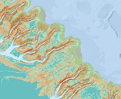
Géomorphologie du canyon de Penmarc'h au canyon de Saint-Nazaire (projet CoralFISH, 2012). Echelle 1/100 000. Bourillet Jean-Francois, De Chambure Laurent, Loubrieu Benoit,Breton Cécile,MazéJean-Pierre. Référencesbibliographiques: Bourillet Jean-Francois, De Chambure Laurent, Loubrieu Benoit (2012). Sur les traces des coraux d'eau froide du golfe de Gascogne. 8 cartes bathymorphologiques et géomorphologiques au 1/100.000 / Cold water corals of the Bay of Biscay: 8 bathymorphological and geomorphological maps at 1:100,000. Editions Quae. https://archimer.ifremer.fr/doc/00320/43162/De Chambure Laurent, Bourillet Jean-Francois, Bartel Claire (2013). Geomorphological classification in Bay of Biscay. Morpho-sedimentary mapping of the seabed in selected areas. REM/GM/LES 2013. https://archimer.ifremer.fr/doc/00249/36033/