 Mon GéoSource
Observation
Type of resources
Available actions
Topics
INSPIRE themes
Keywords
Provided by
Years
Formats
Representation types
Update frequencies
status
Scale
-

The definitive coastal information system, Quadrige stores coastal observation and monitoring network data. In order to manage coastal monitoring data, Ifremer developed the Quadrige² information system. Quadrige is one element of the Water Information System (SIE) http:// www.eaufrance.fr, et à ce titre, contribue aux travaux du Secrétariat d'Administration National des Données Relatives à l'Eau (SANDRE) http://www.sandre.eaufrance.fr. Quadrige Marine Zones is a reference source unique to the Quadrige system. It is used to break down the coast of the French mainland and overseas territories into large areas and to connect each one with observation and monitoring locations.
-

In order to manage coastal monitoring data, Ifremer has developed the Quadrige information system which connects a database to a wide array of tools for interpreting and designing information products. Quadrige is just one element of the Water Information System (SIE) www.eaufrance.fr and, as such, contributes toward the work of the French National Adminitrative Service for Water-Related Data (SANDRE) www.sandre.eaufrance.fr. The main aim of the Quadrige thematic databank is to manage and enhance data from coastal observation and monitoring networks. On a national level, Quadrige is today designated by the French Environment Ministry as the definitive information system for coastal waters, and the tool is therefore common to all of those working in the marine environment sector. The Quadrige databank is composed of data from the Quadrige database and products described or made available on the Envlit website. The Quadrige database contains results about most physical, chemical and biological environmental description parameters. The first data for example dates back to 1974 for the parameters relating to general water quality and contaminants, 1987 for phytoplankton and phycotoxins, 1989 for microbiology, from the early 2000s for the benthic zone. The data is permanently being updated. In Quadrige, an observation location is a geographical location where observations, measurements and/or samples will be taken. These locations can be located in a unique way thanks to their appearance on a map (polygon, line or point). A measurement location can be used by multiple programmes.
-
Since 2008, the Coastal Chemical Contamination Observation Network (ROCCH) has taken over from RNO (French National Observation Network for Quality in Marine Environments), which had existed since 1974. ROCCH aims to meet national, community and international obligations relating to monitoring chemicals in marine environments. It is therefore more of a control network than a heritage network as RNO once was. The backbone of ROCCH is to apply the European Water Framework Directive (WFD) and to meet the obligations set out in OSPAR Conventions and in Barcelona. As the WFD insisted on decentralization, ROCCH has gone from having just one project leader (the Ministry for the Environment) to having many decision-makers (water agencies, DIREN etc.). Chemical analyses are no longer conducted by Ifremer alone, but are attributed to other partners following calls for tender. ROCC also includes the monitoring of chemicals in shellfish production areas for the Food safety agency (DGAL) and the Ministry for Agriculture and Fisheries. Monitoring focuses on the three regulated metals: mercury, lead and cadmium in the given areas. Monitoring of these chemical contaminants is conducted in the three marine matrices: water, biota and sediment. Testing also includes imposex, the biological effect of tributyltin (TBT), as required by the OSPAR convention.
-
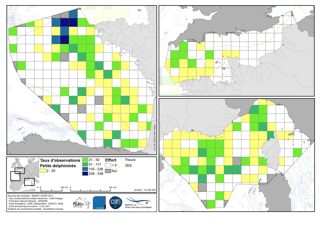
Occurrence rate by observation number for 100km of effort in each 40km mesh in the French mainland EZE in the winter of 2011/2012 and the summer of 2012. Description of the attribute table: survey : campaign Type: observation type Mesh: mesh size in kilometers _no_maille : mesh number The following fields correspond to the calculation of the occurrence rate for the observation number for 1000km of effort for each species or group of species : - [marsouin] common porpoise - [grdDauph] bottlenose dolphin - [lagenor] White-beaked dolphin - [pttDelph] : common dolphin and Striped dolphin - [globiceph] : Long-finned pilot whale + Risso's dolphin - [cakobab] : Sperm whale+ kogias + Beaked whales - [balenopt] : Fin whale + Minke whale + blue whale - [phoque] seal (grey + harbour)
-
The French national network (REMI) includes a regular monitoring system and a warning system: - The regular monitoring system checks that the level of microbiological contamination in each production area remains within the limits set by the classification defined in the prefectural decree and tests unusual occurrences of contamination. - The warning system is triggered when results of the monotoring programme exceed or are at risk of exceeding the norms defining the quality classes and thresholds, or in case of contamination risk (pollution spillage, storms, etc.), or even in the case of a suspected or confirmed epidemic in shellfish.
-
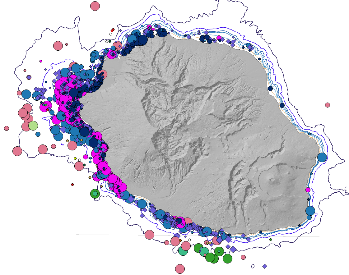
Cartographie des positions des observations des différentes espèces de cétacés autour de l'île de La Réunion par année.
-
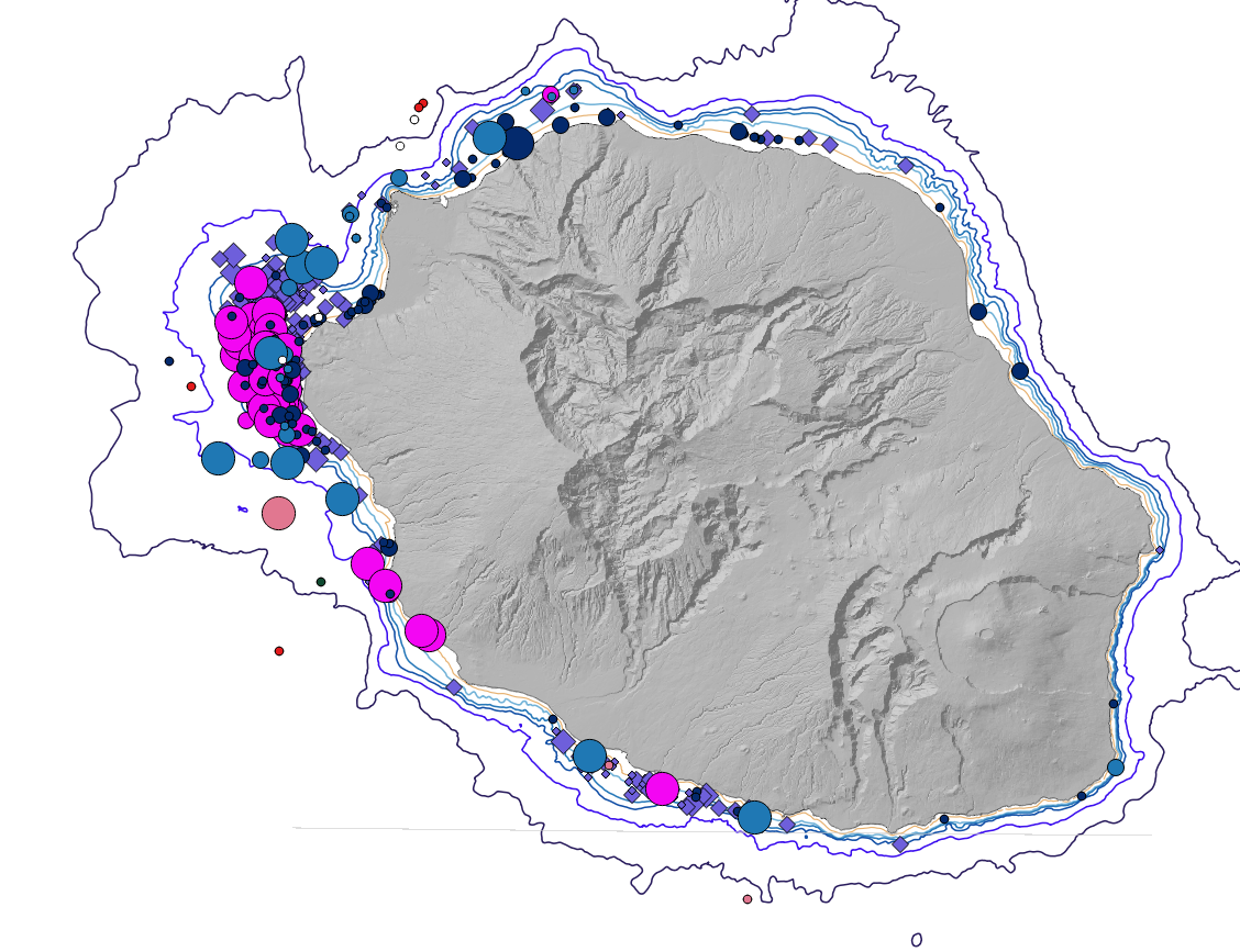
Cartographie des positions des observations des différentes espèces de cétacés autour de l'île de La Réunion en 2014
-
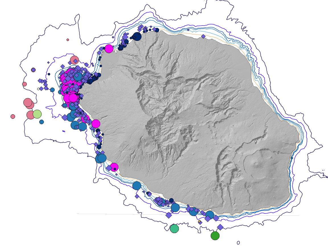
Cartographie des positions des observations des différentes espèces de cétacés autour de l'île de La Réunion en 2011
-
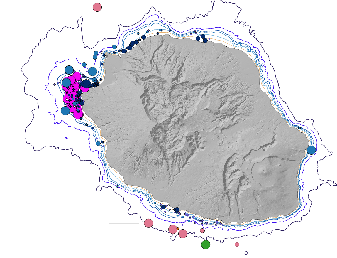
Cartographie des positions des observations des différentes espèces de cétacés autour de l'île de La Réunion en 2009
-
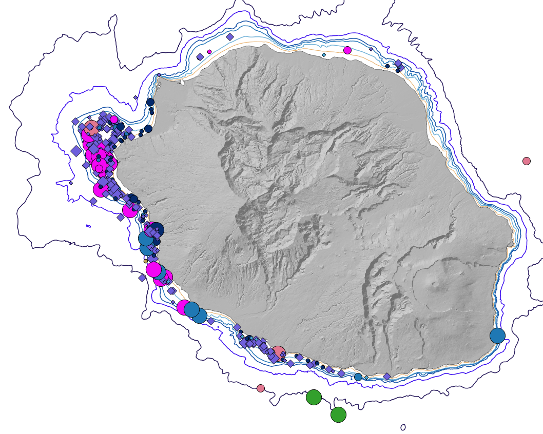
Cartographie des positions des observations des différentes espèces de cétacés autour de l'île de La Réunion en 2013