 Mon GéoSource
/Métropole/Méditerranée occidentale
Type of resources
Available actions
Topics
INSPIRE themes
Keywords
Contact for the resource
Provided by
Years
Formats
Representation types
Update frequencies
status
Scale
Resolution
-
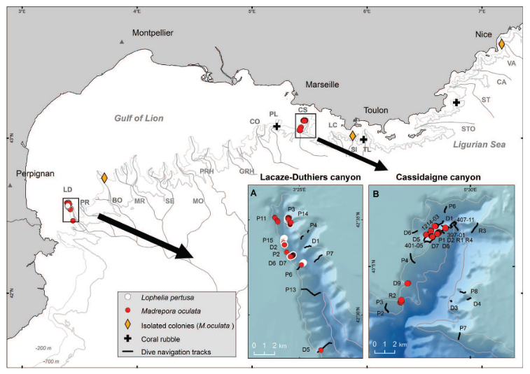
In the Mediterranean deep-sea two scleractinian species, Lophelia pertusa (= Desmophyllum pertusum) and Madrepora oculata, make up the dominant structure-forming corals. The Lacaze-Duthiers canyon is the only French Mediterranean canyon where the two species L. pertusa and M. oculata have been observed living together in large quantities, the situation generally described for the biocoenosis of cold-water corals (CWC). In this canyon large colonies (more than 40 cm) of both species of scleractinians were observed at depths ranging from 246 m to 541 m at the head of the canyon and its western flank. The second canyon is the Cassidaigne canyon, where M. oculata seems to be the only structure-forming scleractinian there. The largest concentration of M. oculata colonies was observed on the west flank of the canyon along a crest at depths ranging from 200 to 210 m. Mature M. oculata colonies attained heights up to 40 cm. M. oculata were observed in three other canyons: Bourcart, Sicié and Var. In the Bourcart canyon, M. oculata was observed on a shelf of hard substratum at 331 m depth. Several single branches protruded from a slab. In the Sicié canyon a 15-cm colony of M. oculata was observed at 255 m depth, while in the Var canyon, three young branches 2 cm long were seen growing at 350 m depth on a wall of hard rock. Data linked to the publication Fabri et al, 2014. https://doi.org/10.1016/j.dsr2.2013.06.016.
-

Le substrat est cartographié à partir de la granulométrie de 31 des 36 lagunes méditerranéennes françaises classées "Masses d'eau de transition" au titre de la DCE. Cette carte est issue de la compilation et traitement des données stationnelles disponibles.
-

L’état trophique est cartographié d'après l’indicateur de qualité physico-chimique qui constitue un paramètre de soutien de la DCE. Il s’appuie sur les paramètres clés de l’eutrophisation, l’azote total (Nt), le phosphore total (Pt), l’azote inorganique dissou (NID) et le phosphore inorganique dissout (PID). La carte concerne les 36 lagunes méditerranéennes françaises classées "Masses d'eau de transition" au titre de la DCE sur la période estivale 2012-2017.
-

Le critère Biologie intègre uniquement les données Macrophytes par manque de connaissance et de données sur les autre compartiments. La carte concerne 33 des 36 lagunes méditerranéennes françaises classées "Masses d'eau de transition" au titre de la DCE. La données est hiérarchisée en 3 sous-niveaux successifs permettant de caractériser l'abondance de végétation puis le groupe taxonomique dominant et enfin le peuplement en cas de végétation mixte.
-

La zone biologique est cartographiée via le pourcentage de lumière disponible au fond sur 32 des 36 lagunes méditerranéennes françaises classées "Masses d'eau de transition" au titre de la DCE. La lumière disponible est calculée à partir de la profondeur et du coefficient d'atténuation de la lumière dans l'eau sur la période printemps-été 2012-2017.
-
L'hydrodynamisme est cartographié via la tension de cisaillement au fond sur 31 des 36 lagunes méditerranéennes françaises classées "Masses d'eau de transition" au titre de la DCE. Elle est approximée à partir de la profondeur, de la distance à la côte et de la direction moyenne et intensité moyenne du vent la période printemps-été 2012-2017.
-
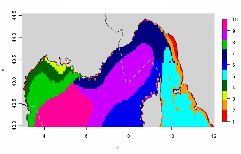
The distribution of hydrological landscapes is determined by a method of comparing multi-tables, to identify groups of individuals with similar variability of hydrological conditions during the year. The data used provides monthly tables showing the five selected physical parameters (SS, Phi, SST, MES et CHLA), calculated over the entire geographical area, a common resolution of 0.05°. This method identifies 10 hydrological landscapes showing a similar annual variability of hydrological conditions.
-
Censuses of nutrient salt monitoring stations in the western Mediterranean sub-region (1962 to 2010)
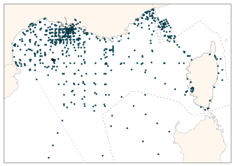
The consolidated database shows the spatial distribution of sampling effort by French and Monaco oceanographic campaigns. The measures are divided between the mouth of the Rhone, the Gulf of Lions, and Ligurian and Provence seas. The database contains 55 campaigns or time series, over 5 decades from 1962 to 2010. 28 are oceanographic campaigns of spatial strategy (some were revisited), 14 of temporal strategy, 2 of spatio-temporal strategy, and 1 one-time campaign. In total, it has 24,886 entries including: 19,027 nitrate data - 13,826 nitrite data - 11,452 ammonium data – 20,936 phosphates data – 14,605 silicates data. The majority (92%) of associated temperature and salinity data is available.
-
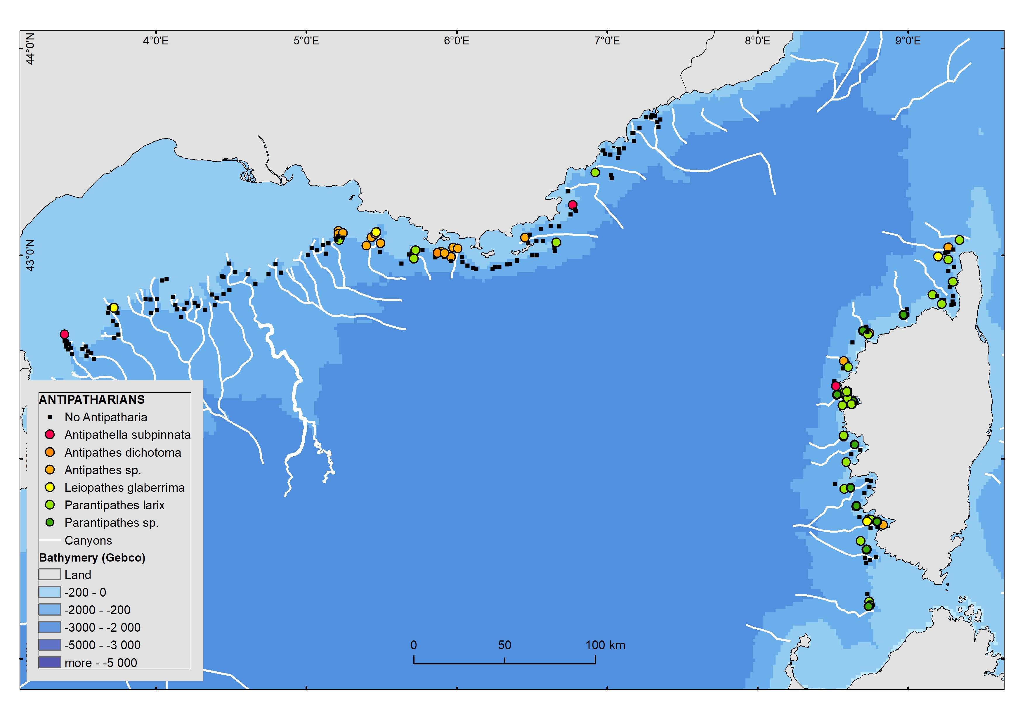
Data were extracted from videos recorded during MEDSEACAN_2009 and CORSEACAN_2010 cruises operated by Comex (Aamp funding). Underwater vehicles were either Achille ROV or Remora submersible. Video analyses were realized by Ifremer and GIS posidonie.
-
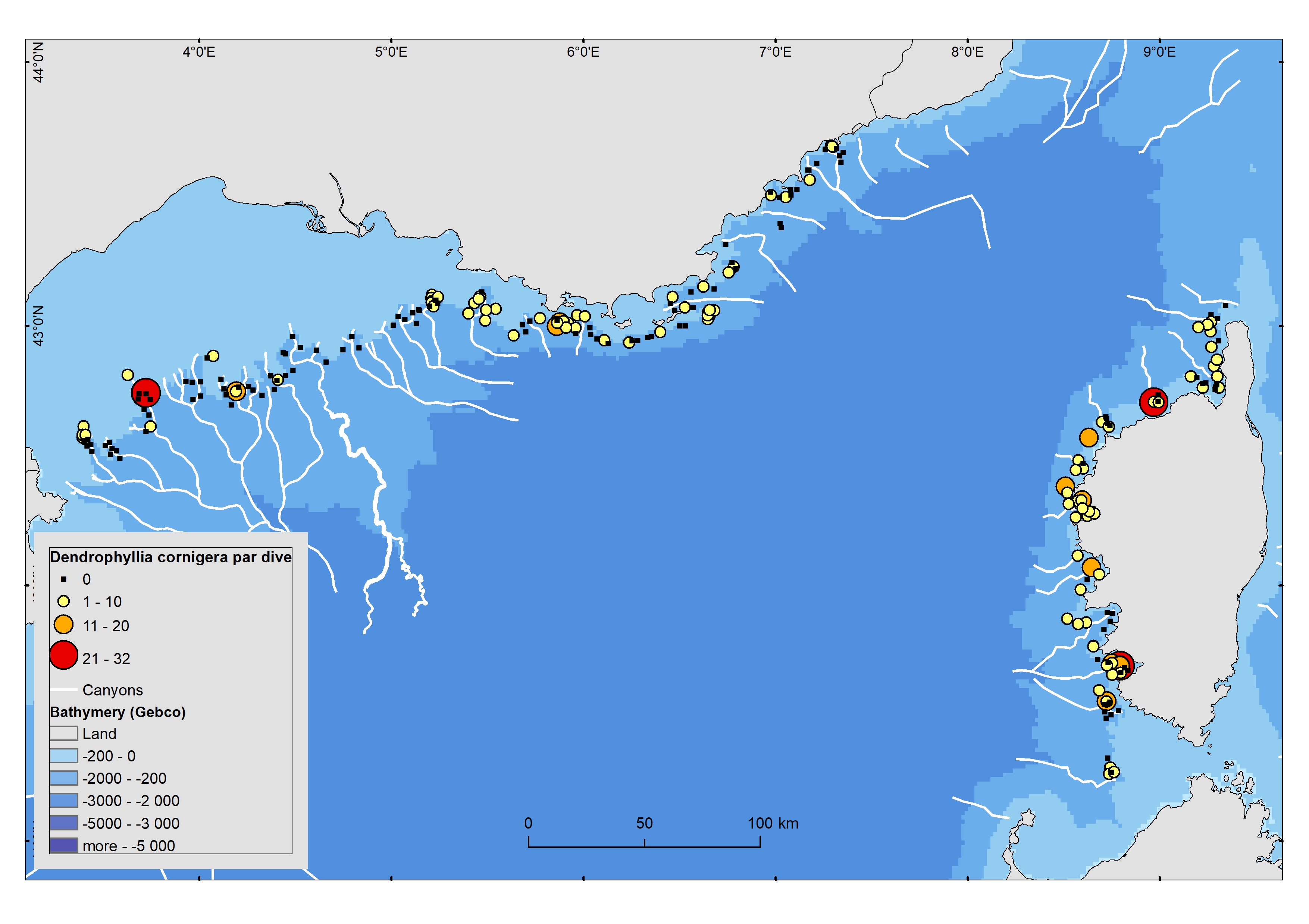
Data were extracted from videos recorded during MEDSEACAN_2009 and CORSEACAN_2010 cruises operated by Comex (Aamp funding). Underwater vehicles were either Achille ROV or Remora submersible. Video analyses were realized by Ifremer and GIS posidonie.