 Mon GéoSource
5000
Type of resources
Available actions
Topics
INSPIRE themes
Keywords
Contact for the resource
Provided by
Years
Formats
Representation types
Update frequencies
status
Scale
Resolution
-
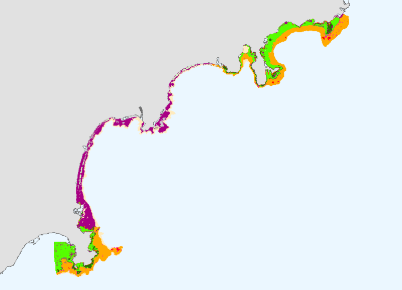
This mapping of marine biocenoses between 0 and 50m depth covers 75km of coastline between Antibes and Cap d'Ail.
-
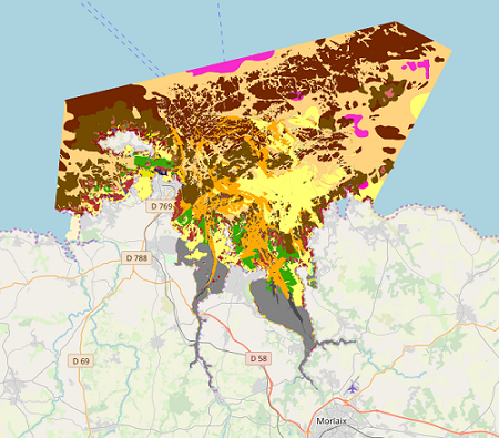
Map of benthic habitat synthesis of the Natura 2000 site FR5300015 - Bay of Morlaix is the result of the fusion and harmonization of five cartographic data. They were generated according to mapping strategies, interpretation scales and on the basis of different cartographic supports.
-

LOCALISATION : sde.cr_sante.VUE_FINESS_Etablissement_Sante --- ANNEE : 2011 --- FORMAT : vecteur --- DÉTAIL : Base de données Fichier National des Établissements Sanitaires et Sociaux : FINESS en Languedoc-Roussillon. Source : http://finess.sante.gouv.fr/finess/index.jsp. Ce site est destiné au grand public et aux partenaires du répertoire, il donne accès à une information sur les établissements, information actualisée au quotidien en fonction des modifications recensées au niveau territorial (ARS, DRJSCS). FINESS assure l'immatriculation des établissements et entités juridiques porteurs d'une autorisation ou d'un agrément, il attribue un numéro FINESS, considéré comme un identifiant majeur. FINESS apporte de l'information sur trois domaines : le sanitaire et médico-social, le social, l'enseignement des personnels en santé et en social. Le grand public trouvera des informations générales, les partenaires auront accès à des informations ciblées propres à leurs activités. Le site contient des aides, des références aux nomenclatures, des définitions, une fonction de recherche adaptée au public averti ou non averti. La consultation du répertoire est gratuite mais nécessite l'approbation des conditions générales d'utilisation.
-
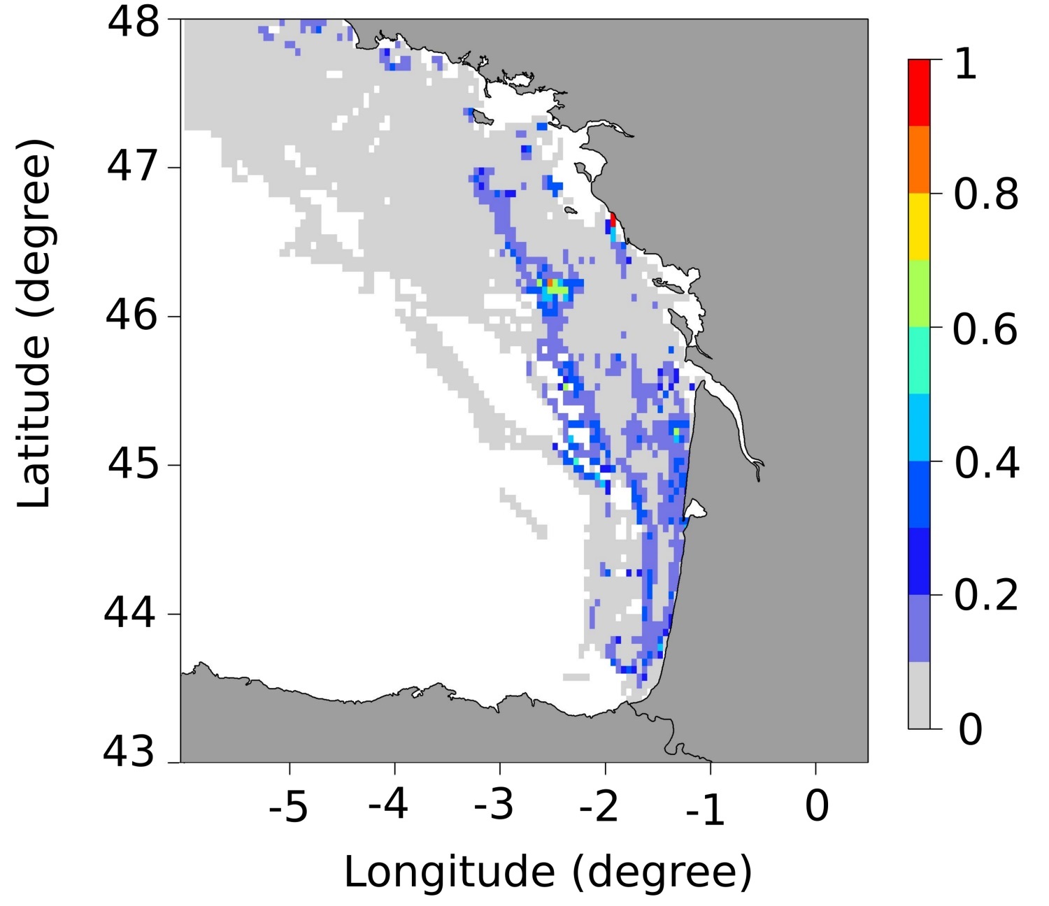
These maps represent the monthly probability of being a seabass spawning area for each month of the spawning season (January to April), and the mean probability of being a seabass spawning area over all spawning months in the English Channel - Celtic Sea. These probability maps were calculated by performing a geostatistical analysis of fishing data from geolocated vessels, and have a spatial resolution of 3 by 3 nautical miles.
-
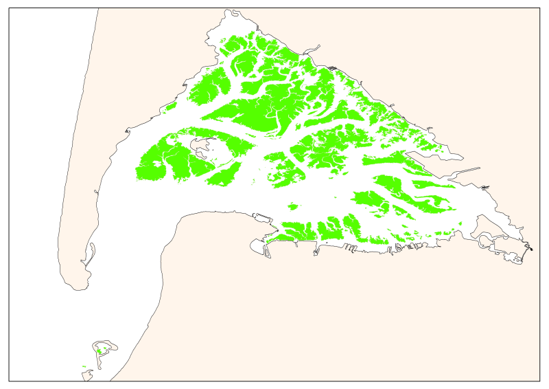
Map of the maximum extent of the seagrass Zostera noltti of Arcachon acquired in 2007-2008, under the supervisory control of the WFD (EU Water Framework Directive). Funded by the AEAG (Agence de l'Eau Adour Garonne) and Ifremer.
-
Since 2008, the Coastal Chemical Contamination Observation Network (ROCCH) has taken over from RNO (French National Observation Network for Quality in Marine Environments), which had existed since 1974. ROCCH aims to meet national, community and international obligations relating to monitoring chemicals in marine environments. It is therefore more of a control network than a heritage network as RNO once was. The backbone of ROCCH is to apply the European Water Framework Directive (WFD) and to meet the obligations set out in OSPAR Conventions and in Barcelona. As the WFD insisted on decentralization, ROCCH has gone from having just one project leader (the Ministry for the Environment) to having many decision-makers (water agencies, DIREN etc.). Chemical analyses are no longer conducted by Ifremer alone, but are attributed to other partners following calls for tender. ROCC also includes the monitoring of chemicals in shellfish production areas for the Food safety agency (DGAL) and the Ministry for Agriculture and Fisheries. Monitoring focuses on the three regulated metals: mercury, lead and cadmium in the given areas. Monitoring of these chemical contaminants is conducted in the three marine matrices: water, biota and sediment. Testing also includes imposex, the biological effect of tributyltin (TBT), as required by the OSPAR convention.
-
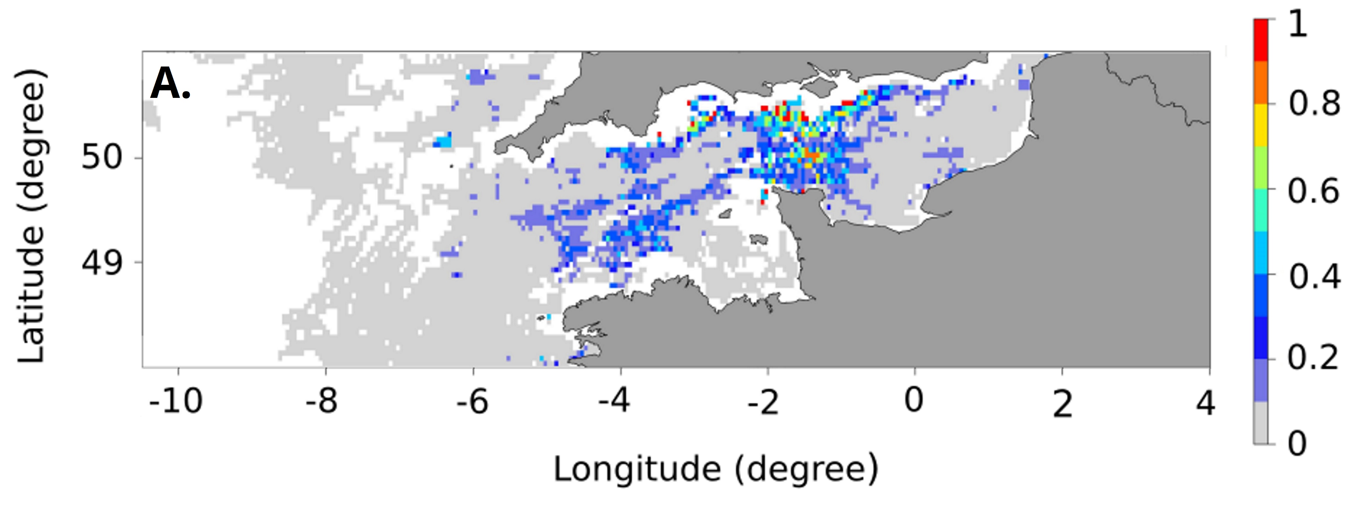
These maps represent the monthly probability of being a seabass spawning area for each month of the spawning season (January to March), and the mean probability of being a seabass spawning area over all spawning months in the Bay of Biscay. These probability maps were calculated by performing a geostatistical analysis of fishing data from geolocated vessels, and have a spatial resolution of 3 by 3 nautical miles.
-

The definitive coastal information system, Quadrige stores coastal observation and monitoring network data. In order to manage coastal monitoring data, Ifremer developed the Quadrige² information system. Quadrige is one element of the Water Information System (SIE) http:// www.eaufrance.fr, et à ce titre, contribue aux travaux du Secrétariat d'Administration National des Données Relatives à l'Eau (SANDRE) http://www.sandre.eaufrance.fr. Quadrige Marine Zones is a reference source unique to the Quadrige system. It is used to break down the coast of the French mainland and overseas territories into large areas and to connect each one with observation and monitoring locations.
-
The French national network (REMI) includes a regular monitoring system and a warning system: - The regular monitoring system checks that the level of microbiological contamination in each production area remains within the limits set by the classification defined in the prefectural decree and tests unusual occurrences of contamination. - The warning system is triggered when results of the monotoring programme exceed or are at risk of exceeding the norms defining the quality classes and thresholds, or in case of contamination risk (pollution spillage, storms, etc.), or even in the case of a suspected or confirmed epidemic in shellfish.
-

In order to manage coastal monitoring data, Ifremer has developed the Quadrige information system which connects a database to a wide array of tools for interpreting and designing information products. Quadrige is just one element of the Water Information System (SIE) www.eaufrance.fr and, as such, contributes toward the work of the French National Adminitrative Service for Water-Related Data (SANDRE) www.sandre.eaufrance.fr. The main aim of the Quadrige thematic databank is to manage and enhance data from coastal observation and monitoring networks. On a national level, Quadrige is today designated by the French Environment Ministry as the definitive information system for coastal waters, and the tool is therefore common to all of those working in the marine environment sector. The Quadrige databank is composed of data from the Quadrige database and products described or made available on the Envlit website. The Quadrige database contains results about most physical, chemical and biological environmental description parameters. The first data for example dates back to 1974 for the parameters relating to general water quality and contaminants, 1987 for phytoplankton and phycotoxins, 1989 for microbiology, from the early 2000s for the benthic zone. The data is permanently being updated. In Quadrige, an observation location is a geographical location where observations, measurements and/or samples will be taken. These locations can be located in a unique way thanks to their appearance on a map (polygon, line or point). A measurement location can be used by multiple programmes.