 Mon GéoSource
/Metropolitan France
Type of resources
Available actions
Topics
INSPIRE themes
Keywords
Contact for the resource
Provided by
Years
Representation types
Update frequencies
status
Scale
-
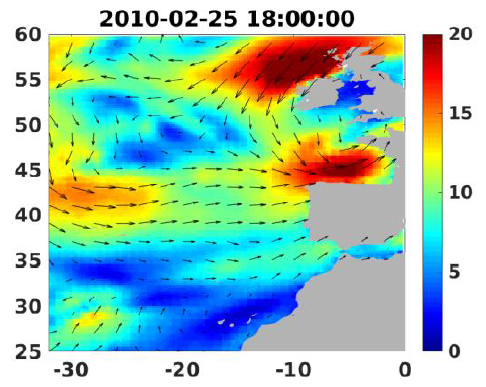
Wind analyses, estimated over the North Atlantic Ocean with a focus on some specific regions, are one the main ARCWIND (http://www.arcwind.eu/) project deliverables. They are estimated from various remotely sensed wind observations in combination with numerical model (WRF), with regular space (0.25deg in latitude and longitude), and time (00h:00, 06h:00, 12h:00, 18h:00 UTC), and based the method described in (Bentamy A., A. Mouche, A. Grouazel, A. Moujane, M. A. Ahmed. (2019): Using sentinel-1A SAR wind retrievals for enhancing scatterometer and radiometer regional wind analyses . International Journal Of Remote Sensing , 40(3), 1120-1147 . https://doi.org/10.1080/01431161.2018.1524174).
-
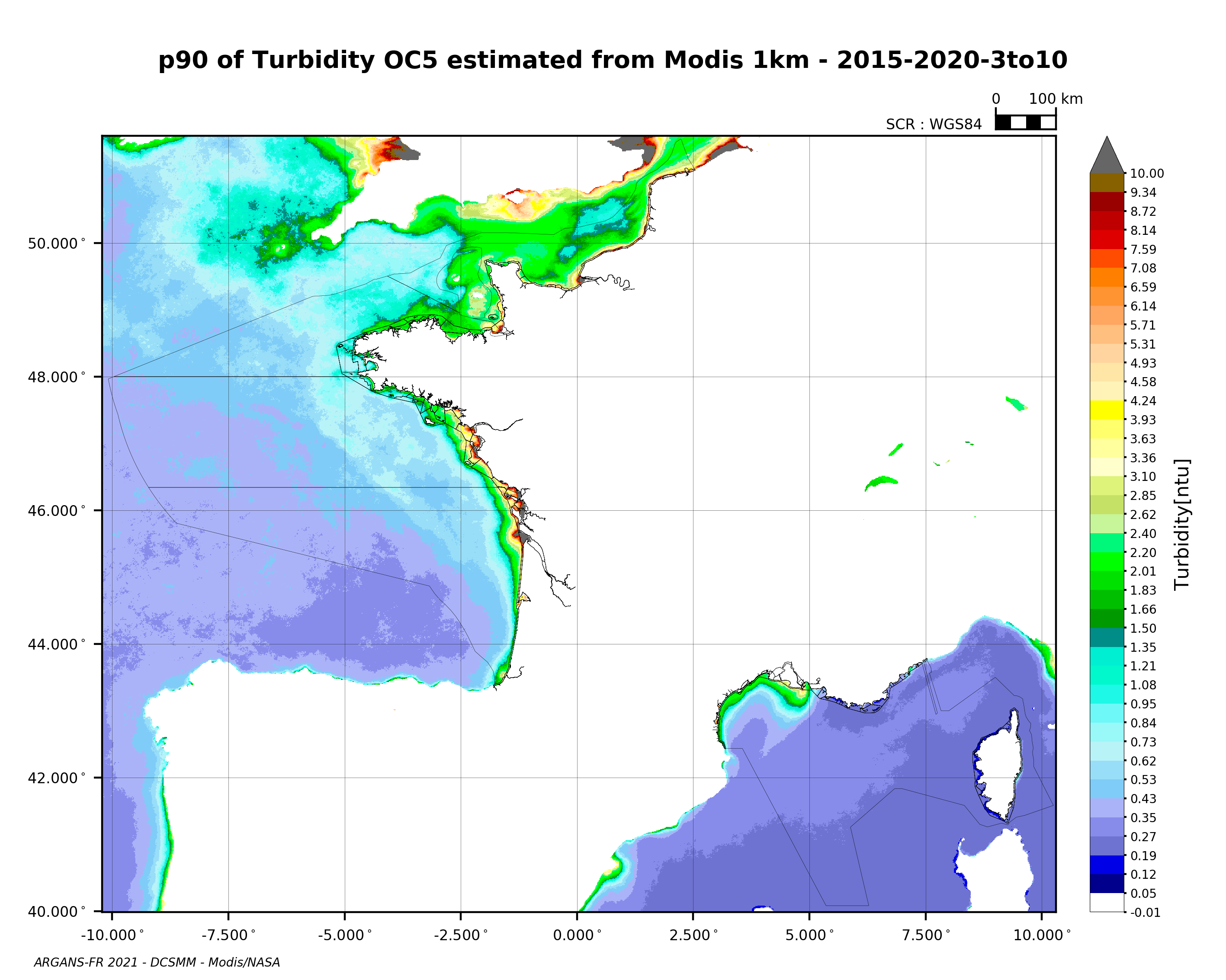
90th percentile of turbidity calculated during the productive period of the WFD (March-October) from 2015 to 2020, from the MODIS algorithm processed by OC5 IFREMER/ARGANS (Gohin et al 2002, Gohin 2011).
-
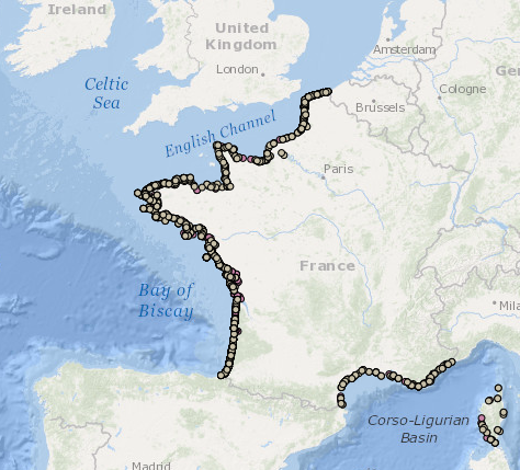
Occurrence data of strandings of marine mammals collected by the correspondents of the National Stranding Network (date, position, species) in metropolitan France in 2014-2020.
-
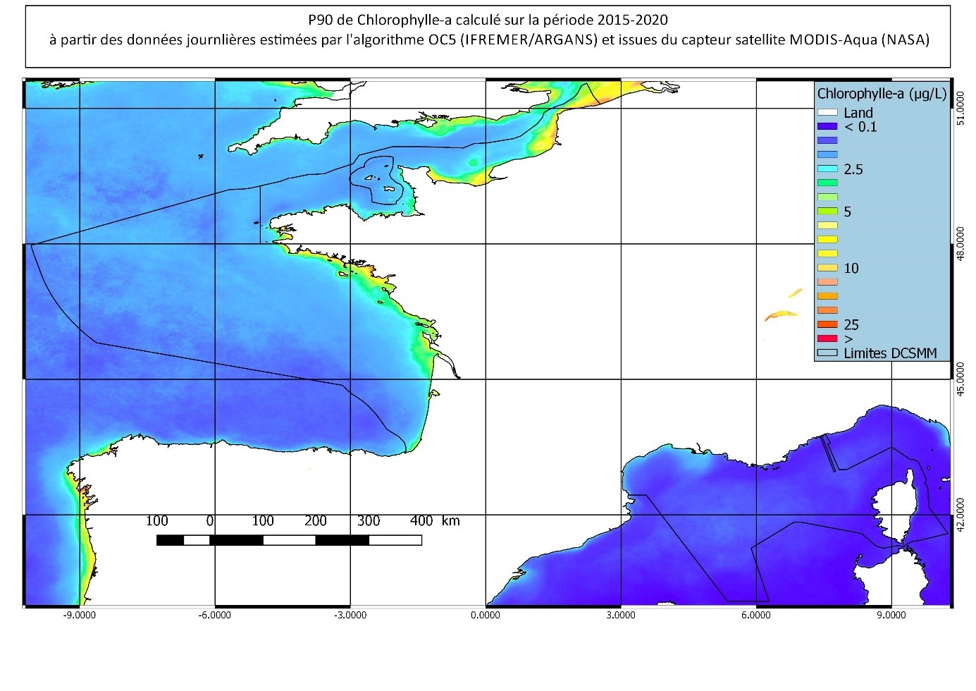
90th percentile calculated during the productive period of the WFD (March-October) from 2015 to 2020, from the MODIS Chl-a algorithm processed by OC5 IFREMER/ARGANS (Gohin et al 2002, Gohin 2011).
-
The French national network (REMI) includes a regular monitoring system and a warning system: - The regular monitoring system checks that the level of microbiological contamination in each production area remains within the limits set by the classification defined in the prefectural decree and tests unusual occurrences of contamination. - The warning system is triggered when results of the monotoring programme exceed or are at risk of exceeding the norms defining the quality classes and thresholds, or in case of contamination risk (pollution spillage, storms, etc.), or even in the case of a suspected or confirmed epidemic in shellfish.
-
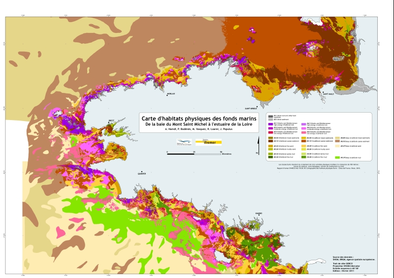
Eunis-classified physical habitats physiques resulting from the combination of three physical variables meshed at a resolution of 100 metres: nature of the substrates, biological area, shearing tension on the sea floor. Coasts of mainland France. Ifremer report "Hamdi Anouar, Vasquez Mickael, Populus Jacques (2010). Cartographie des habitats physiques Eunis - Côtes de France. Ifremer/AAMP agreement n° 09/12177764/FY. http://archimer.ifremer.fr/ doc/00026/13751/ "
-
REPHY is a national network covering the coast of the French mainland along with that of three of its overseas departments: Martinique, Guadeloupe and Reunion Island. The aims are as follows: - to observe all phytoplankton species in the coastal waters and to monitor events such as coloured water, exceptional blooms, and the proliferation of species which are toxic or disruptive to marine fauna, - Particularly to monitor species producing toxins which are dangerous to shellfish consumers . These objectives are complementary, as the regular monitoring of all phytoplankton species makes it possible to detect known toxic and invasive species, but also to detect potentially toxic species. It is the presence of these toxic species in the water which triggers the monitoring of toxins in shellfish. The mission of REPHY is to monitor shellfish in their natural environment (such as parks and deposits). For shellfish removed from marine environments (that is to say in shellfish logistics establishments or on markets prior to export), national monitoring and control plans are organised by the General Food Directive at the French Ministry of Agriculture. Analyses are performed by the accredited departmental veterinary laboratories as organised by the National Reference Laboratory from the French Food Safety Agency.
-
The national multidisciplinary RECOPESCA programme is a collaboration between volunteer fishermen and scientists for the automated collection of geolocated physical and fisheries environmental data from the coastal domain. The principle consists of installing sensors on gear to measure environmental parameters, from the surface to the bottom, and to record detailed data on fishing activity and effort. The data acquired feeds the operational coastal oceanography database (coastal component of Coriolis) and the fisheries database of the SIH (Harmonie). The programme thus responds to research issues (physical and fisheries), the implementation of the ecosystem approach to fisheries, support for public policies (DCSMM, DCF, CMEMS) and Ifremer's innovation in the coastal field.
-
The definitive coastal information system, Quadrige stores coastal observation and monitoring network data. In order to manage coastal monitoring data, Ifremer developed the Quadrige² information system. Quadrige is one element of the Water Information System (SIE) http:// www.eaufrance.fr, et à ce titre, contribue aux travaux du Secrétariat d'Administration National des Données Relatives à l'Eau (SANDRE) http://www.sandre.eaufrance.fr. Quadrige Marine Zones is a reference source unique to the Quadrige system. It is used to break down the coast of the French mainland and overseas territories into large areas and to connect each one with observation and monitoring locations.