 Mon GéoSource
D1: Biodiversité - Mammifères
Type of resources
Available actions
INSPIRE themes
Provided by
Years
Formats
Representation types
Update frequencies
status
Scale
Resolution
-
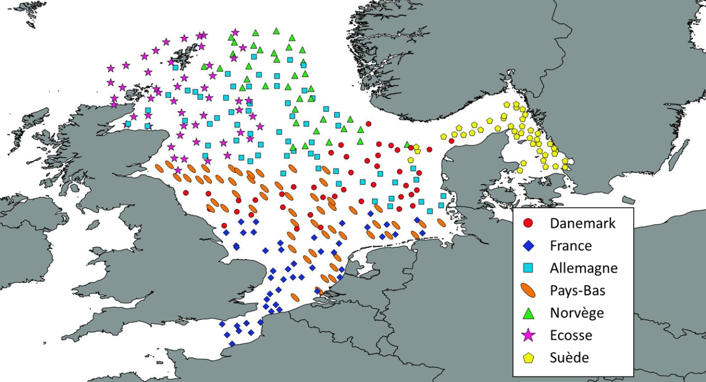
Like all EU Member States, France is obliged to collect and manage the data necessary to conduct the Common Fisheries Policy to assess the abundance and distribution of stocks. A "national multi-annual basic data collection programme" has therefore been set up in which scientific campaigns such as IBTS are integrated. This campaign is carried out in coordination with most of the countries bordering the North Sea, in the framework of the European Fisheries Data Collection Programme (DC-MAP). The research carried out over the last few decades has led to a shift away from fisheries issues stricto sensu (monospecific and geographically limited studies) towards a more integrated vision of the various components of marine ecosystems. This openness results from a desire to better understand the dynamics of exploited marine resources in order to improve diagnoses and management recommendations. The acquisition of data from these compartments at different stations makes it possible to establish a map of biotic and abiotic environmental parameters in the Channel and North Sea during the winter period, a period that is usually little studied, but which is crucial.
-
Occurrence data of strandings of marine mammals collected by the correspondents of the National Stranding Network (date, position, species) in metropolitan France in 2014-2020.
-
Occurrence data for marine mammals, birds and other marine megafauna collected by Megascope on fishing and oceanographic surveys (date, position, species).
-
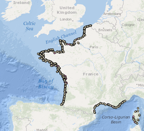
EVRWE is a multiannual survey with the following objectives: - Building up time series of abundance indices for the main dermersal and benthic species in the Celtic Sea and the Bay of Biscay. - Measuring inter-annual changes in their recruitment. - Mapping the spatial distributions of the species and their inter-annual variations, as well as looking for the origin of this variability (biotic and/or abiotic parameters, fisheries impact). - In the framework of the 'Bay of Biscay' challenge, the data collected are vital for understanding changes in faunal communities.
-
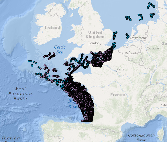
The observation of ecosystems by Ifremer's Fisheries Information System (SIH) is based on a network of sea cruises. It aims to assess the state of stocks of the various species fished in France and Europe. It also enables the characterisation of the marine ecosystem in which the populations evolve. 23 scientific cruises take place each year at sea, enabling data to be collected for more than 30 years for the oldest. Thanks to the use of standardised fishing gear, the data acquired each year on board scientific vessels or professional fishing vessels contribute to the calculation of the index of abundance, with thousands of fish taken during timed trawls. The fish are measured and their age is assessed by measuring their otoliths (small bones located in the inner ear of the fish).
-

Le produit Surval « Données par paramètre » met à disposition les données d'observation et de surveillance bancarisées dans Quadrige pour le thème "Déchets". Quadrige bancarise des données de description de l’environnement marin et de la ressource conchylicole (hydrologie, chimie, biologie, déchets…). Ce SI est le système d’information de référence sur les eaux littorales du Système d’Information sur l’Eau (SIE). Son domaine d’activité s’ouvre aux données marines pour le Système d’Information sur le Milieu Marin (SIMM). Pour cela, les référentiels Quadrige s’appuient sur les référentiels nationaux du Service d’Administration Nationale des Données et Référentiels sur l’Eau (SANDRE) ainsi que sur ceux du Service d’Administration des Référentiels marins (SAR). La diffusion Surval comprend toutes les données qui sont validées dans le système d'information à l'exception des données qualifiées à "Fausses" et de quelques données sous moratoire. La publication des informations est journalière, une modification dans la base de donnée est donc disponible le lendemain. L'accès aux données d'observation se réalise par lieu. Un lieu de surveillance est un lieu géographique où des observations, des mesures et/ou des prélèvements sont rattachés. Il est décrit de façon unique par son emprise cartographique (surface, ligne ou point). Un lieu de mesure peut être utilisé par plusieurs programmes. Les coordonnées d'acquisition d'une information peuvent être précisées. Les données disponibles concernent les suivis du thème DECHETS (flottants, plages, fond, enchevêtrement macrofaune et micro plastiques) et correspondent aux données bancarisées dans Quadrige. Les programmes de surveillance mis en place œuvrent conjointement dans le but de comprendre et protéger la qualité de l’environnement marin. La thématique met à disposition des données à partir de 1994 sur des lieux ponctuels, linéaires et surfaciques. L'emprise géographique est nationale : la métropole et les départements et régions d'outre-mer (DROM).
-
Visual Observations on the Dedicated Aerial Platform - 2. Sampling Programme- PACOMM/SAMM1 and SAMM2
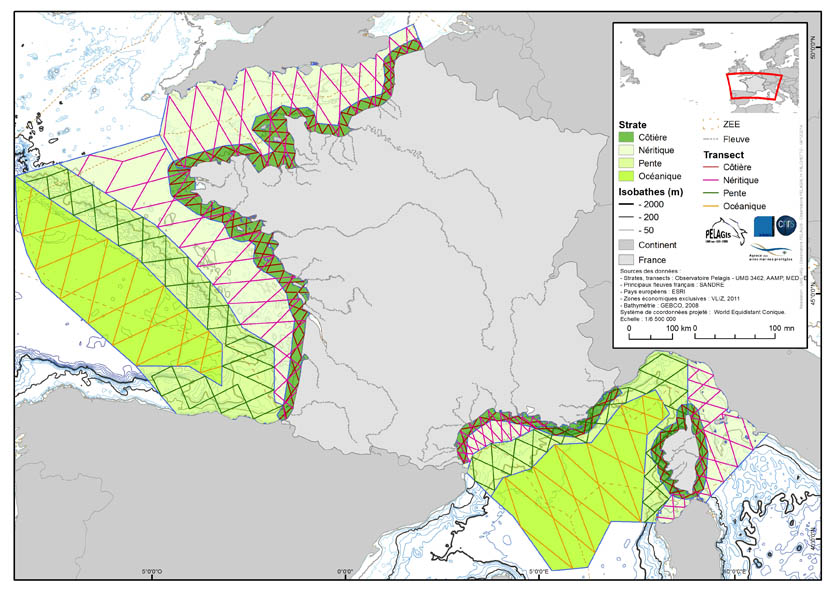
The associated data highlights the sampling programme for the data acquisition campaign of Observation on the Aerial Platform for the SAMM1and SAMM2 campaigns (Aerial Marine Megafauna Monitoring) conducted by the PELAGIS observatory (UMS 3462 ULR/CNRS). The sampling plan is composed of preestablished sampling strata and transects. These were drawn up according to the specific characteristic of the study area “Mainland France”, or FrM. Description of fields and values of allocation tables: : ( - field name, meaning: value, description of values) region char 5 Study area region_lbl char 50 labelled study area idCampagne (survey) char 15 Name of the campaign programme char 20 Programme name sector char 10 Sampling sector short ID strate char 5 Sampling strata short ID strate_lbl char 15 Labelled sampling strata areaKM double Strata surface area transect_name char 10 transect sampling length_km double Transect length start_x double Coordinates of the start of transect x in decimal degree start_y double Coordinates of the start of transect y in decimal degree end_x double Coordinates of the end of transect x in decimal degree end_y double Coordinates of the end of transect y in decimal degree
-
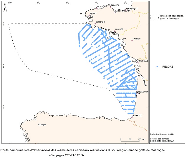
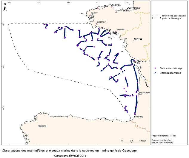
The objective of the PELGAS cruise is to monitor distribution and abundance of pelagic species fished in the Bay of Biscay, using two direct evaluation methods: acoustics and spawning estimates. The cruise was conducted in coordination with France, Spain and Portugal, in the framework of the European council regulations (EC No 1543/2000 of 29 June 2000 and No 1639/2001 of 25 July 2001).
-
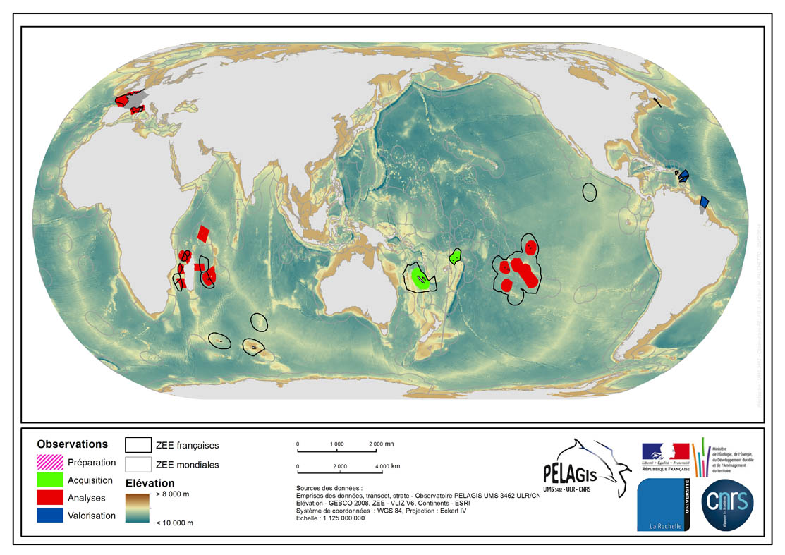
The associated data highlights the spatial influence of the dataset of the type “Visual Observations from an Aerial Platform” from the PELAGIS Observatory. These ranges represent the different areas of study on which the PELAGIS observatory conducted campaigns of visual observations from aerial platforms. Each area of study is associated with at least one campaign, with observers and geographical sectors linked to that campaign. Each sector is associated with bathymetric strips and transects related to each of the strips, with a few exceptions for the Indian Ocean region. Description of fields and values of the attribute tables : (- field name, meaning : value, description of values) - region, area of study specific to the PELAGIS observatory PELAGIS : OI/FRM/ AGFR/SOP/SP, region_lbl - programme, associated programme of which the campaign is a part: REMMOA/PACOMM, REcensement de la Mégafaune Marine par Observation Aérienne/Programme d'Acquisition sur les Oiseaux et Mammifères Marins - idCampagne, abbreviated name of the data collection campaign: OI/SAMM/ ANT/SOP/PF/GUY, Campagne Océan Indien/Suivi Aérien de la Mégafaune Marine/Sud Ouest Pacifique/Polynésie Française/ Guyane française - progress, current state of the campaigns, from collection to scientific optimisation : Preparation/Acquisition/ Analysis/Enhancement, campaign being prepared/under acquisition/being analysed/data enhanced within the context of a scientific publication.
-
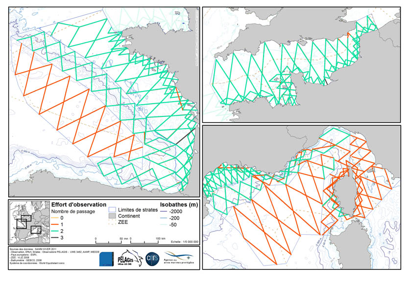
La donnée associée met en évidence l'effort d'observation réalisé lors de la campagne d'acquisition de données d'Observation sur plateforme aérienne SAMM1 (Suivi aérien de la Mégafaune Marine) réalisée par l'Observatoire PELAGIS. L'effort d'observation est matérialisé sous la forme d'un linéaire calqué sur les transects prévus. Description de la table attributaire : region char 30 Zone d'étude platform char 10 Plateforme d'observation : ovipa/ovibat survey char 15 Nom de la campagne computer char 5 Identifiant du système sur lequel le vol est effectué sector char 10 Secteur d'échantillonnage strate char 5 Strate d'échantillonnage transectN char 10 Transect d'échantillonnage crossNb int Nombre de passage sur le transectN effortGrp char 20 Numéro du groupe d'effort leg char 70 Numéro d'effort txt leg_id int Numéro d'effort (pour un LEG uniquement) left char 5 Arrière gauche (position gauche sur une plate-forme simple) right char 5 Arrière droit (position droite sur une plate-forme simple) navigator char 5 Navigateur (position centrale) beginTime char 20 Temps auquel a été commencé le parcours endTime char 20 Temps auquel s'est terminé le parcours status char 5 Status du parcours seaState char 5 Code pour l'état de la mer selon l'échelle de Beaufort cloudCover char 5 Couverture nuaugeuse défini par le système des octats (0 pour dégagé < 8 pour complètement couvert) glareFrom char 5 Début de la zone d'éblouissement en degré (le nez de l'avion 0°) glareTo char 5 Fin de la zone d'éblouissement en degré (le nez de l'avion 0°) glareSeverity char 5 ntensité d'éblouissement (0 aucun éblouissement < 3 éblouissement fort) turbidity char 5 Turbidité/transparence de l'eau (0 eau claire < 2 eau turbide, 9 turbidité inconnue) subjective char 20 Détectabilité. Estimation des observateurs en fonction des autres paramètres si les conditions sont bonnes ou non. Il s'agit de deux lettres, une pour le côté gauche et une pour le côté droit. (E excellentes, G bonnes, M moyennes et P pauvres). comment char 400 Commentaires sur le parcours lat double Latitude géographique en degré décimal du début du parcours lon double Longitude géographique en degré décimal du début du parcours latEnd double Latitude géographique en degré décimal de la fin du parcours lonEnd double Longitude géographique en degré décimal de la fin du parcours lengthKm double Longueur de l'effort en km engin char 30 Immatriculation de l'avion utilisé pour le vol speed int Vitesse (km/h) lors de la capture altitude char 15 Altitude (feet) lors de la capture coordN char 15 Code EPSG du système de coordonnées dans lequel les valeurs de distance ont été calculées