 Mon GéoSource
1000000
Type of resources
Available actions
Topics
INSPIRE themes
Keywords
Contact for the resource
Provided by
Years
Formats
Representation types
Update frequencies
status
Scale
Resolution
-
-
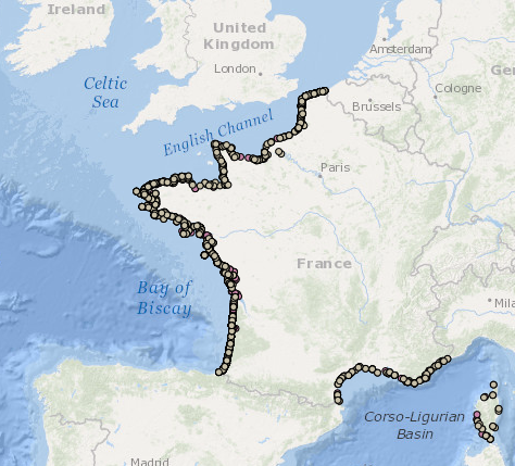
Occurrence data of strandings of marine mammals collected by the correspondents of the National Stranding Network (date, position, species) in metropolitan France in 2014-2020.
-
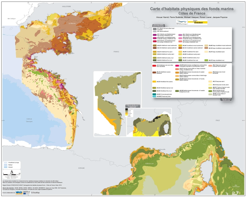
Eunis-classified physical habitats physiques resulting from the combination of three physical variables meshed at a resolution of 250 metres: nature of the substrates, biological area, shearing tension on the sea floor. Coasts of mainland France. Ifremer report "Hamdi Anouar, Vasquez Mickael, Populus Jacques (2010). Cartographie des habitats physiques Eunis - Côtes de France. Ifremer/AAMP agreement n° 09/12177764/FY. http://archimer.ifremer.fr/ doc/00026/13751/ "
-

Habitat typology obtained from the statistical analysis of underwater video data collected from the STAVIRO autonomous unbaited video technique (AMBIO project)
-
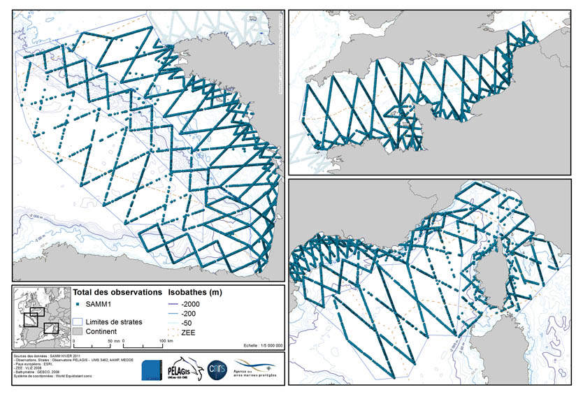
The associated data highlights the sampling programme for the data acquisition campaign of Observation on the Aerial Platform for the SAMM1campaign (Aerial Marine Megafauna Monitoring) conducted by the PELAGIS observatory.
-
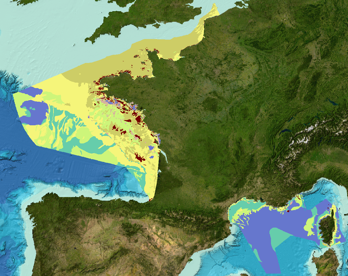
Sediment substrate map at 1 : 1 000 000 of the French metropolitan EEZ produced in the work-package 3 the European project EMODNet Geology, phase 2. And additionnal informations on index and confidence of original maps.
-
-
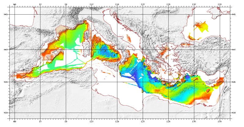
Bathymetric model (DTM) of the Mediterranean. MediMap group. Bathymetry data acquired by multibeam sounders during campaigns Almofront.leg1 and Almofront.leg2, Almofront, Bretane, Seamewe2, Heralis, Medee, Anaxiprobe, Almofront2 - leg1 and leg2, Prismed2, Marmara, Fanil, Tvic5 et 6, Progres, Maradja, Blac, Nautinil, Medor-Simed1 / 2 / 3 / 4 / 5, Maradja2, Sardinia, Prisme, Assemblage and Thertou. Integration of partner organizations DTM. This DTM is available at two cell sizes : 500 m and 1000 m.
-
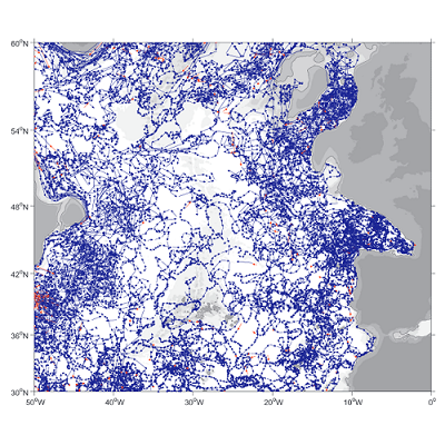
A world deep displacement dataset, named ANDRO, after a traditional dance of Brittany meaning a swirl, comprising more than 1300 000 deep displacements, has been produced from the Argo float trajectory data ('traj' files). ANDRO dataset was completed over the period 2000-2009, then was partially but yearly updated since 2010. For detailed information and status of the last released ANDRO product, please visit the dedicated Argo France web page: https://www.umr-lops.fr/SNO-Argo/Products/ANDRO-Argo-floats-displacements-Atlas One important feature of ANDRO is that the pressures measured during float drifts at depth, and suitably averaged are preserved in ANDRO. To reach this goal, it was necessary to reprocess most of the Argo raw data, because of the many different decoding versions (roughly 100) not always applied by the DACs to the displacement data because they were mainly interested in the p,t,S profiles. The result of our work was the production of comprehensive files, named DEP (for 'déplacement' in French), containing all the possibly retrievable float data.
-
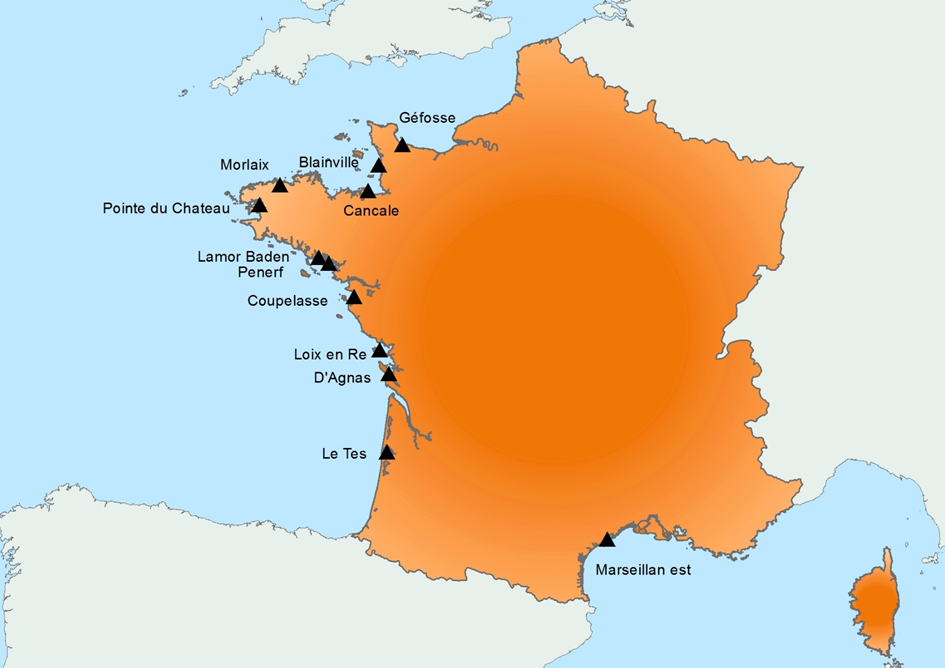
Created in 2015, it follows on from the RESCO launched in 2009, and REMORa launched in 1993. In 2015, the structure and operation of the former RESCO network was used to implement planned monitoring of oysters. More specifically, the sentinel batches used by the network, representing 3 age classes (6 months, 18 months of the previous year and 30 months of the previous year) are monitored regularly (frequency: bi-monthly or monthly). throughout the year at 12 national sites (corresponding to former RESCO sites). At each passage, counts are made to assess the mortality rate, and different types of laboratory diagnostic tests will be performed: - initially, the new spat batches (Ifremer Standardized Spats) will undergo specific PCR analyzes to search for potentially present infectious agents (OsHV-1 and Vibrio aestuarianus) but also non-specific analyzes (histology, classical bacteriology) for the possible detection of other pathogenis agents ; - for the detection of emerging diseases, the first dying batches detected for each age group, for each site, will undergo specific laboratory (OsHV-1 and Vibrio aestuarianus PCR) and non-specific (histology) diagnostic tests in order to detect as early as possible emerging diseases in these sentinel batches; - for the detection of exotic diseases, in the absence of a hierarchy of exotic diseases being available for oysters, it was decided to monitor the parasite Mikrocytos mackini because infection with this parasite is regulated at European level, on one of the RESCOII sites (Loix en Ré) previously identified as a site at risk with respect to the introduction of this parasite. In addition to these mortality follow-ups and the laboratory diagnoses, each site is equipped with a probe to allow it to gather environmental parameters (temperature, pressure, salinity) at high frequency. The various results are stored in the Quadrige² database, and are available for the various actors involved. The network is closely linked to a dedicated website which allows the dissemination of objectives, protocols and results, and which will be updated every month. In parallel, newsletters summarizing the results obtained are sent by e-mail every month to the State services.