 Mon GéoSource
100
Type of resources
Available actions
Topics
INSPIRE themes
Keywords
Contact for the resource
Provided by
Years
Formats
Representation types
Update frequencies
Scale
-
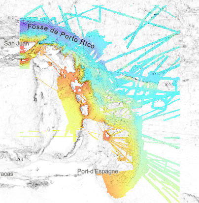
Bathymetry – Lesser Antilles volcanic arc: compilation of multibeam data, grid resolution 1/16 arc minute, 2020. Restriction : the DTM largely overlaps national EEZ. The entire product cannot be freely disseminated. Processing : Since the beginning of the 1990s, the scientific exploration of the West Indian arc has provided the opportunity for regular acquisition of multibeam bathymetry. About twenty scientific cruises and valued transits feed a remarkable database and offer a wide bathymetric coverage of this geological structure. They were assembled to produce a bathymetric model of the entire region. Multibeam data were controlled and processed with the Ifremer Globe software. A similar processing flow is applied to each dataset: - Selection of relevant profiles for acoustic coverage of the study area - Automatic and manual filtering of outliers and erroneous data - Control of overlapping zones - Production of a digital terrain model. Depth layer is calculated as the average of soundings in each pixel. All DTMs are merged into a unique DTM for the area. The final product is a double-layer raster at 1/16 minute steps (~ 100 m), a bathymetric layer and data source identifier layer. Data processing is described in this specific report : "Talbot Sophie (2019). Evaluation d'une méthodologie pour la compilation de données bathymétriques." https://w3.ifremer.fr/archimer/doc/00613/72480/ Multibeam data from scientific cruises from 1992 to 2017: - ESCARTIN Javier, LE FRIANT Anne, FEUILLET Nathalie (2017) SUBSAINTES cruise, RV L'Atalante, https://doi.org/10.17600/17001000 - MARCAILLOU Boris, KLINGELHOEFER Frauke (2016) ANTITHESIS 3 cruise, RV Pourquoi pas ?, https://doi.org/10.17600/16001700 - MARCAILLOU Boris, KLINGELHOEFER Frauke (2013) ANTITHESIS LEG1 cruise, RV L'Atalante, https://doi.org/10.17600/13010070 - FEUILLET Nathalie (2009) GWADASEIS cruise, RV Le Suroît, https://doi.org/10.17600/9020020 - LEBRUN Jean Frédéric (2009) KASHALLOW 2 cruise, RV Le Suroît, https://doi.org/10.17600/9020010 - LAIGLE Mireille, LEBRUN Jean Frédéric, HIRN Alfred (2007) SISMANTILLES 2 cruise, RV L'Atalante, https://doi.org/10.17600/7010020 - PATRIAT Martin (2007) ANTIPLAC cruise, RV L'Atalante, https://doi.org/10.17600/7010010 - DEPLUS Christine, BOUDON Georges (2002) CARAVAL cruise, RV L'Atalante, https://doi.org/10.17600/2010030 - MASCLE Alain (2002) CARAMBA cruise, RV L'Atalante, https://doi.org/10.17600/2010010 - DEPLUS Christine (1998) AGUADOMAR cruise, RV L'Atalante, https://doi.org/10.17600/98010120 - LE PICHON Xavier, LALLEMANT Siegfried (1992) MANON cruise, RV L'Atalante, https://doi.org/10.17600/92000211 Valued transits Leve_smf (https://doi.org/10.17600/16010800), Lobestory (https://doi.org/10.17600/4010030), Guyaplac (https://doi.org/10.17600/3010050), TRtoufdf, transit from Toulon to Fort-de-France Dormasis (https://doi.org/10.17600/92000411), Faranaut/15N (https://doi.org/10.17600/92000311), Fara-Seadma1 (https://doi.org/10.17600/91004411), Fara Published DTM : Ryan, W.B.F., S.M. Carbotte, J.O. Coplan, S. O'Hara, A. Melkonian, R. Arko, R.A. Weissel, V. Ferrini, A. Goodwillie, F. Nitsche, J. Bonczkowski, and R. Zemsky (2009), Global Multi-Resolution Topography synthesis, Geochem. Geophys. Geosyst., 10, Q03014, doi: 10.1029/2008GC002332
-
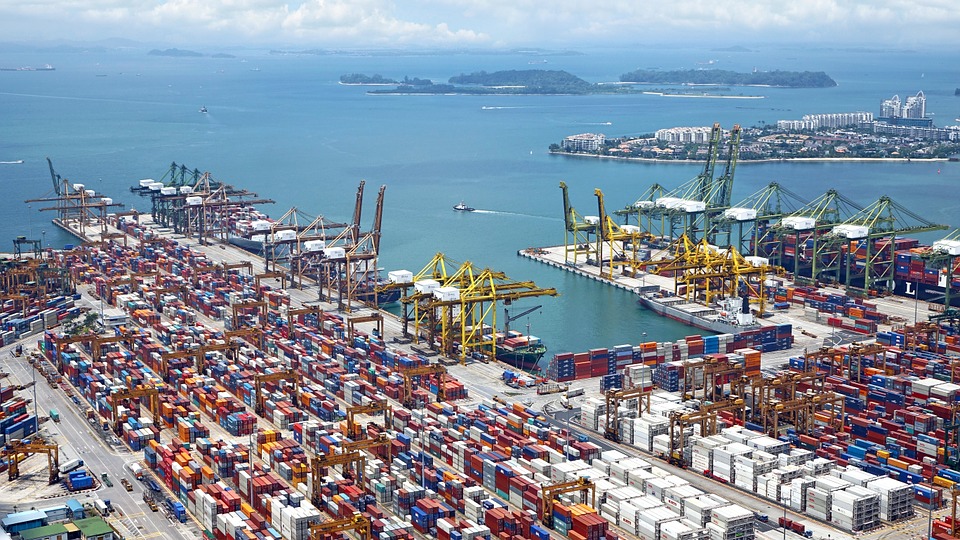
World list of seaports. In its 2021 version, the repository includes 13709 ports for 187 countries. The list of seaports has been drawn up on the basis of the information available in the European reference system of places used in the framework of the Common Fisheries Policy and, more particularly, by the Electronic Recording and Reporting System (ERS), the list of ports identified by the UNECE (2021-1). An assessment of the infrastructures present along the coastline made it possible to identify other ports that were not listed. Each geographical position has been verified with Google Earth in WGS84. Each port is associated with information relating to the country (ISO 3 coding), the UNECE or ERS 5-character coding, the name, the geographical position in WGS84 (latitude and longitude), the status of the port indicating whether it is referenced by Unece (UNECE), by the EU/ERS (ERS) or by both (UNECE/ERS) In case the port is not referenced by UNECE or ERS, the status is N/A. For French ports, the reference system integrates the ports of the French overseas departments and territories with the national codification. Inland ports have also been integrated in 2021.
-

Topologie détaillée des ouvrages d'Eau Potable (Sites de captage, Réservoirs) et d'Assainissement (STEP, Postes de Refoulement, Déveroirs d'Orage).