 Mon GéoSource
/Human Activities/Industrial Fishing
Type of resources
Available actions
Topics
INSPIRE themes
Keywords
Contact for the resource
Provided by
Representation types
Update frequencies
status
Scale
Resolution
-

The repository of commercially exploited species of interest in the Fisheries Information System is based on the FAO's ASFIS repository enriched with species of high commercial interest in France (metropolitan and overseas).
-

The repository of location in the Fisheries Information System is divided into 3 categories: places on land, areas at sea and regulatory areas at sea. Each of these is organised hierarchically. There are 93 levels of places in Harmonie: a metadata sheet exists for each of them with, when it exists, a geographical layer.
-

The gear repository of the Fisheries Information System includes, on the one hand, the FAO fishing gears enriched with national specificities and, on the other hand, the sampling gears used during the fisheries surveys conducted by Ifremer and its partners.
-

A metier in the Fisheries Information System is a fishing practice defined by a fishing gear and a target species. They are used for statistical purposes to evaluate fishing strategies and efforts.
-

Size-weight relationships are specific to each scientific species and its environment. They allow the size of an individual to be determined from its weight or vice versa. These relationships are established statistically from a sample of individuals representative of the species.
-

The scientific species repository of the Fisheries Information System lists the species observed during fishing campaigns or within the framework of the observations of collection programmes (ObsVentes, ObsMer, Campaigns, etc.).
-

The MFSP repository of the Fisheries Information System corresponds to the combination of Parameters, Supports, Fractions, Methods and Units. It allows variables to be entered, banked and retrieved. It is associated with many other repositories: species, gear, etc.
-
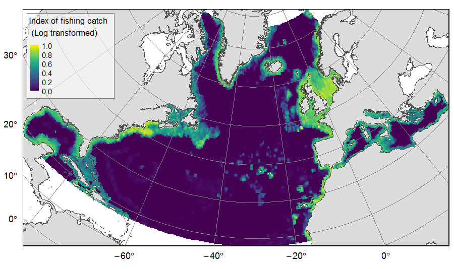
Distribution of catch from deep-sea impacting fishing on the North Atlantic (18°N to 76°N and 36°E to 98°W), for the period 2010-2015. The average of yearly fishing catch for the period 2010-2015 is displayed as an index on the ATLAS grid of 25km * 25km resolution. Source data originated from the Global Fisheries Landings V4.0 database. The dataset was filtered to select only the fishing gears that have an impact on large areas of the seafloor (dredges, bottom trawls, and Danish seines). Within each cell, all remaining catch records were summed to get the total catch rate of the considered year. This dataset was built to feed a basin-wide spatial conservation planning exercise, targeting the deep sea of the North Atlantic. The goal of this approach was to identify conservation priority areas for Vulnerable Marine Ecosystems (VMEs) and deep fish species, based on the distribution of species and habitats, human activities and current spatial management.
-

For some commercial species, coefficients called live weight equivalents allow the live weight of the fish to be calculated from the weight recorded on landing, or from the net weight of the various processed products prepared on board or in factories located on the coast.
-
This dataset was built to feed a basin-wide spatial conservation planning exercise, targeting the deep sea of the North Atlantic, in the framework of the ATLAS H2020 project. This approach aimed to inform Marine Spatial Planning and conservation initiatives for the deep sea of the North Atlantic, by identifying conservation priority areas for the Vulnerable Marine Ecosystems (VMEs) and deep fish species and discussing the efficiency of the current spatial management context relatively to conservation stakes. This publication provides (1) the links to spatial datasets used as an input, (2) the R scripts used to run the final conservation scenarios together with associated table of targets and connectivity matrix, that can be run on the input data, and (3) the outputs of the final scenarios constructed and computed for ATLAS. Produced by IFREMER. This output reflects the authors’ views and the European Union is not responsible for any use that may be made of the information it contains. Please note that you use these data at your own risk. No warranty is expressed or implied and no liability is accepted for any inconveniences or damages that may ensue from their use.