 Mon GéoSource
oceans
Type of resources
Available actions
Topics
INSPIRE themes
Keywords
Contact for the resource
Provided by
Years
Formats
Representation types
Update frequencies
status
Scale
Resolution
-
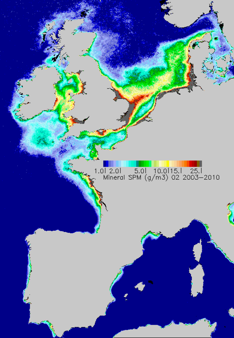
Map of average monthly non-algal suspended matter carried out in the period 2003-2010. TSS are estimated from the water reflectance using a specific algorithm developed at Ifremer.
-
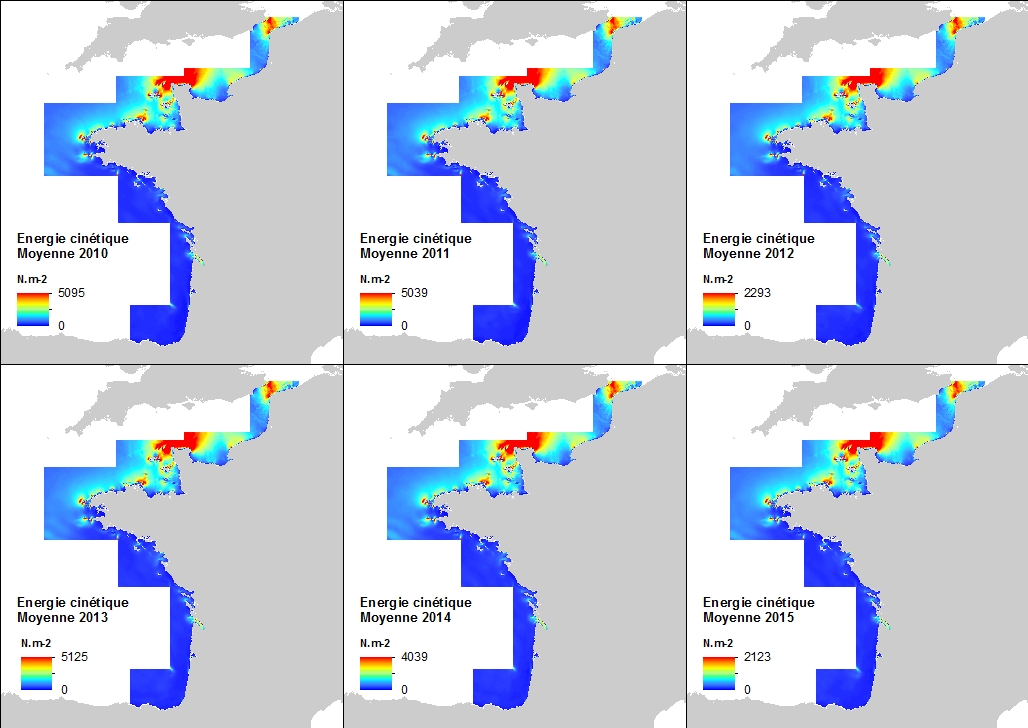
This annual statistics at 500m horizontal resolution was produced from the archived time series of MARS 3D physics model hindcast runs along French Atlantic Coast. The variable that is available here is the Kinetic Energy induced by currents caused by tide, water density gradients and action of winds. The formula used for the Kinetic Energy calculation is 0.5mv², where m is the density of seawater (1027 kg.m-3) and v is the current-induced velocity. Values are expressed in N.m-2 (Newton per square meter). The vertical level is the sea surface.
-
-
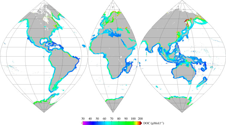
Monthly mean of Dissolved Organic Carbone (DOC) (2002-2012) for coastal areas, at global scale, for MERIS sensor, with POLYMER atmospheric corrections. Ref: V Vantrepotte, F Danhiez, H Loisel, S Ouillon, X Mériaux, A Cauvin and D Dessailly. CDOM-DOC relationship in contrasted coastalwaters: implication for DOC retrieval from ocean color remote sensing observation. OPTICS EXPRESS 33 Vol. 23, No. 1 DOI:10.1364/OE.23.000033 2015
-
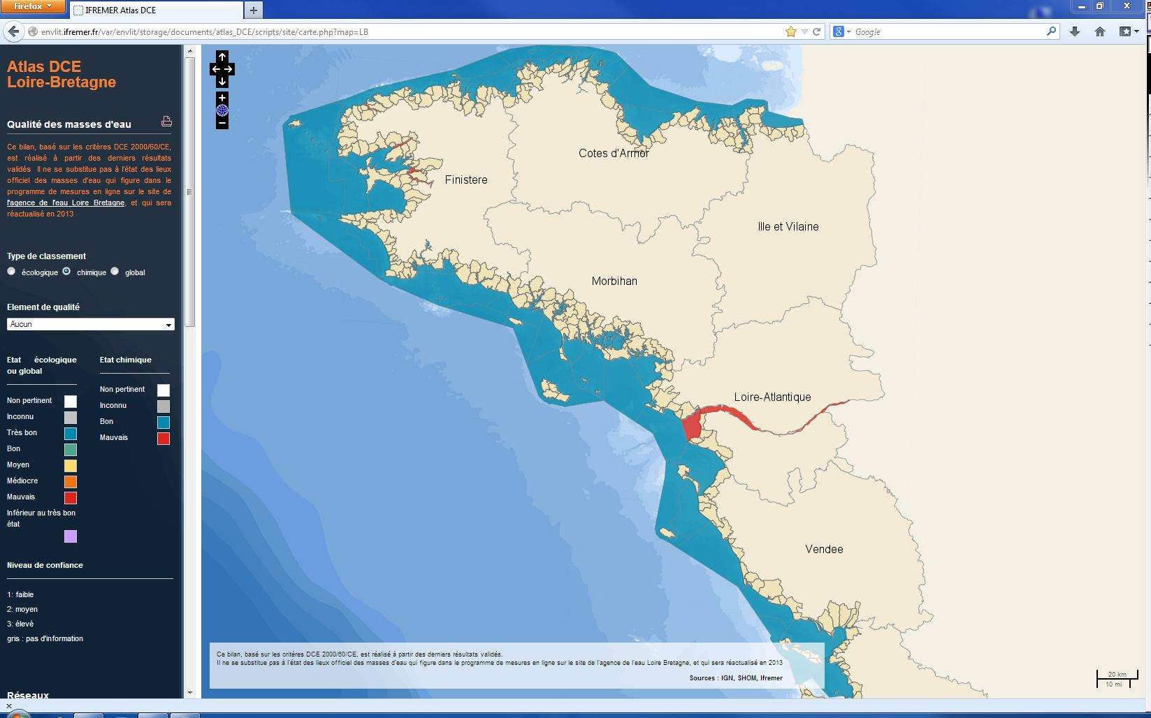
The chemical status of a coastal water body (coastal water or transition water) is determined by the most declassing of the defined states for heavy metals, pesticides, industrial pollutants and other pollutants taken into account by the WFD . The assessment is done once per management plan (once every six years). The most recent assessment of the state of the chemical state is presented in the DCE Loire-Bretagne atlas. Earlier reports are available in annual archives.
-
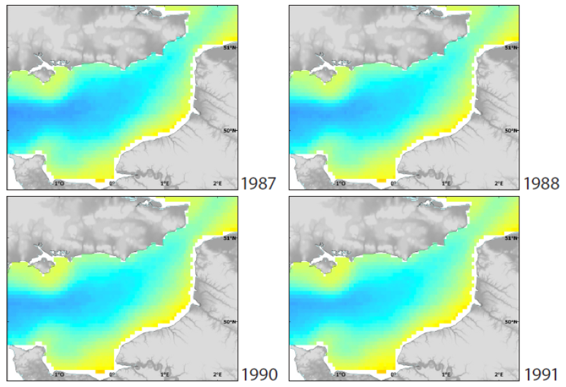
The English Channel is a biogeographical transition zone, situated between warm temperate and boreal marine province. This status enables the early detection of trends in the oceanic climate regime between two provinces. Mean SST maps for February (coldest month of the year) and August (warmest month of the year), from 1986 to 2006, were produced.
-
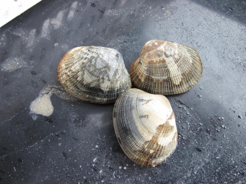
Since 2001, an annual stock assessment of Manila (Ruditapes philippinarum) and European (Ruditapes decussatus) clams has been carried out in March in the Gulf of Morbihan and the Noyalo River. The objectives of this survey are : 1) estimate by direct assessment, the biomass of the stock and its geographical distribution; 2) estimate the exploitable biomass and exploitation potential for the sampled sites in particular, in areas reserved for professional fishing; 3) to establish a diagnosis, with a medium-term vision, on the state of the stock; 4) to propose the implementation of appropriate management measures. Two cruises were also carried out in 1996 and 1997.
-
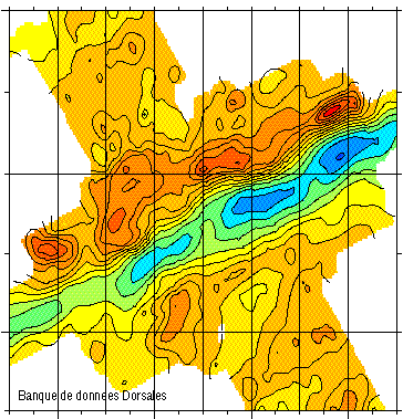
Gravimetry data of the ridge axis of Mohn's ridge (NE Atlantic) in order to study the mecanisms of the oceanic accretion.
-
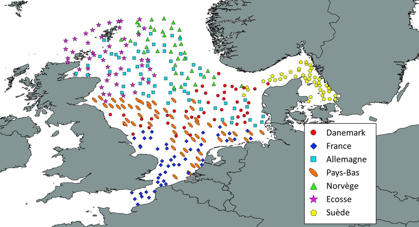
Like all EU Member States, France is obliged to collect and manage the data necessary to conduct the Common Fisheries Policy to assess the abundance and distribution of stocks. A "national multi-annual basic data collection programme" has therefore been set up in which scientific campaigns such as IBTS are integrated. This campaign is carried out in coordination with most of the countries bordering the North Sea, in the framework of the European Fisheries Data Collection Programme (DC-MAP). The research carried out over the last few decades has led to a shift away from fisheries issues stricto sensu (monospecific and geographically limited studies) towards a more integrated vision of the various components of marine ecosystems. This openness results from a desire to better understand the dynamics of exploited marine resources in order to improve diagnoses and management recommendations. The acquisition of data from these compartments at different stations makes it possible to establish a map of biotic and abiotic environmental parameters in the Channel and North Sea during the winter period, a period that is usually little studied, but which is crucial.
-
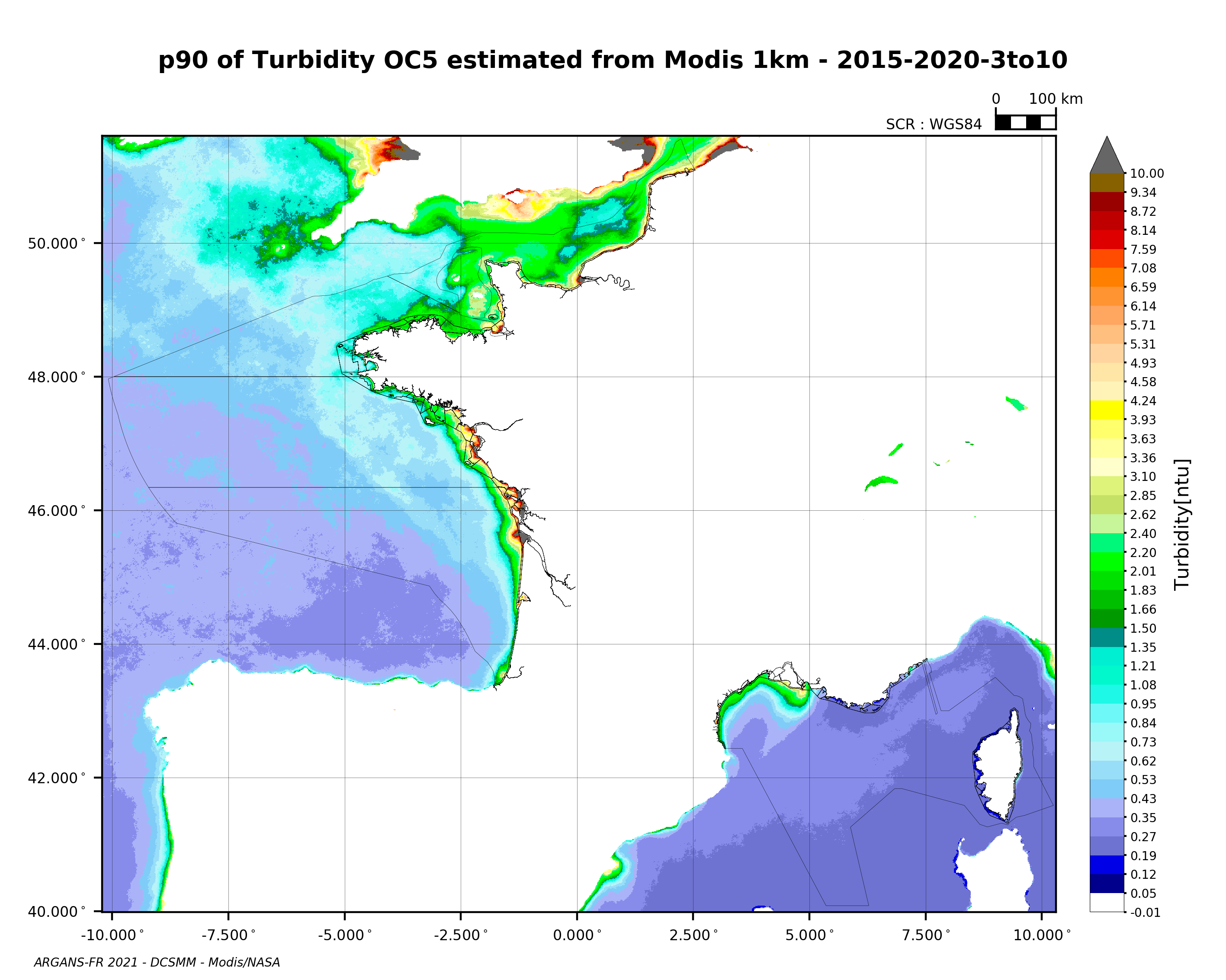
90th percentile of turbidity calculated during the productive period of the WFD (March-October) from 2015 to 2020, from the MODIS algorithm processed by OC5 IFREMER/ARGANS (Gohin et al 2002, Gohin 2011).