 Mon GéoSource
5 m
Type of resources
Available actions
INSPIRE themes
Provided by
Years
Formats
Representation types
Update frequencies
status
Scale
Resolution
-
Bathymétrie de la zone du plateau de Saint-Pierre et Miquelon (SPMPLAC, 2011), au pas de 5 mètres. Le modèle bathymétrique est réalisé à l'aide des données de sondeur multifaisceau Simrad EM302 de la campagne SPMPLAC, acquises à proximité des îles. Objectif : couverture d'une zone de recherche de l'épave du Ravenel. Description de la campagne : SPMPLAC, R/V Le Suroît, 2011, https://doi.org/10.17600/11020060 La campagne est principalement dédiée au programme Extraplac avec l'objectif d'une cartographie de la marge et des grands fonds au large de Saint-Pierre et Miquelon. Toutefois, quelques heures d'opérations spécifiques ont été également réalisées à proximité des îles. Rapport associé : Campagne SPMPLAC, Levé cartographique aux abords de Saint-Pierre, groupe de projet Extraplac, 2012
-
Cold-water coral habitat mapping in submarine canyons of the bay of Biscay was realized by the deep sea laboratory of Ifremer. Data came from the CE0908 cruise in the framework of the CoralFish project and as part of an agreement between Ifremer and the Agence des Aires Marines Protégées. The method was based on image analyses. Images were acquired using the towed camera « SCAMPI » during the CE0908 cruise (from 28/04/2009 to 19/05/2009, chief scientists: Anthony GREHAN, Brigitte GUILLAUMONT and Christian MOHN). Observed habitats were defined according to the CoralFish typology (J.S. Davies, B. Guillaumont, F. Tempera, A. Vertino, L. Beuck, S.H. Ólafsdóttir, C.J. Smith, J.H. Fosså, I.M.J. van den Beld, A. Savini, A. Rengstorf, C. Bayle, J.-F. Bourillet, S. Arnaud-Haond, A. Grehan, 2017. A new classification scheme of European cold-water coral habitats: Implications for ecosystem-based management of the deep sea, In Deep Sea Research Part II: Topical Studies in Oceanography, Volume 145, 2017, Pages 102-109, ISSN 0967-0645, https://doi.org/10.1016/j.dsr2.2017.04.014).
-
Cold-water coral habitat mapping in submarine canyons of the bay of Biscay was realized by the deep sea laboratory of Ifremer. Data came from the BOBECO cruise in the framework of the CoralFish project and as part of an agreement between Ifremer and the Agence des Aires Marines Protégées. The method was based on video and image analyses. Videos and Images were acquired using the ROV Victor 6000 during the BOBECO cruise (from 9/09/2011 to 11/10/2011, chief scientists: Sophie Arnaud-Haond et Anthony Grehan). Observed habitats were defined according to the CoralFish typology (J.S. Davies, B. Guillaumont, F. Tempera, A. Vertino, L. Beuck, S.H. Ólafsdóttir, C.J. Smith, J.H. Fosså, I.M.J. van den Beld, A. Savini, A. Rengstorf, C. Bayle, J.-F. Bourillet, S. Arnaud-Haond, A. Grehan, 2017. A new classification scheme of European cold-water coral habitats: Implications for ecosystem-based management of the deep sea, In Deep Sea Research Part II: Topical Studies in Oceanography, Volume 145, 2017, Pages 102-109, ISSN 0967-0645, https://doi.org/10.1016/j.dsr2.2017.04.014).
-
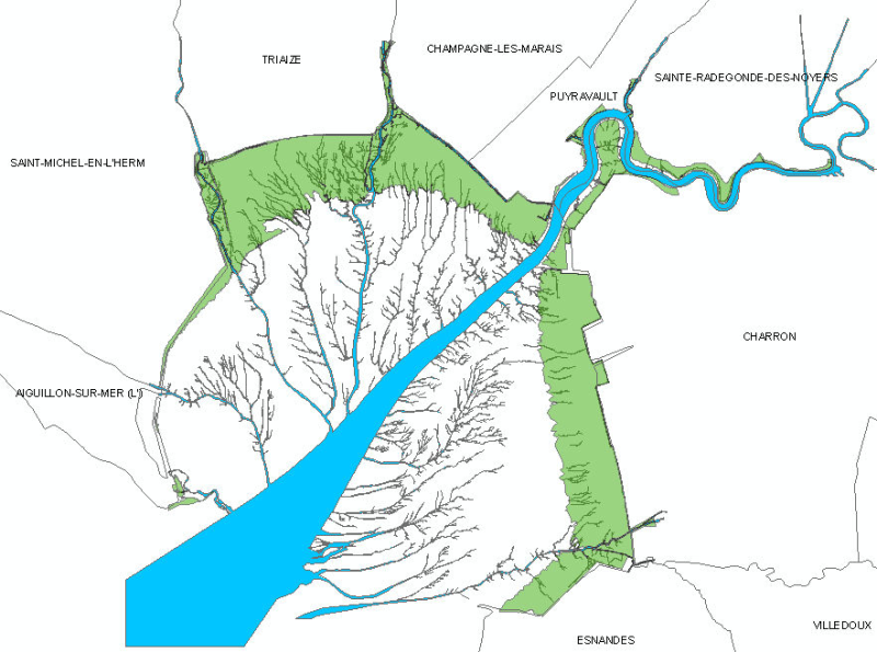
Cette carte du réseau hydrographique de la baie de l'Aiguillon et de l'embouchure de la Sèvre Niortaise a été réalisée dans le cadre de la numérisation des prés salé. Elle a été obtenu par la numérisation du réseau hydrographique visible sur l'orthophograhie 2000 de l'IGN au 1/5000. Il s'agit d'un unique polygone permettant de localiser le réseau hydrographique dans la baie, sur le pré salé et remontant le canal jusqu'à Marans.
-
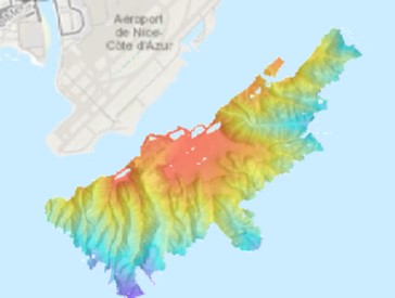
Bathymétrie du plateau au large de l'aéroport de Nice, en mer Ligure (campagne FLUID3D-2, 2019), au pas de 5 mètres. Les données ont été acquises par le sondeur SIMRAD ME70 (90 kHz, 81 faisceaux, ouverture 3 degrés) du N/O L'Europe. Référence verticale : niveau moyen des mers observé. Description de la campagne : DANO Alexandre, GARZIGLIA Sébastien (2019) FLUID3D-2 cruise, RV L'Europe, https://doi.org/10.17600/18000924