 Mon GéoSource
2008
Type of resources
Available actions
INSPIRE themes
Provided by
Years
Formats
Representation types
Update frequencies
status
Scale
Resolution
-
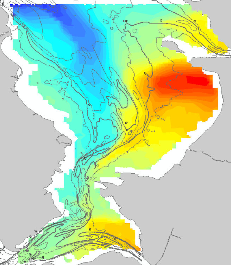
Résultat de la modélisation du temps de renouvellement ou Flushing time dans la baie de Marennes-Oléron représentant en jours le temps qu'il faut pour que 60% d'une maille soit renouvelée selon une condition de vent caractéristique : Ouest à 5m/s.
-
Cette carte des peuplements benthiques du secteur d'Arcachon a été réalisée d’après la thèse d'Yves Monbet, intitulée " Etude bionomique du plateau continental au large d'Arcachon (application de l'analyse factorielle) ", publiée en 1972. Cette étude sur les fonds chalutables de la côte landaise et girondine au large d’Arcachon a permis d’identifier 5 aires sédimentaires disposées parallèlement à la côte. Les peuplements benthiques sont répartis en 2 grands ensembles, l’ensemble côtier composé de 3 peuplements et l’ensemble subcôtier de 4 peuplements. La carte a été numérisée en 2005 et une harmonisation avec la typologie EUNIS a été effectuée en 2007 (projet REBENT).
-
Bathymétrie de l'archipel de Crozet, au pas de 400 mètres. Ce Modèle Numérique de Terrain est une compilation de données bathymétriques issues de différentes sources. Elle a été créé dans le cadre du projet d'extension du plateau continental juridique Extraplac. Les données sont issues des campagnes : - ROEST Walter, JOHNSON Sean (2010) MD176 Discovery Ridge-CrozetPlac cruise, RV Marion Dufresne, https://doi.org/10.17600/18001444 - ROEST Walter (2005) MD 150 /DELCANO RISE-KERGUEPLAC2 cruise, RV Marion Dufresne, https://doi.org/10.17600/5200060 - VIALLY Roland, BRUNET Christian, ROYER Jean-Yves (2008) MD 165 / KERGUEPLAC 3 cruise, RV Marion Dufresne, https://doi.org/10.17600/8200010 - SCHLICH Roland (1998) KERIMIS-MD109 cruise, RV Marion Dufresne, https://doi.org/10.17600/98200010 - METZL Nicolas, PIERRE Catherine (2001) VT 51 / OISO 6 cruise, RV Marion Dufresne, https://doi.org/10.17600/1200010 - ASLANIAN Daniel, HUMLER Eric, MICHEL Elisabeth (2002) MD 125 / SWIFT BIS-CARHOT cruise, RV Marion Dufresne, https://doi.org/10.17600/2200020 - MICHEL Elisabeth (2004) MD 136 / VIGO cruise, RV Marion Dufresne, https://doi.org/10.17600/4200110 - SANGIARDI Pierre (2015) MD 200 / LOGIPEV cruise, RV Marion Dufresne, https://doi.org/10.17600/15002800 - MCLACHLAN Ian (2008) MD 170 / SWIR-2008 cruise, RV Marion Dufresne, https://doi.org/10.17600/8200070 - S23-AB06, http://ricerca.ismar.cnr.it/CRUISE_REPORTS/2000-2009/AB06_REP/ - HUMLER Eric (2001) MD 121 / SWIFT cruise, RV Marion Dufresne, https://doi.org/10.17600/1200030 - KH0704L2, 2008, R/V Hakuho Maru - KN145L16, 1996, R/V Knorr - NBP0406, 2004, R/V Nathaniel B.Palmer
-
Cantonnement des males chanteurs de gorgebleues à miroir blanc (Luscinia svecica namnetum) à la période de reproduction (printemps), espèce typique des zones humides maritimes, inscrite à l¿annexe 1 de la directive 79/409, dit directive oiseaux.
-

Bathymetry of the French Guiana margin: the digital terrain model results from data compilation of 3 multibeam surveys conducted on the French research vessel RV L’Atalante. Grid resolution is 250 m. The DTM was processed as part of the French national program (EXTRAPLAC) for the delineation of the outer limit of the continental shelf beyond 200 nautical miles. - Guyaplac, 2003, R/V Atalante: Main source of the DTM was a cruise funded by the French National programme EXTRAPLAC. https://doi.org/10.17600/3010050 - Lobestory, 2004, R/V L'Atalante, https://doi.org/10.17600/4010030 - Cither1, 1993, R/V L'Atalante, https://doi.org/10.17600/93000010
-
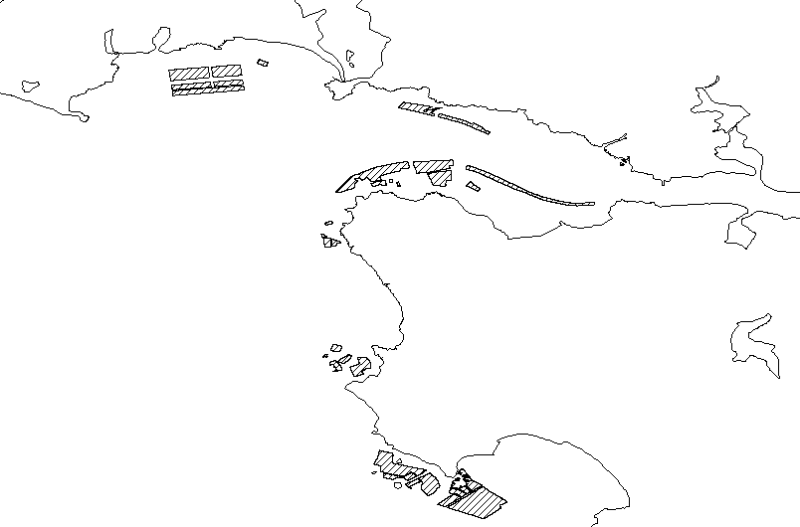
Zones de pêche des algues marines dans le département du Finistère (Laminaria Digitata et Laminaria Hyperborea).
-
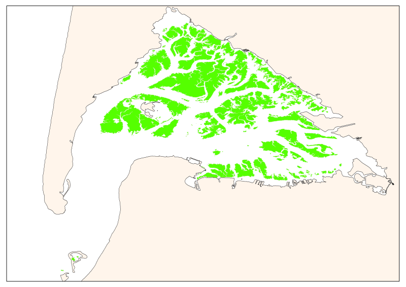
Map of the maximum extent of the seagrass Zostera noltti of Arcachon acquired in 2007-2008, under the supervisory control of the WFD (EU Water Framework Directive). Funded by the AEAG (Agence de l'Eau Adour Garonne) and Ifremer.
-

Bathymétrie entre Antibes et Nice, en mer Méditerranée (campagne ESSAIS EM1000, 1991), au pas de 15 mètres (WGS84, projection Mercator latitude 38°N). Les données ont été acquises avec le sondeur EM300 du N/O Le Suroît, lors de la campagne ESSAIS EM1000. Référence verticale : niveau moyen des mers Description de la campagne : SAUZADE Didier (1991) ESSAIS EM1000 cruise, RV Le Suroît, https://doi.org/10.17600/91003811
-
La carte des aménagements humains complète la carte des habitats intertidaux et subtidaux du site Natura 2000 FR5300034 Estuaire de la Vilaine [Partie 1/2] qui a a été réalisée en février 2008 par le bureau d'études télédétection et biologie marine (TBM) à la demande de la DIREN Bretagne dans le cadre du réseau européen Natura 2000.
-
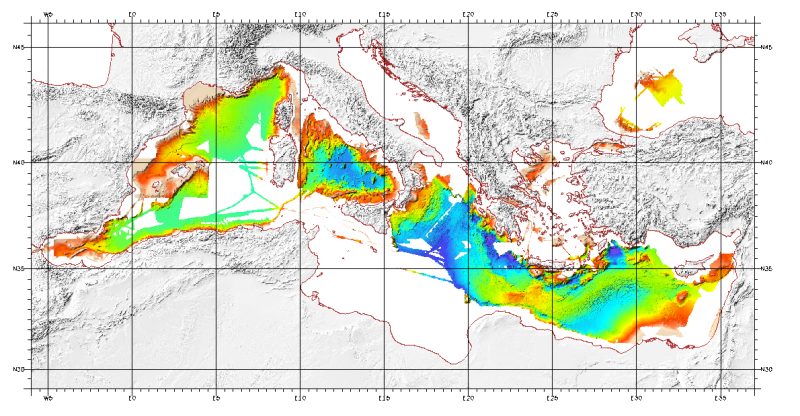
Bathymetric model (DTM) of the Mediterranean. MediMap group. Bathymetry data acquired by multibeam sounders during campaigns Almofront.leg1 and Almofront.leg2, Almofront, Bretane, Seamewe2, Heralis, Medee, Anaxiprobe, Almofront2 - leg1 and leg2, Prismed2, Marmara, Fanil, Tvic5 et 6, Progres, Maradja, Blac, Nautinil, Medor-Simed1 / 2 / 3 / 4 / 5, Maradja2, Sardinia, Prisme, Assemblage and Thertou. Integration of partner organizations DTM. This DTM is available at two cell sizes : 500 m and 1000 m.